Flight Simulator X flyers seeking finer Caribbean topography can switch to this 30-meter LOD10 terrain mesh, generated from NASA-METI ASTER GDEM digital elevation data and superseding the coarser S…
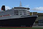
Queen Mary 2 Around the World anchors a detailed Cunard liner model at key U.S. cruise gateways inside FSX, situating the 1,132-foot vessel at Fort Lauderdale, New York, Los Angeles and Honolulu pi…
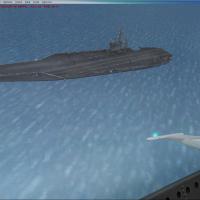
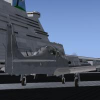
Four-Carrier Scenery v5.0 positions Javier Fernandez’s high-poly Nimitz-class platforms near Miramar KNKY, NAS Oceana, NAS Pensacola and Yokosuka, giving FSX pilots accurate U.S. Navy and JMSDF dec…
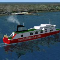
FSX add-on brings dynamic scheduled AI ferry traffic across the Irish Sea, placing Gmax-built HSS Stena and Norfolk Line vessels on authentic Belfast–Stranraer, Dun Laoghaire–Holyhead and Belfast–L…

Covering wartime hubs from Dinjan and Kunming to Myitkyina, this FSX WWII scenery package re-introduces 1942-45 China–Burma–India aerodromes with period crushed-rock runways, ADF/NDB beacons, low-f…

Aeroworx’s FSX vector scenery refines sub-equatorial Africa with sharpened coastline polys, satellite-derived DEM alignment, corrected riverbeds, reservoirs and dam walls, annotated rail corridors,…
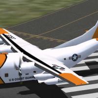
Operation Tight Reign places Con Son, Tan My, Lampang, and Sattahip into FSX’s Vietnam War theatre, coupling Loran-C chains, helipads, and period C-123 USCG AI flight plans for authentic 1966–75 So…
Aime Leclercq’s FSX fall texture overhaul swaps the stock landclass bitmaps with hand-edited, darker brown palettes, giving cities, villages and cultivated districts a crisper autumnal look worldwi…

Covering nine regional strips across the Bahamian archipelago and extending into the South Florida Keys, this FSX add-on installs lightweight BGL scenery that refreshes default layouts, airport obj…
This FSX scenery pack lays out the complete Red Bull Air Race portfolio, placing accurate pylons and exclusion zones across Rio de Janeiro’s shoreline, Monument Valley’s mesa skyline, Istanbul’s Go…
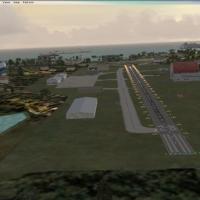
Compact update for FSX flyers mapping the Caribbean circuit, refreshing Puerto Rico’s Ramey (TJQB), Roosevelt Roads (NRR), Mercedita (TJPS) and Culebra’s former Navy field (PR18) while also adding …
FSX Curlyo’s Fun Antarctic Scenery introduces a cluster of fictional ICAO strips, light-hearted objects and a refreshed YMHB Hobart AFCAD, giving Microsoft Flight Simulator X pilots unconventional …
Covering Ramey (TJQB), Roosevelt Roads (NRR), Mercedita (TJPS), Culebra’s former Navy strip (PR18) and nearby La Romana (MDLR), this FSX flight-sim ADE package overhauls taxiway geometry, parking s…
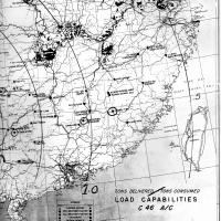
Adds CBIX-tagged WWII Allied airstrips across India—Karachi to Assam—plus linked Burma and China legs, complete with period crushed-rock runways, low-frequency ranges, NDB beacons and reference cha…
Mobile Air Base MAB-03 “Skyhaven” brings a relocatable aerodrome to the United States scenery index, offering FSX SP2/Acceleration users a hovering platform that cruises at 100 kt up to 1 000 ft, w…
Optimised for Microsoft Flight Simulator X, this Caribbean scenery pack revises the Virgin Islands’ default terrain across eight islands—including St. Thomas, St. Croix, Tortola and Virgin Gorda—ad…
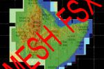
Covering Ethiopia, Eritrea, Djibouti and Somalia, this FSX mesh scenery add-on supplies high-resolution elevation data (LOD 0-9) that sharpens relief rendering, corrects landclass edges, enhances p…
Middle East AFCAD Pack 2 refines the default FSX gate and ramp layout for Doha (OTBD), Dubai (OMDB), Amman (OJAI/OJAM) and Aqaba (OJAQ), adding cargo stands, realistic fuel-truck nodes, extra taxiw…
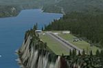
Covering eight bush strips and regional fields from coastal British Columbia into neighboring Alaska, this third Pro Hops package slips default-style mountain-hop destinations into FSX with negligi…
Covering 23 lightly detailed VFR airfields from Provincetown, MA to Oceanside, CA, this FSX scenery set lays out a pragmatic cross-country route for single-engine GA pilots, each leg capped at 200 …

