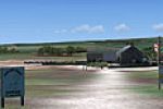
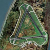
United Kingdom

Page 12

Sort
Reset
Preview screenshot

Unst Airport

Covering Britain’s northernmost strip, this FSX add-on places Unst Airport (EGPW) into Microsoft Flight Simulator X with revised AFCAD data, realistic apron markings and adjusted terrain that matches the grassland plateau, sheer cliffs and Baltasound shoreline, ideal for short-field VFR hops, light GA aircraft circuits and Orkney-Shetland route planning.

File Size
597.96 KB
Total Downloads
228
Star Rating
1/5
Screenshots
1
Preview screenshot

RAF Spilsby

This Microsoft Flight Simulator X scenery add-on recreates RAF Spilsby (UKSL) in Lincolnshire, the former 5 Group Bomber Command base for 207 and 44 Squadrons, featuring concrete runways, wartime perimeter track, T2 and B1 hangars, surrounding farmland and accurate geodata for circuit drills or cross-country VFR hops across eastern England.

File Size
952.79 KB
Total Downloads
228
Screenshots
3
Preview screenshot

North Pickenham Wind Farm

North Pickenham Wind Farm for Microsoft Flight Simulator X inserts a detailed turbine cluster into the Norfolk landscape just outside Swaffham, giving VFR pilots a precise navigation point on their aeronautical charts. Rotating blades, night lighting and balanced LODs keep frame rates steady for microlight, ultralight and GA sorties across eastern England.

File Size
592.76 KB
Total Downloads
226
Star Rating
3/5
Screenshots
1
No image available.

RAF Bicester

RAF Bicester for Microsoft Flight Simulator X reproduces the former bomber-command grass aerodrome in Oxfordshire, bringing hand-placed wartime hangars, brick control tower, accurate runway headings and peri-track geometry derived from ADE. Jon Davidson’s British military scenery blends with default VFR landclass, ideal for GA sorties, training circuits or vintage aircraft operations across the United Kingdom.

File Size
5.44 MB
Total Downloads
221
Preview screenshot

Hardy Monument

Hardy Monument scenery add-on places the octagonal 22 m stone tower on Black Down, Dorset (50°41′12″N 2°32′57″W), providing a coastal waypoint for GA traffic between Bournemouth, Yeovil and former RNAS Portland. Built for FSX and compatible with FS2004, it fits Horizon VFR Generation X terrain via zero-AGL adaptive placement. Seed9127.

File Size
455.02 KB
Total Downloads
220
Screenshots
1
Preview screenshot

Carlisle Airport

For EGNC, this FSX scenery addon redraws Carlisle Airport, Cumbria, with a stretched 7,500-ft 07/25 runway, dual-end ILS (108.30 MHz), part-length parallel taxiway, six-stand jet apron, upgraded firehouse, closed-runway markings and bird hazard placements for realistic approach planning; RWY 01/19 stays available for GA circuits, offering UK sim pilots a balanced IFR/VFR practice field.

File Size
3.97 MB
Total Downloads
217
Preview screenshot

A Day At The Seaside

West Sussex’s shoreline gains two little-known strips in ‘A Day at the Seaside’ for FSX and Horizon VFR Generation X: EGKC Bognor Regis provides an asphalt runway for GA twins, while the grass Bracklesham Bay strip suits microlights, incorporating photoreal terrain, tailored autogen, optional static aircraft and custom multicom channels.

File Size
785.92 KB
Total Downloads
217
Screenshots
2
No image available.

EGNH Blackpool Gate Signs Add-On

Gate signage is added to the stock EGNH Blackpool Airport, giving FSX pilots clear taxiway pointers and labelled parking stubs for smoother ground handling and stand allocation. The lightweight scenery tweak refreshes this regional UK airfield without touching performance, aiding VFR circuit work and AI traffic routing.

File Size
2.91 KB
Total Downloads
216
Preview screenshot

Clipgate And Pent Farm Grass

Clipgate Farm near Canterbury and nearby Pent Farm broaden FSX’s UK GA portfolio with two grass strips modelled at 1-metre terrain resolution, integrated with Just Flight/Horizon VFR photoreal tiles. Sloped runway profiles, tree-obstructed thresholds, bespoke sound layers and light vehicular AI provide a subdued yet authentic setting for short-field practice, requiring prior ‘A Day on the Farm’ libraries.

File Size
7.01 MB
Total Downloads
213
No image available.

Tresco Heliport

Centred on the Isles of Scilly, this EGHT scenery add-on for FSX/P3D places Tresco Heliport and its adjoining private airstrip with corrected helipad geometry, a static AW139, compact passenger lounge, parked farm tractors, mid-field footpath and standby fire appliance, offering VFR aviators a reliable cue for rotorcraft operations in Southwest England.

File Size
3.19 KB
Total Downloads
212
Preview screenshot

Welshpool Airfield

Welshpool Airfield (EGCW) scenery for FSX slots a precisely geo-referenced Mid Wales Airport into Microsoft Flight Simulator X, delivering aligned runway 04/22, Google-Earth-derived taxiways, bespoke hangars, air-ambulance pad, corrected AFCAD and CVX data, making this daylight-only GA hub in Powys a practical training, VFR waypoint for UK virtual pilots.

File Size
355.91 KB
Total Downloads
208
Screenshots
1
No image available.

Penzance Scenery V2

Covering Penzance Heliport (EGHK) in Cornwall, FSX Penzance Scenery V2 refreshes Microsoft Flight Simulator X with refined ground polys, updated AFCAD, bespoke terminal assets and helipad objects, realistic apron lighting and accurate coastline alignment, plus a self-installer for quick deployment, created by Harry Patten.

File Size
124.21 KB
Total Downloads
207
Preview screenshot

EGFE Haverfordwest Airfield

FSX pilots exploring Welsh airspace may add this freeware EGFE Haverfordwest Airfield scenery, which integrates Horizon GenX orthoimagery and mesh with updated AFD data, CVX flattens, custom hangars, vegetation and exclusion zones, employing Runway12 and UK VFR object libraries to portray the Pembrokeshire GA strip and ex-RAF site in credible scale.

File Size
279.05 KB
Total Downloads
207
Preview screenshot

Oxenhope For Neil's Microlights

Oxenhope for Neil’s Microlights is a UK airfield scenery add-on for FSX that refreshes the West Yorkshire strip with geo-referenced photoreal ground, bespoke autogen, accurate terrain mesh and the memorable burned-out caravan landmark, supplying VFR and microlight flyers with realistic short-field circuit references amid rolling Pennine countryside.

File Size
26.92 MB
Total Downloads
204
Star Rating
1/5
Screenshots
2
Preview screenshot

Oxenhope Airfield

Oxenhope Airfield for FSX and Horizon Gen-X Vol 3 recreates the exposed hill-top strip above Haworth in Yorkshire’s Brontë Country, delivering photoreal terrain, bespoke 3-D structures, stone-walled perimeters, short undulating runways, region-matched autogen trees, animated wind turbines and grazing horse models, with refined elevation mesh and a nominal UNICOM to sharpen STOL circuit work under British VFR rules.

File Size
1.24 MB
Total Downloads
204
Screenshots
3
Preview screenshot

East-Lochlane-Farm

East-Lochlane Farm for FSX positions a short grass runway amid Strathearn farmland just south of Crieff, giving Scottish Highlands VFR pilots a detailed rural GA strip drawn from Bryan Lockyear’s farm-strip guide; custom objects, photoreal ground polys, dynamic vegetation and optional Highland-cattle ambience add locality without taxing frame-rates.

File Size
36.42 MB
Total Downloads
204
Star Rating
5/5
Screenshots
20
Preview screenshot

Deanland Airfield

Low-level circuits above East Sussex benefit from this Deanland Airfield (EGNY) scenery for FSX, tuned for Horizon GenX Vol.1 photoreal terrain. Animated ground objects, bespoke autogen woodland and UK-VFR library assets render the private grass strip accurately, ideal for light GA VFR hops across the South Downs.

File Size
1.54 MB
Total Downloads
202
Screenshots
6
Preview screenshot

Turweston Aerodrome

Built for Microsoft Flight Simulator X, this UK add-on by Tim Dale refines Turweston Aerodrome EGBT with custom Gmax structures, updated AFD, realistic runway 09/27 markings, café-flight-school static elements and density-aware autogen, providing a reliable waypoint for East Midlands VFR circuits, PPL training and light IFR legs.

File Size
999.16 KB
Total Downloads
196
Screenshots
3
Preview screenshot

London Hatfield

Hatfield EGTH returns to the FSX map as a plausible modern regional hub, featuring a 7,200-ft ILS-equipped 06/24, a separate 3,000-ft GA strip, re-profiled taxiways, ten jet nose-in gates, service roads and ADE9x-generated detail, requiring no extra libraries—ideal for UK VFR or IFR circuit practice.

File Size
2.18 MB
Total Downloads
195
Preview screenshot

RAF Lasham

Rebuilt for FSX, this RAF Lasham scenery inserts the 1943 fighter aerodrome into Hampshire with geo-referenced runway alignment, period hangars from Ted Andrews’ library, accurate dispersals and parking for Typhoon, Spitfire and Mitchell AI traffic. Current glider operations and the UKLQ identifier are retained, allowing realistic VFR circuits over southern England’s chalk downs.

File Size
1.11 MB
Total Downloads
195
Screenshots
4

16 pages with 309 downloads.

previous12345678910111213141516next