Page 15
Searches the whole library — filter by sim & category on the results page
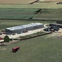
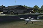
Ashcroft Airfield (EGCR) adds a faithful grass strip to the Cheshire countryside in FSX, featuring custom ground textures, hand-placed autogen farm buildings, accurate 09/27 runway profile, updated…

Lansdowne Monument scenery for FSX inserts the 125-ft 1845 obelisk atop Cherhill Down, Wiltshire, furnishing a UK landmark accurate to Horizon VFR photoreal mesh; the structure sits in its real-wor…
Covering the Orkney and Shetland archipelagos, this FSX add-on refines Horizon Gen X with corrected airfields and strips, custom lighthouse models, dynamic road traffic and GA/commuter AI schedules…
Rothwell Grass Strip brings a modest 550-metre turf runway and surrounding Northamptonshire farmland into FSX and P3D, matching Horizon/Just Flight VFR photo scenery, RWY12 libraries, and the wider…
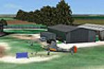
Covering the compact grass strip at Redlands near Swindon, this FSX scenery refresh aligns the airfield layout with current charts, adds custom hangars, microlight parking, accurate taxiways and AF…
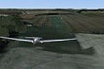
Easton-Maudit airstrip adds a 604 m × 23 m grass runway (16/34) and custom ground detail to Microsoft Flight Simulator X—ideal for microlight, STOL and general-aviation practice during UK VFR hops …
Barra Airfield (EGPR) sound pack enhances FSX flights over Scotland’s Western Isles with looping ambient seagull calls synced to the beach runway, integrating seamlessly with Horizon’s Outer Hebrid…
Covering Stoke Airfield on the Hoo Peninsula beside Medway’s tidal flats, this FSX scenery layer integrates with Just Flight/Horizon VFR photo terrain, bringing a curved coastal runway profile, cor…
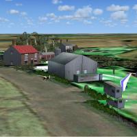
Covering Alcester’s 960-metre north–south grass runway in Warwickshire and Belle-Vue Farm near Barnstaple, this FSX add-on integrates with Just Flight/Horizon VFR 10 m mesh, ‘A Day on the Farm’ lib…
Tarn Farm and Paty’s Farm add two short grass runways on the Fylde Coast near Blackpool, aligned to Just Flight/Horizon VFR photoreal scenery for FSX. Custom terrain mesh, ambient sound layers, RWY…
FSX rendition of Ashley's Field and Hanley adds two UK grass farm strips—Skegness-side Ashley’s runway sporting an NDB, plus Hanley’s plateau airstrip west of Worcester with pronounced drop-off—int…
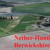
Focused on UK GA and microlight flyers, this FSX rendition of Nether-Huntleywood (grass 07/25, 400 × 45 m, Berwickshire, Scottish Borders) aligns precisely with Playsim’s Scottish VFR terrain, usin…

Roddige Farm Strip supplies a low-key, grass-surface aerodrome update to the England/Staffordshire Microsoft Flight Simulator X map, positioning twin runways 09/27 (440 × 20 m) and 02/20 (340 × 15 …
FSX Beeches-Farm Scenery Update refreshes this Nottinghamshire microlight strip near Newark-on-Trent, aligning it with current UK VFR and model library standards; the grass 10/28 runway (517 × 18 m…
Grange Farm introduces a concise grass microlight strip near Market Rasen, Lincolnshire, to FSX, tuned for Horizon PhotoScenery mesh and autogen, dropping hedgerows, farm outbuildings and crop text…
Bakersfield microlight strip for FSX adds a grass runway in South Yorkshire, tailored for Midland Microlights users yet compatible with default scenery, delivering bespoke hangars, hedgerows, perim…
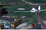
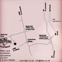
Cockerham Airfield – Patty’s Farm (N53 57.85 W002 50.05) delivers a corrected asphalt runway, revised taxi geometry and supplementary scenery objects for Microsoft Flight Simulator X, matching Hori…
Covering a quiet corner of North Wales, this Microsoft Flight Simulator X scenery places Plassay Strip near Wrexham: a 325 × 8 m grass runway (10/19, 210 ft AMSL) beside Plassey Caravan Park, givin…
Filling a notable gap in FSX coverage, this Bennington Strip scenery update refines the modest grass airfield serving Neil’s Microlights South-East, adding accurate runway contours, revised vegetat…
Designed for FSX pilots running Just Flight/Horizon VFR, this UK add-on plants Breidden and Camphill grass strips into the Peak District and Welsh Borders with custom terrain mesh, environmental au…