Page 3
Searches the whole library — filter by sim & category on the results page
Created by David Dossiere and Mylene Felix, this collection assembles over 800 airline call signs and notes that some ATC callsigns may not work because Microsoft did not include them. It advises u…
By Julien Robert, a grass-improvement option replaces default ground materials with 512x512 image data encoded in DXT3, balancing fidelity and memory use. Alpha blending at edges smooths transition…
Visitors gain the ability to generate additional weather themes and choose them from the program’s weather menu. The work presents a straightforward, creator-credited tool designed to expand atmosp…
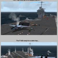
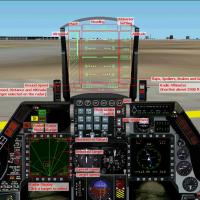
An array of carrier-operation gauges and effects equips military aircraft with catapult-launch capability and cable-trap landings, while a meatball HUD guides precise approaches and a SonicBoom eff…

Rene Konrad develops a utility that installs and uninstalls airplanes without overwriting existing files, and it also manages gauges, sounds, effects, flights, or modules. Version 3.6 introduces a …
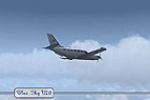
Version 2.0 delivers five sky appearances that cover dawn, morning, day, noon and dusk, aligning with the developer's aim to balance detail and performance by Alex Ranc. Dawn, morning, day, noon an…
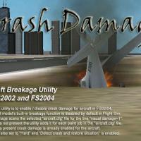
This free utility enables or disables crash damage for any aircraft, with 2005 updates adding high-speed configuration, a larger format, and improved error correction while remaining compatible wit…
Version 1.0, by Stuart Baker, presents a utility that enables adding several resource types via six installers, covering aircraft, gauges, effects, and other components, while offering an option to…
By Gunnar Dähling, this camera tool moves the control tower view using Visual-BASIC and diverges from a freeware concept by introducing modifications to the basic idea. The developer notes it chang…
 Base Model
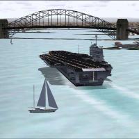
Two models arrive with accompanying panels, forming a compact dual-model setup that includes a basic 2D cockpit. Fletcher Class Destroyer materials by Phil Crowther underpin the build, while Javier…
An Envmap is provided in the DXT3 format and loads quickly, benefiting the flight-simulation experience for enthusiasts and professionals alike. The specification centers on a single format and ass…
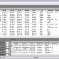
Version 610 expands the AI management toolkit with a new flight plan merge utility, a multiuse flight plan editor, and improved reporting of existing plans. It includes 59 default AI aircraft, 5,50…
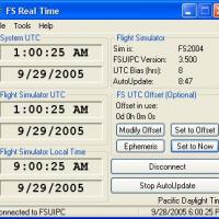
Developed by Joshua Robertson, a UTC time-sync utility keeps time in step with real-world standards, matching the current UTC or applying a +/- offset for varied flight timing. It also incorporates…
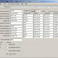
The route editor handles PLN files, letting you edit existing routes or create new ones. It saves routes as VFR or IFR and supports Direct GPS, Low Altitude Airways, High Altitude Airways, and VOR …
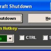
Version 1.3 by Mark Schilberg automatically shuts down aircraft systems when in use, enabling a cold and dark cockpit at startup. It also helps skip manual shutdown after a flight, and supports 200…
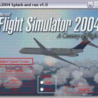
An application lets users select a new splash screen, with a sample image stored as i1gif.JPG referenced in the content, offering a quick, seamless switch for customization. Registration is free an…
 Base Model
On a Waikato carrier operation set, three aircraft variants appear: F14B Tomcat, F16C Viper and F18E Super Hornet paired with F-18G Growler. Two extra paint schemas for the F-18E accompany HUD and …
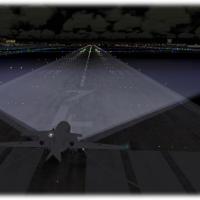
An all-aircraft xenon light enhancement provides a clearer view of the runway and taxiway, improving overall situational awareness during low visibility operations and aiding alignment during appro…
Armando Di Francesco presents a traffic separation tool that controls inbound flows to an airport by configuring minimum separation, desired separation, and a reduced separation zone, aiming to red…
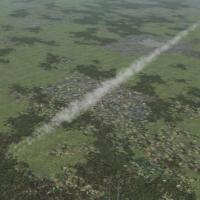
By including three-dimensional contrail visuals, this add-on enhances high altitude flight realism, replacing flat trails with depth. It ships backup files containing the original fx_contrail_l.fx,…