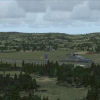
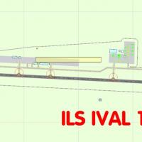
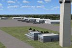
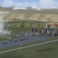
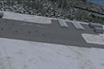
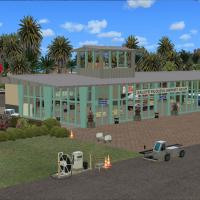
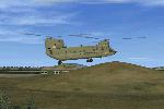
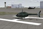
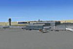
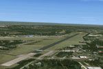
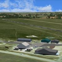
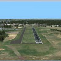
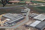
FSX Scenery

Page 111

Sort
Reset
Preview screenshot

Kyusyu AFCAD Series Fukuoka Prefecture

Kasashi Kato presents three variants for Fukuoka Prefecture, Japan, incorporating Fukuoka Airport RJFF and JASDF Ashiya RJFA and Thuiki RJFZ. All three bases carry distinct identifiers RJFF, RJFA, and RJFZ, reflecting geographic scope within the prefecture.

Country
Japan
File Size
553.69 KB
Total Downloads
239
Screenshots
4
Preview screenshot

Molokai Airport

Phillip Coyle provides two BGL files, PHMK_ADE.BGL and PHMK_ADE_CVX.BGL, and uses Airport Design Editor to adjust PHMK near Kaunakakai, Hawaii, refining runway length and width, taxiway connections, and parking positions based on Google Earth coordinates. The offering uses standard objects from the default library and requires a complexity setting to Normal to reveal all elements.

Country
United States of America
File Size
263.52 KB
Total Downloads
239
Star Rating
5/5
Screenshots
1
Preview screenshot

Lillooet Airport

Lillooet Airport (CAR3) in British Columbia appears as an enhanced fictitious depiction by Bob Caparoula, with the file name Lillooet_CAR3.zip and freeware status. The author notes a frame rate freindly design and uses the Mission builder alongside the Abacus shortcut tool.

Country
Canada
File Size
2.17 MB
Total Downloads
239
Star Rating
1/5
Preview screenshot

Dyess AAF Scenery V2

Version 2 adds aprons, parking spaces, taxiways, and other objects, while correcting runway markings at the site. Freeflight International Airport, previously Dyess Army Airfield, sits on Roi-Namur, Kwajalein Atoll in the Marshall Islands, secured an FAA ROI code and operates a 04/22 asphalt runway measuring 4,499 by 150 feet with an elevation of 10 feet.

Country
Marshall Islands
File Size
83.25 KB
Total Downloads
238
Screenshots
2
Preview screenshot

Welzow

Welzow represents a remake of an Ian Elliot design focused on a Soviet-era military airfield in the former GDR used into the early 1990s, with radar by o1399xa and trucks by Hawker appearing among objects.

Country
Germany
File Size
4.72 MB
Total Downloads
238
Screenshots
6
Preview screenshot

Ithaca-Tomkins County Airport

Revisions of Ithaca-Tomkins County Airport (KITH) in New York adjust aprons, taxiways, and roads and add a new terminal with gates and a jetway. The modification replaces the control tower and most default buildings, adds a fire station, assigns airlines to gates, and includes two files named KITH_AFX_JC.bgl and KITH_JC.bgl.

Country
United States of America
File Size
450.61 KB
Total Downloads
237
Screenshots
3
Preview screenshot

Abbotsford International

The project reworks Abbotsford International Airport (CYXX), British Columbia, using ADE v1.39 with satellite imagery; runways 01/19 rise to 5328 ft and 07/25 to 9600 ft, with corrected thresholds and updated VASI. Three BGL variants—CYXX_ADE_RWC.BGL, CYXX_ADE_RWC_CW.BGL, CYXX_ADE_RWC.CVX.BGL—include a CW version that activates Xwind runways, while ATIS may show fake runways on the CW file.

Country
Canada
File Size
715.44 KB
Total Downloads
237
Screenshots
2
Preview screenshot

Williamsport Regional Airport

An enhanced version of Williamsport Regional Airport (KIPT) in Pennsylvania tightens aprons and taxiways, replaces the terminal and most buildings, and adds parking lots, static vehicles, lightpoles, and other filler structures. Two BGL files, KIPT_AFX_JC.bgl and KIPT_JC.bgl, accompany the work, with gates allocated for historical operations.

Country
United States of America
File Size
9.46 KB
Total Downloads
237
Preview screenshot

NL2000 V4.02 De Peel Air Base

EHDP De Peel airfield, credited to The Netherlands 2000 Scenery Design Team, sits in the southeastern Netherlands and integrates with the NL2000 v4.0.20 environment. It adds hangars, flight-line shelters, and precise taxiway lighting to match runway layouts and surrounding terrain.

Country
Netherlands
File Size
50.72 MB
Total Downloads
236
Preview screenshot

NW Washington State Scenery - July 4 Fireworks Project

Two BGL files create displays across Island, San Juan, Skagit, Snohomish, and Whatcom counties, with sites such as Oak Harbor, Friday Harbor, Bellingham, and Anacortes marked for July 3 or 4; some locations show a second file (2). A BglComp.exe tool compiles the data from a Gold package, and an XML reference lists GPS coordinates.

Country
United States of America
File Size
1.11 MB
Total Downloads
236
Screenshots
20
Preview screenshot

Monument Plateau Des Glieres

In the Haute Savoie region of France, a WWII-era site sits at 1440 m elevation and lies about 11 miles from Annecy-Meythet (LFLP) airport, with a course of 77 degrees from runway 04. An optimized version exists for the sim, compatible with Flight Alpes Nord and Nextmesh at 4.75 m, by Alain Robert.

Country
France
File Size
965.42 KB
Total Downloads
236
Screenshots
1
Preview screenshot

Mona Airfield

Mona Field, ICAO EGOQ, sits on Anglesey in Wales and serves as a relief landing ground for RAF Valley. Its history traces to 1915 as a Royal Naval Air Service airship base, and today a civilian flying club and 2474 Cefni ATC operate from the airfield.

Country
United Kingdom
File Size
322.86 KB
Total Downloads
236
Screenshots
1
Preview screenshot

City Place Tower

Dallas hosts a 42-story replica of the downtown tower near Uptown at the I-75 and Haskell Avenue intersection, beneath the flight path of Dallas Love Field runway 31R/13L. The model uses Gmax 1.2 and imagery by Jasc Paint Shop Pro 7.04, free for personal use and may be redistributed in non-commercial projects with credit.

Country
United States of America
File Size
1.23 MB
Total Downloads
236
Preview screenshot

Uetersen Airport

EDHE sits west of Hamburg and hosts several aero clubs, including two glider clubs, while serving as Air Hamburg's base for island shuttle services to Frisian Island and the Baltic islands. Seasonal variations and night lighting accompany the add-on, while the photo background comes from Google Satellite.

Country
Germany
File Size
2.77 MB
Total Downloads
236
Screenshots
5
Preview screenshot

Blackbushe UK Expansion

Blackbushe Airport EGLK receives a fictional UK expansion featuring a 6500-foot Runway 08/26 with a 500-foot displaced threshold and ILS approaches to both ends. A south-side taxiway serves a new apron and terminal with stands for medium jets, while runway markings are provided by Lance Tucker in RWY_MARK.ZIP.

Country
United Kingdom
File Size
841.66 KB
Total Downloads
235
Screenshots
2
Preview screenshot

CYRC - Chicoutimi Airport

Chicoutimi's CYRC depicts a delta-pattern three-runway layout and an NDB approach, with an enhanced apron and parking area housing multiple buildings and nearby wildlife serving as a visual landmark, by Daniel Louvet. Airport information and charts accompany the depiction.

Country
Canada
File Size
4.98 MB
Total Downloads
235
Screenshots
4
No image available.

SDJD SRTM Meshes Correction

Two BGL files correct the altitude at SDJD airport in Jundiai, Brazil, by adjusting the SRTM mesh for the site. CVXSDJD.BGL and APX35400.BGL are included, and the original APX35400.BGL must be backed up prior to replacement in directory 0405 by Cesar Marinho.

Country
Brazil
File Size
37.79 KB
Total Downloads
235
Preview screenshot

Perth/Scone

Perth/Scone in the United Kingdom gains a fictional airfield expansion, extending Runway 03/21 to 4500 feet with 1500-foot TDZ markings. A new small terminal at the 03 threshold serves BAe146-size traffic, GA areas are tidied, and static aircraft and trees are added around the airfield; four EGPT_ADEX files accompany the change for EGPN Perth.

Country
United Kingdom
File Size
4.22 MB
Total Downloads
234
Star Rating
5/5
Screenshots
20
No image available.

Albertville

Stephane Gouzon authored LFBS, v1.0, and crafted it with ADE, SbuilderX, and Whisplacer. The LFBS - Biscarrosse folder anchors the Biscarrosse airfield location 65 km southwest of Bordeaux in Aquitaine, near Biscarrosse-Plage on the Atlantic coast.

Country
France
File Size
10.38 MB
Total Downloads
234
Preview screenshot

Comox Valley

Comox Valley (CYQQ) in British Columbia, Canada, receives a rework by Daniel Louvet that adds taxiway signage for improved airport mobility and re-centers the ILS to reflect a non-offset configuration. Additional airports listed include CZBB Boundary Bay, CYCD Nanaimo, and CYCZ Fairmont Hot Springs.

Country
Canada
File Size
60.58 KB
Total Downloads
234
Screenshots
1