Page 33
Searches the whole library — filter by sim & category on the results page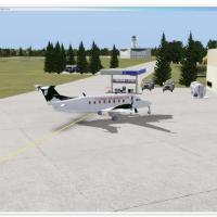
CYAZ in British Columbia gains a missing control tower and enhanced parking, including a SAR helipad station, by Daniel Louvet, while float planes and very small passenger aircraft operate there; a…
 Canada
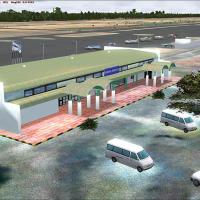
Version 2 brings custom airport buildings and an elevation fix with corrected airport layout for Kasane FBKE. Windsock headings and tower view are corrected, and a freeway traffic exclusion protect…
 Botswana
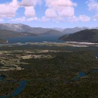
By Douglas Keech, this add-on covers Kitimat/Terrance from Sioux Channel to Kalum Lake, with the Kitimat, Skeena, and Kalum rivers. Terrain data use ~21 meter resolution with multi-LOD; two airport…
Canada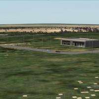
An airport enhancement by Cesar Marinho improves details for Prefeito Octavio de Almeida Neves Airport (SNJR) in Brazil. It remains free and available to anyone or any site, yet commercial sale rem…
 Brazil
MMMY in Monterrey, Mexico, receives a fix that corrects an ILS alignment problem at the field, addressing approach guidance with a FlyMex add-on. The adjustment centers on the ILS, and the provider…
 Mexico
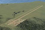
The addon depicts RAF Friston and Newhaven Harbour in East Sussex, England, assembled from four BGL files stored in the fstnnhvn folder. Airport Design Editor guides the layout and EZ-Landclass Ver…
 United Kingdom
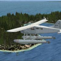
Three fictional water airports operate in the Stockholm Archipelago, including Hallonstenarna (ESHS), Forsvik (ESFK), and Singo (ESSS). Files with the .bgl extension carry unique registrations for …
 Sweden
By Daniel Louvet, the CZBB airstrip in British Columbia sits two nautical miles from CYVR and presents a relocated ground footprint with buildings, fuel tanks, parking areas, flight schools, GA air…
Canada
The L51 site in Death Valley hosts the Aeroworks ARX-6 Reno racer for low-altitude testing and features the world’s lowest Formula 1 course. Since the ARX-6 release, the location serves as a desert…
 United States of America
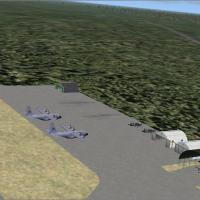
Andres Ramirez authors Apiay in Colombia, presenting an aerial view of the area that highlights its geographic context and local features. Two image files accompany the presentation, Apiay-Colombia…
 Colombia
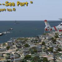
Two airfields exist—one grass for small private planes, one concrete for commercial traffic—plus a floatplane base and a lighted helicopter pad at the port hospital. All .BGL files go into the Addo…
Canada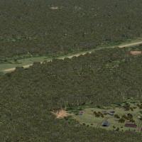
Dominique M. L. Donzelot presents the SOOS airstrip in the Guyana jungle, about 110 miles south of Cayenne, where terrain restricts operations and landing on 21 is prohibited when 03 is unavailable…
 French Guiana
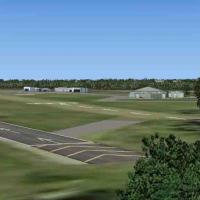
Flensburg-Schaeferhaus (EDXF) sits in Schleswig-Holstein, Germany, as the northernmost mainland airport near the Danish border, a distinctive position stated in its description. The remake reflects…
 Germany
An airfield enhancement for Dax Seyresse (LFBY) in France arrives as version 1.0, tested with SP2 Acceleration and UTX Europe, by Stéphane Gouzon. It centers on the Dax commune in Landes and the Aq…
 France
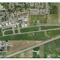
Chilliwack airport (CYCW) in British Columbia receives a focused enhancement that adds maintenance parking and buildings missing from the default, with updates to runway 06/24 and a helipad. Credit…
Canada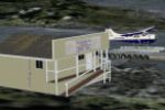
Gold River Water Aerodrome CAU6, a public float base at the head of Muchalat Inlet, receives a custom-objects enhancement by Mike Mann designed for the Blue Pacific Northwest package, and includes …
Canada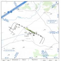
An airfield labeled LFNL sits about 20 miles north of Montpellier in southern France and serves the local glider club. It uses existing objects, stays small in size, and minimizes FPS impact, while…
FranceKRST in Minnesota receives corrections to gates, numbers, and codes, a fix credited to Dusty Bizub as his 19th airport. Dusty Bizub is listed as the author, and the note references additional airpo…
United States of America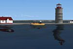
Two lighthouses anchor the area, Haut-Fond-Prince and Ile Rouge lighthouse and buildings, near Tadoussac, Quebec, in a maritime VFR presentation by Jean-Pierre Fillion. Four original ships—Famille …
Canada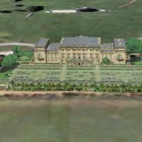
Part of the Castles and Halls series, Harewood House sits near Leeds, UK, with a 2.4m/pixel terrain mesh at 5m/pixel resolution and coordinates N53*53.85, W1*31.59. Built 1759–1771, grounds are by …
United Kingdom