Page 34
Searches the whole library — filter by sim & category on the results page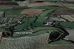
Near Canterbury in Essex, Clipgate Farm lies, and Pent Farm sits a few miles away on a downhill north–south strip with a steep approach to 24 and an unforgiving end ditch. Two new sounds accompany …
 United Kingdom
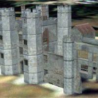
Located near Fareham, Hampshire, England, Titchfield Abbey appears as a ruin created by Simon Swallow. All models are built with GMAX, and the directory is named Titchfiled Abbey for placement in t…
United Kingdom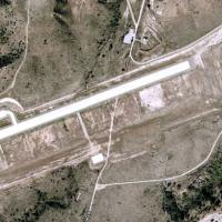
By Michael Mannschreck, the airfield sits in the California mountains inland from the coast, about 53 nm from KLAX and 12 nm from KNFG, and includes runway 4/22 with taxiways and turn-around points…
 United States of America
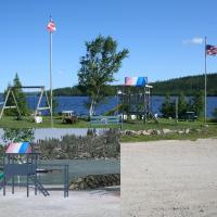
Gouin dam, ICAO CTP3, is a waterdrome located north of La Tuque in Quebec, Canada. The area includes the L'Aventurier du Gouin outfitter at ICAO CB31 near coordinates N48°34′45″ W74°32′50″, and has…
 Canada
Near Barcelona, Spain, Odena is a small private airfield, paired with a lightweight addition to LEIG that enhances the Barcelona Igualada area's visual appearance. By Juan C. Chavez Dominguez, it u…
 Spain
Spain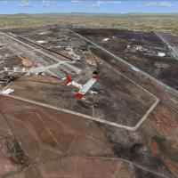
Sunay Kilic presents a Konya LTAN layout in central Anatolia, tailored for VFR operations and enhanced with autogen and photoreal components. It reflects NATO use as a low-level exercise and Awacs …
 Turkey
Anwar Gonzalez presents the ZUJZ airfield near Songpan, Sichuan, China, with airport buildings and working jetways, and autogen corrected to remove trees inside the airport limits. Elevation reache…
 China
China
EGNC Carlisle by Tony Meredith includes Carlisle EGNC.bgl with airfield data and cvxCarlisle.bgl to flatten the airfield into photo imagery, plus two supplementary BGL files. The package references…
United Kingdom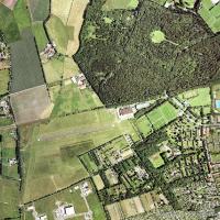
Neumuenster airfield (EDHN) sits in Schleswig-Holstein, northern Germany, a small aeroclub field near the Kiel autobahn. By Uwe Schweitzer, it stands as a modified version of the former EDHN VFR la…
 Germany
Two images by Andres Ramirez document the Guapi airfield in Colombia, depicting a plane taking off in one frame and a broad view of the area in the other, providing a concise, on-site impression fo…
 Colombia
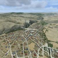
Sunay Kilic provides is-LTIN.bgl, a small fix that removes thermals over LTIN Inonu airfield and nearby Inonu city, reducing interference with autogen houses and smoothing glider landings. The modi…
Turkey
Secunda Airfield (FASC) in South Africa presents a detailed depiction, with the Sasol plant to the south. Its geographic reference centers the airfield against an industrial landmark and clarifies …
 South Africa
Neil Birch delivers a ten-field extension, including Egton and Fishburn, aligned with VFR materials. It requires ADOTF.ZIP, ADOTF-UP.ZIP, ADFARM-2.ZIP, WDYEZSRP.ZIP, plus Rwy12 and UK VFR add-ons, …
United Kingdom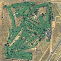
Two public airports in California anchor this listing: Yuba County (MYV/KMYV) near Marysville and Oroville Municipal (OVE/KOVE) near Oroville, each with two runways; Oroville spans 920 acres and fe…
United States of America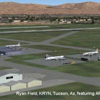
John B. Loney, Jr. provides a compatibility revision for Ryan Field at KRYN, near Tucson, Arizona, based on the original KRYN_V1.ZIP layout. A subsequent file facilitates operation with a newer pla…
United States of America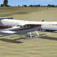
An addition to a private seaplane base in Frostproof, Florida, identified as FD46, uses ADE 1.50 and features docks along with ADF and VOR frequencies. Coordinates N27°45.32', W81°30.84', elevation…
United States of America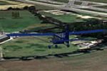
Vallance By-Ways Gatwick is No. 12 in a grass-strip series and centers on a field near Gatwick, referencing Gatwick Aviation Museum with aircraft such as Avro Shackleton and Ercoupe from the 1930s.…
United KingdomPrinceton Airport (39N) in New Jersey sits on 100 acres as a public airstrip with five hangars accessible via DOCK parking, including north Docks 16–17, central Dock 20, and south Docks 18–19; fuel…
United States of America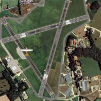
Haverfordwest airfield, licenced and operated by Pembrokeshire County Council, sits at N51 50.02, W004 57.63. This variant aligns topography with high‑resolution photo data, requires Horizon GenX P…
United Kingdom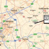
Near the town of Amougies in Belgium lies the EBAM airstrip, about 610 meters long and 22 meters wide, with two elevation options delivered as bgl files, depending on standard layouts or a custom B…
 Belgium