Page 48
Searches the whole library — filter by sim & category on the results page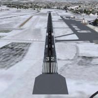
Bern Belp (LSZB) extends its runway to 1730 meters, upgrades ILS14, adds taxiway designators K and G, introduces helipads, and updates apron design, lighting, and taxiway signs, while SHU and MUR N…
 Switzerland
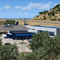
Flores Airport, LPFL, located in the Azores Islands of Portugal, appears in a version 2 edition by Lets Fly Association and Shigeru Tomino. The edition centers on the Flores facility within its geo…
 Portugal
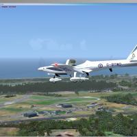
Two aircraft folders populate RAF Woodvale EGOW: Grob115 hosts Dave Garwood's Grob Tutor and Andy Nott's two university paints, while Grob Vigilant contains Bob May's Vigilant motor glider. The set…
 United Kingdom
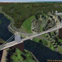
UK, v1.0 provides static objects for a bridge and observatory placed near Bristol, England, integrated with the ORBX EU England regional addon. It includes a placement file to position these struct…
United Kingdom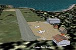
By John B. Loney, Jr., this rendering draws from the author's AK series and covers twenty Alaskan airports, including English Bay (KEB) and Minchumina (PAMH). Fort Yukon (PFYU), Boswell Bay (AK97),…
 United States of America
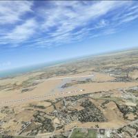
UBBB, Heydar Aliyev International Airport near Baku, Azerbaijan, gains a version that fixes jetway disconnections caused by ADE not loading JFK Jetway models prior to compilation and straightens th…
 Azerbaijan
Richard Sorochak offers a photoreal depiction of Kauai, Hawaii, organized under the folder The Hawaiian Islands - Kauai, with faithful island textures. The collection includes two image files and a…
United States of America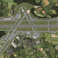
By Junior Moult, this expansion for Newquay Airport incorporates the disused southwest portion and a northern representation of RAF St. Eval. Four EGDG_ADEX files populate the main addon directory,…
United Kingdom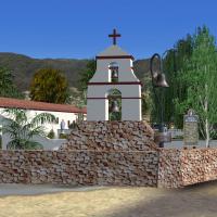
Ron Ezra credits eleven of the twenty-two Spanish sites, including San Diego, Carmel, San Antonio, San Juan Capistrano, Santa Barbara, Soledad, San Juan Bautista, San Miguel, San Fernando, San Luis…
United States of America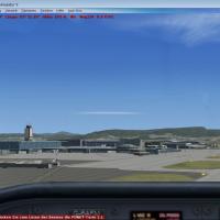
By Othmar Egli, Basel-Mulhouse-Freiburg (LFSB) in France appears as a work-in-progress attempt to reproduce the airport in a simulation context. Two preview images fsx1.jpg and fsx2.jpg illustrate …
 France
The facility at LEMD in Spain gains a new taxiway and longer runways across all four to better accommodate takeoffs and landings. An associated file named AFX_LEMD records the change for implementa…
 Spain
Spain
Joost Visser delivers an add-on that places about 60 ships along the English Channel, including cargo vessels, containerships, super tankers, and cruise liners. It uses ADE 1.37 and relies on a fic…
 Global (World)
Juergen Seidel builds Abu Dhabi airport (OMAA) using Gmax and Scen Gen X, and adds night lighting with hangars that have opening doors. The abudhabi folder handles integration, and Freeware status …
 United Arab Emirates
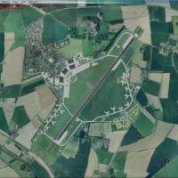
Two variants exist for this RAF Coltishall representation, designed for different base configurations, and two C130 Hercules plus five SEPECAT Jaguars appear around the hangar area. The airfield re…
United Kingdom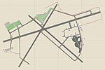
Jim Cook presents a KNQX upgrade for Key West, Florida, reworking the NAS airfield by removing certain stock buildings and adding military cargo parking, additional pavement, and static vehicles, w…
United States of America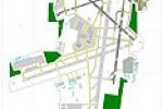
ADE 9x drives an overhaul of the base layout, refines the arrangement, and slightly extends Runway 01R/19L, while staying essentially aligned with the real Milwaukee airport in Wisconsin. John Ball…
United States of America
Lebanon Terrain X v1.0 strengthens elevation, coastline, water class, and regional land use, while adding moving traffic to major roads across the country. The distribution comprises four folders, …
 Lebanon
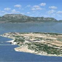
Aeroworx delivers a detailed coastal depiction of Robben Island off Cape Town, led by Hannes Steyn and Martin du Preez with support from Johan van Wyk. A 1m-resolution terrain mesh optimizes elevat…
 South Africa
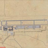
KTNX sits in Nevada, 27 NM southeast of Tonopah. The airfield features a 12,000-foot runway, instrument approach facilities, nighttime illumination, and a straightforward layout that supports opera…
United States of America
Pudong International Airport (ZSPD) in Shanghai gains terminals 1 and 2 and a new 17R/35L runway, with updated taxiways, taxi signs, and rebuilt support roads. Three BGL files govern the changes: Z…
 China
China