Page 47
Searches the whole library — filter by sim & category on the results page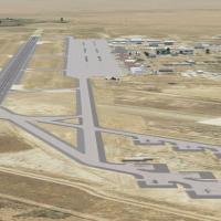
Mountain Home AFB (KMUO) in Idaho centers on three F-15 squadrons and a Singapore F-15 under the 366th Fighter Wing, with the 266th RANS maintaining Saylor Creek and Juniper Butte ranges. Two new V…
 United States of America
NL2000 v4.02 EHRD edition covers Rotterdam The Hague Airport, with terminal structures, hangars, and precise layouts anchored in southwestern Netherlands. It blends surrounding highways and city bl…
 Netherlands
Version two expansion adds about 650 square kilometers of photoreal coverage around LESU and LECD in Spain, and corrects both airfields. Authored by Andy Aundrias and requires ANDORRA-FSX.ZIP to op…
 Andorra
Two available screenshots document Milford Sound airstrip (NZMF) in New Zealand, credited to Lets Fly Association and Shigeru Tomino. They originate from two image references that present the site …
 New Zealand
Three parts labeled 1, 2 and 3 focus on forest visuals at 50 cm resolution, spanning global coverage, by Aime Leclercq. BMP files listed also include 022b2....bmp, 022c2....bmp, 023b2....bmp, 024b2…
 Global (World)
By Anwar Gonzalez, the Pereira, Colombia project aligns with IATA PEI and ICAO SKPE, and a 2,020-meter asphalt runway 08/26. ADEX and AFX files specify the current runway direction and airport buil…
 Colombia
By Thomas Schlechter, this first version for Dusseldorf International at EDDL adds gates V91–V96 (6), V86 (1), V61–V74 (10), V53–V31 (9), and V29–V01 (10), plus two GA parking spots and parking cod…
 Germany
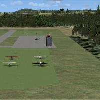
Forty-one Swiss airfields and bases gain enhancements, including expanded parking, taxiways, night lighting, control towers, and tower frequencies. BR2_ICAO.bgl files are included and usable with o…
 Switzerland
John Stinstrom continues the project that trains Navy aviators at Meridian KNMM in Mississippi using the T-45 Goshawk to practice carrier landings. He collaborates with Jim Dhaenens on a native ins…
United States of America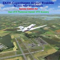
Jens Peter Bruun-Hansen presents a satellite-imagery refinement of EKRK-Copenhagen Airport Roskilde, delivering a precise aerodrome layout that blends with the surrounding terrain. It requires the …
 Denmark
Marc-Henri Guitteny delivers a Nantes-ville addon that adds a new local mesh and photoreal imagery at 2 m/pixel, along with various buildings, churches, and reference marks. A touristic map resides…
 France
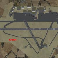
For EGGD UK, the Bristol aerodrome update introduces satellite imagery, certified NAT maps, and the new terminal complex. It is built with ADE9x, uses GMax created objects alongside default element…
 United Kingdom
Two BGL options update Christchurch's NZCH airport for the default layout, with NZCH_ADE_CW_RS.BGL activating the Xwind runway and NZCH_ADE_RS.BGL lacking parking; both incorporate updated taxiways…
New Zealand
Version 2.0 adds docks, jetways, an extended runway, taxiways, and new taxi signs, and corrects the location, including a Myanmar Air Force area with helipads and expanded civilian parking. Full tr…
 Myanmar
Across twenty eastern Caribbean airports, this installment, created by Chris Carel, expands the seaplane network with sea-plane docks and navigational aids across multiple islands. It pairs with ea…
Global (World)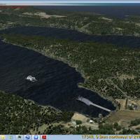
Version 1.0 introduces five ferries from the BC Ferries fleet scattered along coastal routes, supported by a static library of five BC Ferries objects for placement. It covers 47 ports of call on 2…
 Canada
Bern Belp (LSZB) extends its runway to 1730 meters, upgrades ILS14, adds taxiway designators K and G, introduces helipads, and updates apron design, lighting, and taxiway signs, while SHU and MUR N…
SwitzerlandUsing 3ds Max from scratch, it presents accurate buildings, hangars, and parking bays with night lighting. The model includes static aircraft and animations and uses photo-real terrain, and the air…
 Bangladesh
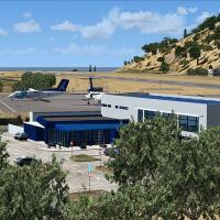
Flores Airport, LPFL, located in the Azores Islands of Portugal, appears in a version 2 edition by Lets Fly Association and Shigeru Tomino. The edition centers on the Flores facility within its geo…
 Portugal
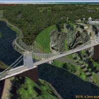
UK, v1.0 provides static objects for a bridge and observatory placed near Bristol, England, integrated with the ORBX EU England regional addon. It includes a placement file to position these struct…
United Kingdom