Page 50
Searches the whole library — filter by sim & category on the results page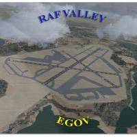
By Gordon Barnes, the RAF Valley layout (EGOV) on Anglesey, North Wales, appears as it did in 2010. It covers Hawk T1 jet training for 19 Squadron and 208 Squadron, while taxiways and building posi…
 United Kingdom
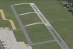
An add-on by HOUSE-RP for EDDN Nurnberg in Germany replaces the concrete runways and taxiways with a mixed real layout and corrects taxiway paths so AI traffic can reach the gates. The change uses …
 Germany
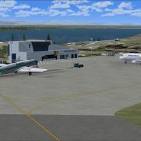
Deline, Tulita, Norman Wells and Fort Good Hope airports are included, and the project is completely redesigned from scratch with custom models and visuals by Frits Beyer and Jacques Botha. It work…
 Canada
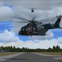
Portions of taxiways at the real-world Bagram AFB (OAIX) gain concrete widening in the Version 3 revision. The process requires prior installation of bagram_ver_3.zip; it replaces OAIX_ADEX_DM.BGL …
 Afghanistan
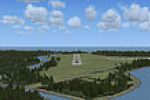
Hay River, CYHY in the Northwest Territories sits on the southern shore of Great Slave Lake, and the layout aligns the airport with NAV Aids. GMax-built buildings use photographic imagery, while st…
Canada
KMHT, Manchester, NH, offers three BGL files: KMHT_ADE_RS.BGL, KMHT_ADE_CW_RS.BGL, and KMHT_ADE_OBJ.BGL, with KMHT_ADE_CW_RS.BGL activating the crosswind runway and KMHT_ADE_RS.BGL mirroring defaul…
 United States of America
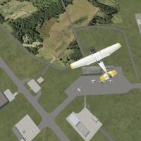
Hasanuddin Airport (WAAA) in Makasar, Indonesia, becomes a replacement that features more accurate aprons and parking and is developed by Er-Jin Jang. The airport's facilities align along a taxiway…
 Indonesia
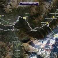
A mountain hut sits in the French Alps near Mont Blanc and offers two variants: the original structure and a second version with a helipad. Created by Manolo Dobrazil, the hut remains in an alpine …
 France
Lee Marrow presents a detailed modification of George Bush Intercontinental Airport (KIAH) in Houston, upgrading cargo facilities, ramp activity, and parking layouts, while a traffic configuration …
United States of America
An add-on expands Namibia with 207 airfields and landmarks across diverse regions, and uses ADE X v1.5 for precise runway placement. A companion NAMIBIA_AIRPORTS_UPDATE_1.ZIP provides refinements, …
 Namibia
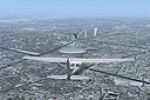
Version 1.0 for Montreal VFR opens in Quebec, Canada, and adds the Olympic pyraminds, a cross on the Royal Mountain, locks of St-Lambert, and roads on the Royal Mountain, enhancing visual landmarks…
Canada
LFQK airfield near Chalons-en-Champagne anchors the layout, providing access to a photoreal ground that includes seasonal and night variants. A VAC_LFQK.pdf approach chart accompanies the work, ens…
France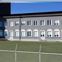
Stas Neznamov presents Estonia's EETN airfield in version 1.0, manually programming it with Cartesian coordinates baisX/baisZ to define the layout. The result covers the Tallinn area with a focus o…
 Estonia
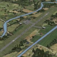
By Geoff Steiner-Scott, this Irish airfield enhancement adds Abbeyshrule, Bantry, Birr, Clonbullogue, Coonagh, Kilrush, Letterkenny, Moyne, Rathcoole, Spanish Point and Trim aerodromes, with Munste…
 Ireland
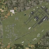
Two BGL files, KIND_ADEX_CJH.BGL and KIND_ADEX_CJH_CVX.BGL, implement corrected ILS alignments for Indianapolis International Airport (KIND) and add GPS-style graphics for the approaches, with all …
United States of America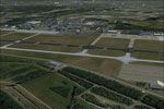
Designed for NL2000 v4 by NL2000 contributors, the Eindhoven Airport (EHEH) module emphasizes accurate taxiways, aprons, and gate positions, with refined terminal facilities. It also updates ground…
 Netherlands
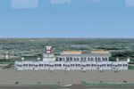
By Huseyin Buharali, the creator uses 3ds Max to build this project from scratch, depicting the busiest airport in Bangladesh with accurate terminal silhouettes, hangars, and parking bays at night.…
 Bangladesh
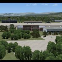
Petropavlovsk-Kamchatsky Airport in Kamchatsky, Russia, is created by Jacques Botha, relies on default library resources, and includes a layout file derived from Google Earth. The layout file is de…
 Russian Federation
Two-airport pair includes Zweibrucken (EDRZ) and Pirmasens (EDRP); it uses stock and freeware objects and is optimized for VFR Germany. The design relies on Airport Design Editor 9_147, with freewa…
Germany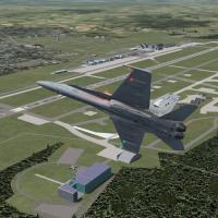
In the second edition expands Misawa AB in Japan, tripling the area and adding hangars, terminals, the main gate, the nine-story residences, and the FLR-9 antenna with Echelon radomes. Most models …
 Japan
Japan