Page 5
Searches the whole library — filter by sim & category on the results page
Jeppeson2001 delivers a Bryce Canyon area expansion, organized into three regions represented by folders BryceCanyon_FairylandPoint, BryceCanyon_InspirationPoint, and BryceCanyon_RainbowPoint. The …
 United States of America
By Thalixte, a drop-in replacement for the Charlotte area provides photogrammetry and detailed 3D models of buildings and landmarks. It partitions the region into five named zones—Downtown, East, N…
United States of America
Developers replace the Rotterdam region's ground surface and terrain elevation with higher-detail data sourced externally and add 3D building data for a denser urban layout, while the release spans…
 Netherlands
Cholila Lodge Aero Fishing is a private aerodrome in Patagonia, a rework located 15 km from Cholila, by Hernan Di Tano. It includes 3D custom objects, GA parking, a reworked runway and terrain, and…
 Argentina
ZKPY, the DPRK's main airfield in Sunan district, receives a hand-built rework by Kui to reflect 2021 appearances, including a terminal built from scratch with three jetway gates and two parking ga…
 Korea (Democratic People's Republic of)
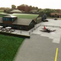
Near Windschoten in Groningen, Netherlands, one grass runway and two taxiways define this small airfield created by Ruben. All 3D objects are built in Blender and exported for freeware use, and the…
Netherlands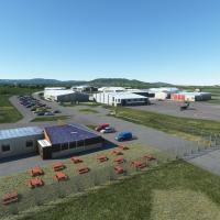
Near Gloucester and Cheltenham in the UK, this add-on recreates Gloucestershire Airport with forty custom hangar models reflecting the real layout. It centers on active runways 09/27 and 04/22, not…
 United Kingdom
Avaldesign presents a private airfield in the Guadalajara region of Spain, ICAO LERM. The asphalt runway 01/19 measures 1000 by 18 meters, and the arrangement conveys clear proportions and real-wor…
 Spain
Spain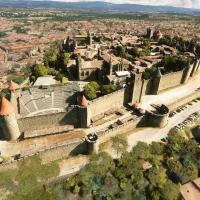
Photogrammetry delivers an exact digital duplicate of Carcassonne, including its medieval fortress, with detailed fidelity from the citadel outward. Version 1.1 includes a critical update that reso…
 France
Nearby Linden Airport, designated KLDJ, receives a freeware recreation by demonicdave that reworks most of the field, adds perimeter fences, and places extra vehicles around the airfield to better …
United States of America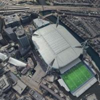
Two folders named thalixte-cardiff1 and thalixte-cardiff2 exist, and the work uses photogrammetry and depth data to render Cardiff's city layout with improved realism. Cardiff Airport EGFF and St A…
United Kingdom
Located in Papua New Guinea, Simogu AYQM is a grass/dirt strip 510 meters long with a 7.5% slope at around 4,800 feet, though the sim places it about 200 feet higher due to limitations. West of Gem…
 Papua New Guinea
Owena airstrip AYWW in PNG presents a 1000-foot dirt runway with gradients from 13% at the midsection to 17% at the top, and the approach is advised from the west due to surrounding terrain. A blen…
Papua New Guinea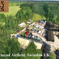
Lotmead Airstrip near Swindon, UK carries the GB085 designation as a private grass strip with no commercial traffic. The download ships with required models, and Neil Birch's other farm strips shar…
United Kingdom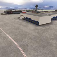
by artogsta, ENTC Langnes Airport spans both 2020 and 2024 iterations, adds animated jetways at gates 18–20, and introduces Parking 55–57 aligned to AIRAC data. The 3D model emphasizes improved ter…
 Norway
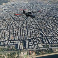
An add-on recreates Thessaloniki with authentic photogrammetry derived from Google Maps data, processed using the Google Earth Decoder tool to render 3D city details like the White Tower and port. …
 Greece
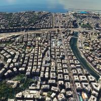
Genoa photogrammetry addon renders accurate topography and three-dimensional structures over the Ligurian city, using photographic data to capture harbor details and historic landmarks. Version 1.2…
 Italy
Italy
Brighton City Airport presents a faithful layout with one paved runway and three grass strips. The project centers on the file named brightoncityairport-shoreham-egka-mkvy and uses the Sim Update 7…
United Kingdom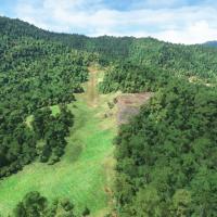
Gema Airstrip AYGM in Papua New Guinea, by Photosbykev, features a dirt runway with a long steep upslope and an ICAO code, complemented by custom objects and hand-placed buildings. The project cite…
Papua New Guinea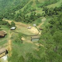
Aziana airstrip with code AYLA in Papua New Guinea measures 975 feet as a dirt strip with an 18–20% upslope. Terrain around is hand-modified and terraformed to reflect real-world features, with the…
Papua New Guinea