Page 72
Searches the whole library — filter by sim & category on the results page
Eliza Island marks the fifth volume by designer David Roch, centering on avian activity near Orcas Island. The set includes a BGL-based element and relies on advanced animations to display birds, d…
 United States of America
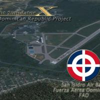
San Isidro base carries IATA ZXD and ICAO MDSI and appears as Vol. 1, locating about 25 miles east of Santo Domingo. Origin traces to 1953, when it operated under the name Trujillo until 1961, with…
 Dominican Republic
In Maine, Bangor International Airport gains an improved layout with adjusted aprons, taxiways, and roads, plus GA parking and military cargo and combat parking at Air National Guard apron, moved b…
United States of America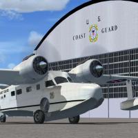
Version 1.0 centers the field at Floyd Bennett and Coast Guard Air Station Brooklyn, depicting the 1938–1941 transition with runways modeled at maximum lengths and the terminal rendered in a 1931–1…
United States of America
Located on the Turkish coast near the sea, Selcuk-Efes airfield (LTFB) presents coordinates N 37.57'08", E 27.20'00", elevation 15 ft, with NDB 424.00 and Tower 131.00. By Dominique M. L. Donzelot,…
 Turkey
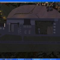
Terminal A adds five jetway-equipped gates and thirteen off-gate ramps, while Terminal B receives updated assignments and an expanded Luxair Cargo Center with eight Z ramps. Taxiway D1 and D2 repla…
 Luxembourg
Kevin R Wynn presents a non-animated 3D depiction of the Disneyland monorail in California, drawing on a model provided by Peter Olsen and credited to both Olsen and Wynn for the Disneyland monorai…
United States of America
An enhanced version adds Military_Cargo and Military_Combat parking spaces, alongside commercial and GA areas, and tightens taxiways and aprons. Two BGL files, AFX_KYUM_JC.bgl and KYUM_JC.bgl, acco…
United States of America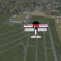
Crafted by Roger Leupold, Parafield aerodrome aligns runway layouts and adjacent structures using Google Earth references to mirror airport geometry, with hangars and terminal areas distributed to …
 Australia
Jean-Claude Irle develops a Millau Viaduct scene using SDK-SP2 and GMAX, with three dedicated folders PontMillau_Routes, PontMillauExclude_Trafic, PontMillauViaduc and an Effects directory. Optimiz…
 France
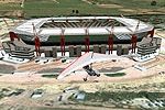
In Nelspruit, the Mbombela Stadium replica is freeware and built for the 2010 FIFA World Cup hosted in South Africa. Philip Schall of PSDS creates it from a custom designed object with a photoreal …
 South Africa
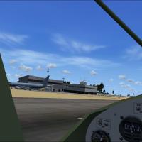
An early freeware addition brings populated details to Nauru's shores, adding buildings, cars, and people across the island. It is the first and only such upgrade for the platform, and notes the is…
 Nauru
Nauru
The project centers on Millville Municipal Airport (KMIV) and the Wheels and Wings gathering, anchored by David Schultz Airshows LLC, with a lineup that includes Blue Angels, Thunderbirds, Snowbird…
United States of America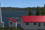
Eighteen lighthouses line the Pacific Northwest coast of British Columbia, each staffed by the Canadian Coast Guard and featuring a helipad linked to real-world locations. Flights begin at every he…
 Canada
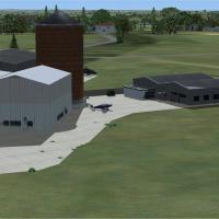
By Alf Denham, three UK aerodromes receive placement refinements including Maypole (EGHB) near Kent, a grass-strip with improved hangar layout, Seething (EGSJ) in Norfolk with more precise markings…
 United Kingdom
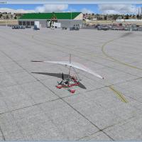
Eric Cagan presents a KEKO_Elko_FSX upgrade for the sim, including updated libraries library_parking_lots_large_ss_FSX and parking_ss_FSX, plus RampLightLibrary and lightobj, with an ADE file inclu…
United States of America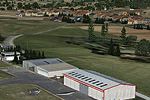
Bar-le-Duc near Verdun presents LFEU visuals with hi-res photoreal ground, seasonal and night variants, and a bumpy, sloped runway. It includes 33 animated wind turbines, a 3D village with cars and…
France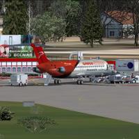
Ciudad Bolivar City in southern Venezuela serves as the geographic focus of this add-on, which features a terminal building, control tower, fire station, and heliports with detailed visuals. It is …
 Venezuela (Bolivarian Republic of)
Ronan Kyne compiles version 1.00, covering eight Irish airfields such as Weston EIWT and Sligo EISG. Birr EIBR, Galway EICM, Connamarra EICA, Inis Mean EIMN, Iniseer EIIR, and Waterford EIWF appear…
 Ireland
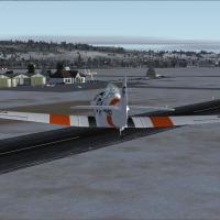
The Pontarlier airfield sits in Franche-Comté, near the Swiss border, and serves general aviation with ULM activity. Not compatible with earlier versions, it shows a single runway instead of the tw…
France