Page 87
Searches the whole library — filter by sim & category on the results page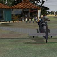
An island group in the Bay of Bengal receives enhancements with four new airfields and landclass updates across main towns; a naval base allows helicopter landings on a destroyer by the bay. Six fl…
 India
India
At KISP in Islip, New York, a complete new terminal and tower rise, with gates corrected for Southwest Airlines and US Airways and jetways visible and operable via CNTRL-J. Made using ADE, the work…
 United States of America
Kim Barreto provides a fix at TNCM in the Netherlands Antilles that corrects the ILS glideslope for runway 9 and works with TNCMMODS.ZIP. The adjustment replaces the prior data via a single BGL fil…
 Sint Maarten (Dutch part)
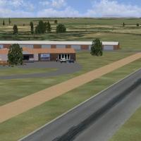
Located near Pretoria in South Africa, Aeropark Zynkraal serves a GA training airfield for local pilots. It emphasizes a dedicated FAZK area and references the AFX_FAZK_ALT.bgl, both guiding start …
 South Africa
Two configurations accompany this Palermo LICJ offering, with separate BGLs for default runway operations and crosswind activation (LICJ_ADE_RS.BGL and LICJ_ADE_CW_RS.BGL). A dedicated LICJ_ADE_OBJ…
 Italy
ItalyBy Tim, three offshore platforms appear in version 2.0, featuring updated ships and a revised file structure, and VORs are provided for each platform and its carrier. Each facility connects to an a…
United States of America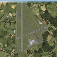
Two BGL files, authored by Paul Lintott, modify Lasham Airfield (EGHL) in the UK, overwriting the standard layout. They place old Dan Air hangars and scattered aircraft around the field to enhance …
 United Kingdom
Oceana carrier formation v4.0 sits 12 NM northeast of Oceana NAS and consists of carriers, cruisers, and destroyers. Each carrier hosts an NDB at 401.0 kHz with 100 NM range, a VOR-IDENT OCG, and L…
United States of America
At Honolulu, the Battlestar Galactica fleet appears with named units such as FLATTOP, CLOUD9, and COLONIAL1 listed alongside others. The BSG_Fleet.bgl file functions as a library object, enabling p…
United States of America
By Peter Dooley and Johan van Wyk, this FAHG project models Heidelberg's airfield southeast of Johannesburg, with adjusted elevations and precise structures that reflect local terrain. It relies on…
South Africa
Phillip Coyle presents Hana Airport (PHHN) in Hawaii with two BGL files, PHHN_ADE.BGL and PHHN_ADE_CVX.BGL, compiled using Airport Design Editor to refine runway lengths and taxiway alignments base…
United States of America
An improved NAS Mayport presentation (KNRB) in Florida adds military parking, a replaced fire station with trucks, and adjusted taxiways per Google Earth. Files AFX_KNRB_JC.bgl and KNRB_JC.bgl supp…
United States of America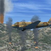
Across Montserrat’s southwest coast, Blackburne—also known as W. H. Bramble Airport—appears as destroyed after the 25 June 1997 eruption of Soufriere Hills near Plymouth. Volcanic effects show ash …
 Montserrat
By Kevin Ball, the layout maps Telecom Tower near Leeds Bradford Airport, UK, BT Tower near EGNM, and Menwith Hill golfballs across Yorkshire and Lancashire, including two Huddersfield objects and …
United KingdomThree FIR boundary points PETOV and TISKO/OBUTI, plus a marker west at LJLJ, appear in a .bgl file within the LJLA-Slovenia FIR, enabling published procedures and missed approaches for runway 31. A…
 Slovenia
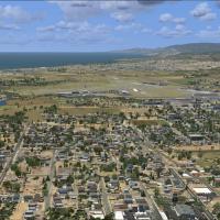
Santa Barbara area landclass expansion adds hundreds of objects to mirror the real layout around UCSB, Goleta, Santa Barbara and Montecito, with airport-adjacent buildings aligned to Google Earth r…
United States of America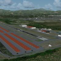
Metropolitano Airport (SVMP) in Venezuela sits near Ocumare del Tuy with a 1400-meter runway and phototerrain derived from satellite imagery. The layout includes a terminal, control tower, hangars …
 Venezuela (Bolivarian Republic of)
By Devin Tichy, a Tweed New Haven Regional Airport modification uses stock .bgl files as a base and adds a terminal with gates 1, 2, 3 and 2a, plus a new tower, fire station, and extended taxiway B…
United States of AmericaSimonstown facility in South Africa, by Frits Beyer, enters a folder and activates within the simulator, and it pairs with Cape Town Harbor, offering context for visitors exploring naval facilities…
South AfricaEDDL in Duesseldorf, Germany gains revisions by Klaus Nowak, building on Thomas Ruth's original work. Klaus Nowak assigns airlines to gates, while crash detection prevents any crashes and the groun…
 Germany