Page 38
Searches the whole library — filter by sim & category on the results page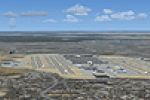
Dakota Smith defines version 1.0 for Hartsfield-Jackson Atlanta International Airport (KATL), Georgia (GA), anchoring the work to the site’s location and using the airport code for identification t…
 United States of America
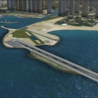
At OMSD, the old track is no longer used and a 2250.00 by 100.10 feet runway takes its place, by Diego Jacobino. AI traffic includes Pilatus PC-6 Porter and de Havilland DHC-6 Twin Otter, totaling …
 United Arab Emirates
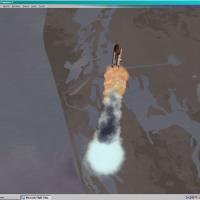
By Ron Jeffers, the effort places you in the Cape Canaveral area to witness a launch or two, with effect attached sounds that accompany each ignition. One or two launches occur in the Cape Canavera…
United States of America
Demonstration work presents a carrier concept for flight simulations, designed for fun to show what can be done, while noting a few issues mentioned by creator Roger Mole (Rollerball). An image fil…
 Global (World)
Pablo Rguez. Glez. authors the project, while CanarySim Xporter is attributed to Francisco Urquia and Luis O. Bethencourt. The release receives express authorization and notes a 2006 origin, clearl…
 Spain
Spain
An upgrade for the default Aerodrom de Saint Jean on Saint Barthélemy (TFFJ) adds parking and taxiways and is modeled after the real-world version. The TFFJ_AIRPORT1.BGL file is used, by Thomas Smi…
 Saint Barthélemy
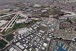
The fourth and final part of my Los Angeles basin series covers Los Alamitos (SLI) and John Wayne (SNA), along with the coast at Huntington Beach, Newport Beach, and Laguna Beach. By Gottfried Raze…
United States of America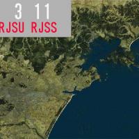
Kenichi Ochiai presents a geographic depiction near Japan’s iconic peak, featuring two image previews that show a ground-level screenshot and an aerial view of Mt. Fuji. The material focuses on a l…
 Japan
Japan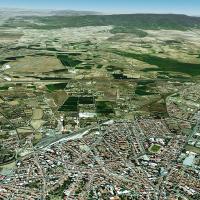
Satellite-derived imagery underpins a complete photoreal coverage of Sardinia and surrounding areas, rendered into a format readable by flight simulators. The compilation is complete and includes a…
 Italy
Italy
Kandahar Ver 1, identified as OAKN, targets Accelerated rendering with DX10/11 support. The package provides 17 parking spaces coded for A-10s and 79 helicopter landing spots, plus a dedicated A-10…
 Afghanistan
By Francesco Mandelli, the adjustment covers the regions for Italy and nearby countries and corrects a long-standing bug. Frame rate is very friendly across these zones, and geographic scope includ…
Italy
Nancy, France, version 2 expands the LFSN project with a full urban area redraw and two new helipads atop city hospitals. The airport hosts 80 custom models and 300 library objects among more than …
 France
Two variants, AGEXCL3X.ZIP and AGEXCL5X.ZIP, remove trees near runways for every airport supplied as standard, clearing 3x or 5x runway width. Both extend 1.5x along the runway length, and two arch…
Global (World)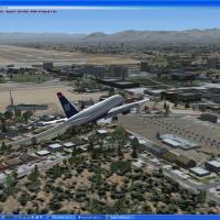
Kambiz Agazi reworks McCarran International (KLAS) by extending Terminal 1’s D gates to reflect Las Vegas operations. Two optional files, KLAS_ApproachLights07R.bgl and KLAS_ApproachLights19R.bgl, …
United States of America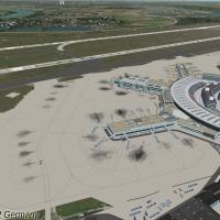
Version 1.0 for the Duesseldorf EDDL area, credited to Max Epperlein and Thomas Ruth, references TOMEDDL1.ZIP and TOMEDDL2.ZIP as identifiers. It corrects the 05L/23R heading, aligns taxiways to an…
 Germany
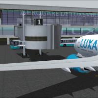
Luxembourg Findel airport entry marks version 1, detailing the addition of new terminal A and B along with the Luxair Cargocenter, while preserving the old terminal and cargo facilities. It centers…
 Luxembourg
CYQB-based Quebec Jean Lesage International Airport, Canada, appears in v3.0 with a Navcanada installation that includes the control tower. It provides lighting on aprons 1 and 2 and installs anten…
 Canada
KMCO identifies the Orlando area airport, with a version 2.0 update that corrects ILS/DME on all ILS runways. Jetways are visible and work, and gates align with current airlines and cargo ramps to …
United States of America
KBOS in Massachusetts receives a total makeover implemented with ADE v1.37, replacing the default layout. Two BGL files, KBOS_ADE_RS.BGL and KBOS_ADE_CW_RS.BGL, present variants with and without cr…
United States of AmericaA set of imagery for autogen buildings is resized from 1024x1024 to 512x512, cutting the size of each file from 683kb to 171kb and reducing loading times to boost FPS. Mip-maps are included and the…
Global (World)