Page 55
Searches the whole library — filter by sim & category on the results page
Harry Patten represents three air bases and airports on Mallorca, adding runway elements and assorted objects across the Balearic island. bgl files carry the layout, reproducing structures and alig…
 Spain
Spain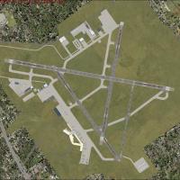
At Islip, New York, the airport add-on replaces the terminal and adds parking, vehicles, and GA hangars, controlled by KISP.bgl, KISP_Lights.bgl, KISP_parklot.bgl, KISP_Ehangers.bgl, KISP_Static_GA…
 United States of America
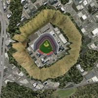
Two landmark fixes by Lance Tucker adjust the Hollywood sign and Dodger Stadium in the Los Angeles area. The fix arrives as LA_cleanup.zip and LAclean.zip, available as freeware and credited to con…
United States of America
At KPAM near Panama City, Florida, this improvement adds Military_Cargo and Military_Combat parking, an expanded apron around the fire station with trucks, plus helipads and a water tower to fill m…
United States of America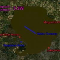
Orlando Seaplane Base addition places a mid-lake runway on Lake Apopka with one mooring dock and a refueling dock offering AVGAS and MOGAS. It uses default objects with no extra downloads, is compa…
United States of AmericaTaoyuan airport in Taiwan receives an ADE-designed modification that relocates the Aviation museum and Novotel while adding assigned parking, extra fuel trucks, and rebuilt roads; three BGL files—R…
 Taiwan, Province of China
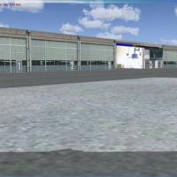
By Alexandre Mugny, this installation advances to version 3, listing four squadrons with aircraft including 17 and 18 on F/A-18 Hornet, 6 on F-5 Tiger, and 1 operating Super Puma, Alouette 3, Couga…
 Switzerland
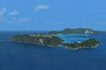
Version 1.00 includes a GMax model of Balls Pyramid and the YLHI airport, with boat traffic around the island. Core components include LHI_CVX.bgl, LHI_DEM.bgl, LHI_Landclass.bgl, LHI_Waterclass.bg…
 Australia
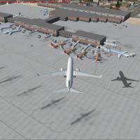
Modifications add jetways and proper parking, while enhancements include static light aircraft, the cargo building, and a fire station along the cargo ramp. Touchups relocate the city layout away f…
United States of America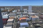
Harutoshi Nakagawa leads a two-year effort to model Japan's northern island, including Sapporo City on Hokkaido, using Gmax. A zip holds a file named sap_effect_fsx, containing a sap_effect folder …
 Japan
Japan
Supported within a Vietnam War project module, USCG Loran C stations are added for Con Son, Sattahip, and Lampang, alongside a C-123 USCG AI aircraft and AI trafic files. It requires VNW_V09.ZIP an…
 Global (World)
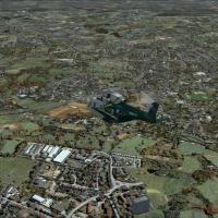
By Aime Leclercq, fall visuals rework cities, villages and culture zones across the globe, with tones darkened and browner and details sharpened by hand. The Fall portion for WWW users furnishes 74…
Global (World)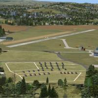
Bembridge EGHJ, Dunkeswell EGTU, and Sywell/Northampton EGBK are repositioned and populated using real-world references. The modification relies on standard data with no custom 3D models beyond lib…
 United Kingdom
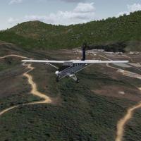
Two BGL files define the Laos airfield layout, with L20A_ADEX_JG.BGL and L20A_ADEX_JG_CVX.bgl, along with Photo_AL18_L20A.BGL and Traffic_L20A_AA.bgl; Xavier Carré is credited. It requires base pac…
 Lao People's Democratic Republic
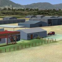
Worcester, a small general aviation airfield near Cape Town in South Africa, sits about 110 km away and serves PPL training and gliding amid surrounding mountains and rivers. Two components, the FA…
 South Africa
Ray Smith leads enhancements for Lihue Airport (PHLI) by offering two runway configurations via PHLI_ADE_RS.BGL and PHLI_ADE_CW_RS.BGL, plus PHLI_ADE_OBJ.BGL containing all objects. The crosswind s…
United States of America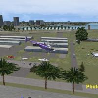
Freeware, officially licensed by AWAPS, presents KSPG at St. Petersburg, Florida, by Jimmy R. Martin and John B. Loney, featuring a new control tower scaled from real plans, a park and taxiway, ter…
United States of America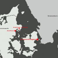
Denmark’s Aarhus Airport EKAH near Tirstrup is presented in v1.0, with the EKAH code and a single variant represented. The distribution includes ekahx10.zip and an Effects directory, while credits …
 Denmark
This 10 m mesh relies on the Sardegna Region GIS terrain models, achieving LOD 12 and spanning the entire Sardinia region in Italy. Version 2 corrects sea water elevations, with attribution to Raim…
 Italy
Italy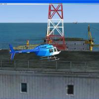
Two offshore oilrigs near Dubai, with accompanying fuel tanks, a refinery, and an onshore HQ building, feature landable helipads on both rigs and the HQ. An archive provides a C_AddonScenery01 fold…
 United Arab Emirates