Page 65
Searches the whole library — filter by sim & category on the results page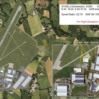
Sywell EGBK-version 2 adds a concrete runway and upgrades buildings for the Sywell airfield in the United Kingdom, credited to Alfred Denham. The Sywell_EGBK_v2 folder integrates with standard host…
 United Kingdom
Ted Kessel delivers modifications across Ohio airfields, including KOSU, KCMH, OH17, 3W2, KLHQ, KSKY, I40 and KMGY, adding expanded parking and removing autogen clutter at sites. Hoover Reservoir b…
 United States of America
NL2000 v4.0 adds a traffic component for the NL2000 v4 framework, delivering general aviation, military, and airline movements. It requires the NL2000 v4 installer and provides Netherlands coverage…
 Netherlands
Lee Marrow expands GABS, Senou International Airport in Mali, adding an expanded terminal complex, revitalized ramps, and reworked parking alignments to improve traffic flow while integrating with …
 Mali
Mali
Hetzleser Berg EDQX, a field sits on a hilltop north of Nuernberg Airport and is surrounded by woods, hosting soaring clubs with aircraft up to 2000 KG MTOW. Glider objects by Wolfgang Piper and a …
 Germany
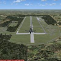
Uwe Steenweg provides two BGL files, ETUR_ADEX_US_V-1.BGL and ETUR_ADEX_US_V-1_CVX.bgl, for Bruggen AB (ETUR) to reflect real taxiways and parking areas. The add-on relies on ADE X 1.50 and include…
Germany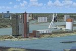
An NL2000 v4.0.20 installer enables a Netherlands-wide 3D update, slots into the NL2000 framework to add windmills, bridges, ships, and city centers, by The Netherlands 2000 Team. From the Scheldt …
Netherlands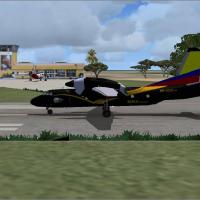
Andres Ramirez creates Leticia Colombia near SKLT, anchoring the work in the Leticia region. Two accompanying screenshots present the area from distinct angles, illustrating the locale and confirmi…
 Colombia
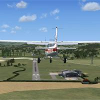
Alf Denham enhances three UK airfields in Volume 11, including Sheffield City Airport EGSY, Sutton Bank XSUT, and Welshpool EGCW. The work blends Google Earth imagery with Pooleys UK Flight Guide a…
United Kingdom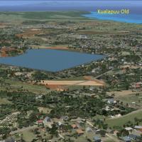
An exhaustive landclass and island modification for Molokai corrects airport layouts PHMK, PHLU, HI49 and adds 18HI, while placing houses and buildings in their true locations across the island. A …
United States of America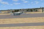
By Ian Jacobson, the regional airport serving Corpus Christi, KCRP gains a layout with five gates, including Gate 2 Southwest and Gate 5 American Eagle, while Gates 1 and 4 remain abandoned. ADE Ve…
United States of America
By Weygantt Kurt, this file adds the missing runway at Koksijde Airbase (EBFN) and arrives as a single bgl that supplements the original airfield. Top-down view differs slightly due to a freeware V…
 Belgium
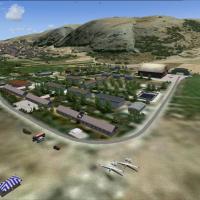
The LTIN Eskisehir Inonu airfield area includes autogen around the main glider operations and surrounding hills, supporting VFR activity. Static models include PZL-104 Wilga (700 polygons) and SZD-…
 Turkey
Alexandre Remy authors version 3 for LFJL in France and makes it freeware for users. The work references an earlier edition such as LFJL2002, with the executable LFJL2007v3.exe and geographic cover…
 France
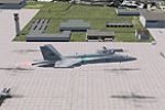
The enhanced KNKX variant at MCAS Miramar in San Diego, by Jim Cook, adds parking spaces, a replaced control tower, a fire station with trucks, static fuel trucks, and revised taxiways and aprons. …
United States of America
Authors Hely Heck Junior - Magrao and Jose Lobo TerraBrasilis assemble a multi-LOD terrain mesh from 90m SRTM2 data, reprocessed with 3DEM to remove voids and spikes, delivering 76.4m horizontal re…
 Cabo Verde
Niue Island area presents 1m/pixel imagery with LOD 15, accompanied by a detailed airport identified as Niue International (NIUE). The work credits Tiberius Kowalski as author, and references the f…
 Niue
Niue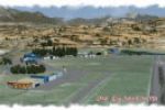
Located in the southeast of France, LFNA Gap Tallard relies on 3D objects built with GMAX1.2 and terrain shaped by SbuilderX; a BGL file named LFNA_ADEX_MO_ALT.BGL supplies airport altitude, while …
France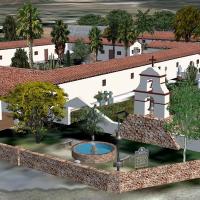
Early California missions installment includes Soledad and San Antonio de Pala Asistencia, CA, with custom built structures derived from satellite imagery for grounds and night lighting, using stan…
United States of America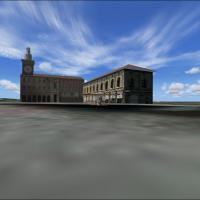
Depiction focuses on a central area of Bologna, highlighting the Cathedral of San Petronio, the Building of Accursio, and the Podesta's building. It extends a prior Bologna project focused on the T…
 Italy
Italy