Page 94
Searches the whole library — filter by sim & category on the results page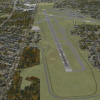
A revision to KERI incorporates the 2012 runway extension at Erie International, linking the new pavement to the existing layout and showcasing a completely rebuilt main terminal. Richard O. Finley…
 United States of America
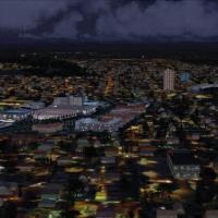
The Bloemfontein project for the virtual landscape presents the South Africa town with custom-designed buildings, freeware, credited to Frits Beyer and Neile Steenkamp, and includes several structu…
 South Africa
The YWDF Delamere range in the Northern Territory spans about half a million acres and sits roughly 80 nautical miles south-southwest of RAAF Tindal. The default airfield is updated to align with i…
 Australia
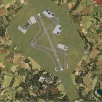
Two locations in the United Kingdom, Culdrose and Predannack, cover EGDR and EGDO, and are developed with ADE 1.22, built from Google Earth imagery, and rely on stock autogen, with creation credite…
 United Kingdom
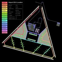
Three alternate configurations accompany a fictional Arctic base in Canada named North Star, in version 7, featuring a triple runway layout and custom library objects. It includes flightplans and A…
 Canada
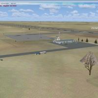
Serving Iran, Sarakhs South (Z14H) appears as version 1, credited to Usof Kalantari, and adds hangars, buildings, and lighting along with increased traffic as part of a photoreal, winter-night pres…
 Iran (Islamic Republic of)
By Andres Ramirez, the Arauca, Colombia airport identified by the ICAO code SKUC becomes the focus. Geographic location in Arauca anchors the project, and the creator receives credit for depicting …
 Colombia
Two image files by Andres Ramirez depict the airfield near Villavicencio, Meta, Colombia known as La Vanguardia, with ICAO code SKVV, and they offer a concise visual reference to the location, high…
Colombia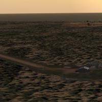
Aeroworx releases a freeware expansion that adds small airfields along the west coast of South Africa for microlight and general aviation pilots seeking authentic low-and-slow adventures. Contribut…
South Africa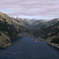
Doug Keech provides Stewart Airport in British Columbia, Canada (CZST) as freeware for flight simulation. It corrects coastlines, rivers, and roads, updates the airport itself, and adds a few objec…
Canada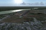
The SVSR airfield sits in San Fernando, Apure State, Venezuela, depicted with photo-terrain from satellite imagery and reflects regional geography. The layout includes a terminal building, control …
 Venezuela (Bolivarian Republic of)
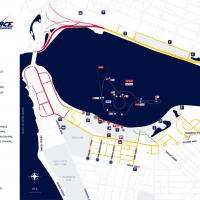
By Siscot Yves, this Red Bull Air Race course traces the Swan River shoreline in Perth, recreating the 2010 layout with pylons and raceways to challenge precision flying. The add-on uses performanc…
Australia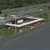
SVLF at La Fria in Venezuela receives an add-on that recreates the terminal building, control tower, and fire station, and adds a heliport, taxiway signs, parking, and vehicles, drawing from a larg…
Venezuela (Bolivarian Republic of)
Costa Rica hosts several airfields scattered around the country, located outside major cities in small towns, along beaches, and amid forested areas. Credits go to Fernando Angel G and Konrad Stain…
 Costa Rica
The inaugural installment in a northern series centers on Hope Airport (5HO) in Alaska. It sits about 20 miles from Stevens Anchorage International, and adds a few static planes at PAMR, all credit…
United States of America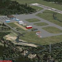
Cranbrook Airport, CYXC, in British Columbia, Canada, appears in a patch by P. Nigel Grant that adapts Vern Opperman’s cyxc04.zip for a format; the cyxc_FSX bundle provides the files and steps to m…
Canada
Raimondo Taburet provides a 5m mesh for the St. Helen area, using a high‑resolution elevation model compiled at 4.8 m. The data exists as bgl files, with an associated image named St_-Helen-5m-Mesh…
United States of AmericaVersion two of the OIMM airport in Iran refines parking, gates, and hangars, with taxiways aligned to real numbers and locations and apronways sorted to improve layout. A single BGL file accompanie…
Iran (Islamic Republic of)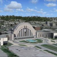
Two objects compose the configuration: the terminal building and a mall, placed at coordinates that align with Ezzard Charles Avenue and the Queensgate yard. The model uses photo imagery from the C…
United States of America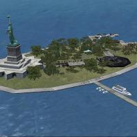
Alan D. Griswold crafts a fictional statue on Liberty Island, delivering a rework of the island in the simulation. Two JPEG images exist, including a primary view and a medium version, and they sig…
United States of America