Page 141
Searches the whole library — filter by sim & category on the results page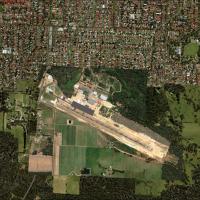
Manjimup, Western Australia, receives an add-on that requires autogen libraries beyond the stock library, including Rwy12, Ez, Orbx, and OzX, and Uwe Schweitzer author credits the file MANJMUP_LT.Z…
 Australia
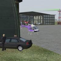
The airfield with code KUWL sits in New Castle, Indiana, and serves as a straightforward add-on for the region, easily identified by its registration. By Jimmy R. Martin, the author emphasizes a si…
 United States of America
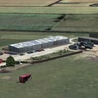
Neil Birch presents a Redlands airfield adjustment for users in Neil’s Microlights North and Midlands areas, and it works with default VFR baselines, though the effect remains invisible there. Two …
 United Kingdom
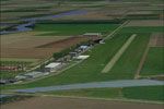
NL2000 v4 ecosystem includes Zeeland Airport (EHMZ) as a modular element for a broader Netherlands-wide layout. The freeware release relies on the NL2000 v4 installer to activate and emphasizes aut…
 Netherlands
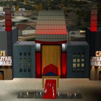
By Andy Johnston, the Los Angeles theater in California centers on its courtyard where stars leave their handprints in cement. This description emphasizes the signature feature and situates the sit…
United States of America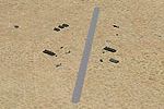
By Aaron Pelon, a compact desert outpost features a short landing strip suitable for small aircraft and helicopters. Two base files, base.bgl and Base.bgl, define the layout and enable use in basic…
United States of America
The Ranger 6000ft Training Camp facility sits east of Port Hardy, BC, and supports resupply training missions with helicopters. A single BGL file named SRTC_ADE_TM Ranger 6000ft BGL covers data, an…
 Canada
Shark Bay at YSHK in Western Australia adds parking and buildings, and the setup requires Rwy12 object libraries, with this work by Frank Salter, tying the location to the Shark Bay region in Austr…
Australia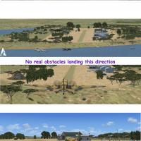
Sunrise Beach is a grass-strip airfield in Central Texas coded 2KL, located in Sunrise Beach Village. Obstacle placement includes 20–30 ft trees along both sides of the runway and trees in the appr…
United States of America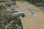
By Cesar Marinho Costa, Teixeira de Freitas airport (SNTF) in Bahia, Brazil gains enhanced fidelity through BGL files, refining the airfield in the city to better reflect its layout and surrounding…
 Brazil
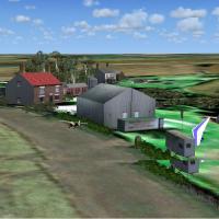
A small grass field aligned 16/34 near Wellingborough in Northants measures 604 m by 23 m and is associated with Neil's Microlights UK, credited to Neil Birch. The accompanying files carry the .bgl…
United Kingdom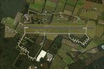
De Peel Air Base, the v4.01 EHDP variant for NL2000 version 4, adds focused coverage within the NL2000 project. The NL2000 v4.0.20 installer completes setup, and The Netherlands 2000 Design receive…
Netherlands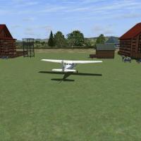
By Saurav Pokhrel, this VNMG add-on for Meghauli Airport in Nepal adapts ADE9X data and Google Earth imagery to place birds, buildings and static aircraft around the airstrip. This add-on includes …
 Nepal
Nepal
Skypark Airport (KBTF) in Bountiful, Utah, gains lighting, vehicles, and people around aircraft, enhancing field realism. Jimmy R. Martin supplies two folders for placement in the addon directory, …
United States of America
Oil City, Pennsylvania hosts a ghost-airfield project centered on Splane Memorial, KOIL (OIL), with two BGL files KOIL_ADEX_ROF.bgl and KOIL_ADEX_ROF_CVX.bgl. The design, by Richard O. Finley, uses…
United States of America
Hybrid of three-dimensional and two-dimensional elements combines Poseidon’s head with a 1930s group of bathers, creating a quirky composite within a single project. MAP.jpg guides navigation throu…
BrazilBlairstown Airport (1N7) in NJ covers 151 acres, is privately owned by J.D. Air Inc., and hosts a mix of small GA planes and gliders, while the addon relies on outdated satellite imagery with missi…
United States of America
An enhancement for a Bolingbrook area airport in Illinois, this project refines 1C5 by placing hand-placed objects such as helipads, hangars, and static aircraft, fuel stations, and vehicles, refle…
United States of America
In Davis, California, University Airport (KEDU, formerly 0O5) receives updated taxiways, runways, and aprons, with relocated buildings and accuracy guided by Google Earth imagery. Airport Design Ed…
United States of America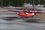
Located east of Talkeetna, Alaska, Grizz's Cabin sits as part of a series that recreates dirt runways to test the skills of virtual bush pilots, by Garrett Smith. Display options list 73 mesh compl…
United States of America