Page 147
Searches the whole library — filter by sim & category on the results page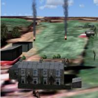
A private airstrip update uses SbuilderX to recreate the surface, enabling 100% coverage. An NDB sits on the field at 200.10, range 6 miles, to aid locating it, and the package includes several bgl…
 United Kingdom
Two folders accompany a field in Elbert County, near Elberton, Georgia, identified by code 27A, with creation credited to Jimmy R. Martin. Screenshots illustrate enhanced terrain and environmental …
 United States of America
Newton airstrip (3N5) lies 3 miles south of Newton, New Jersey, and covers 90 acres as a public field with no transient services or fuel. It relies on satellite imagery for placement and uses ezhou…
United States of America
KFAM in Missouri gains a simple objects addon with lights at the airfield, a concise addition that supports basic ground operations. Jimmy R. Martin is credited as the creator, and the work appears…
United States of America
The Oostwold Airfield module sits within NL2000 v4 modular coverage and places EHOW in Groningen as part of Netherlands-wide layout. It uses high-resolution ground imagery to depict grass and paved…
 Netherlands
At Tappahannock Airport in Virginia (KXSA), Jon Raines presents a project whose terminal mirrors photos available on the airport’s site. The effort remains preliminary, with a final version expecte…
United States of America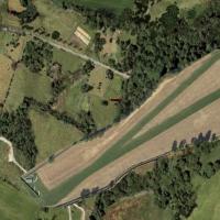
Neil Birch creates a compact midland airstrip experience in the Scottish Borders for microlight pilots, positioned about five nautical miles southeast of Galashiels and seven nautical miles north-n…
United Kingdom
Aaron Bennett crafts a faithful rendition of Alpine Airfield in California, aligning terrain to realistic data and refining the ground layout for accurate short-field operations. The addon introduc…
United States of America
Narrogin Airport (YNRG) sits in Western Australia’s wheat belt, southeast of Perth, as a small rural strip serving local aviation and the Narrogin gliding club. By Frank Salter, it requires Rwy12 o…
 Australia
Expanded Peterhead airport option, by Graham Christie, adds a taxiway fix for AI traffic and introduces a longer four-runway variant. It ships four BGL files in the traffic folder along with two ad…
United Kingdom
By Graham Christie, a fictional airstrip near Peterhead, Scotland, includes two BGL files. It appears on GPS and shows as Peterhead when EGJC is entered, though it does not appear in the airport me…
United Kingdom2N8 Marlboro Airport remains closed since 2002, and the runway is modified to reflect that status while the surrounding area is stripped to reveal satellite imagery, producing a satellite-reference…
United States of America
Riverside Airport (4B2) in New York sits between I-90 and the Erie Canal and features a 3500-foot airstrip. A 10,000-foot water strip defines its amphibious capability, and the layout reflects mid-…
United States of America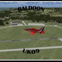
Gordon Barnes recreates Baldoon airfield as UK09 with a single runway to reflect the layout and its wartime history, including target towing operations and the 1942 addition of two concrete runways…
United Kingdom
By Troy Chapman, this self-contained add-on for NZWK at Whakatane replaces previously deleted structures and places a landing pad at NZWK airport only. It includes NZWK_Facilities from the Whakatan…
 New Zealand
Phillip Coyle delivers an ADE-based refinement for Garberville Airport O16, adjusting runway positioning and taxiway widths while expanding parking areas to reflect real-world alignment. Two BGL fi…
United States of America
In Belize, Alf B. Meier presents a Big Creek airstrip add on that serves Savannah and Big Creek communities, with the internal designation MZ63 and an IATA code BGK, coordinates derived from Google…
 Belize
Uwe Schweitzer creates a Manjimup option compatible with MANJIMUP.ZIP, focused on the town of Manjimup in West Australia. Night lighting effects appear, enhancing the local layout while keeping the…
Australia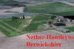
Neil Birch issues NH.ZIP for Nether-Huntleywood in the United Kingdom, designed for Neil's Microlights. It replaces a ground depiction to more accurately reflect the new runway, and requires placin…
United Kingdom
Two files, YOBR_ADE_N and YOBR_ADE_N_OBJ, integrate with Old Bar Heritage Airport, a small airstrip in New South Wales, Australia, under the authorship of Nicholas Cole; Autogen settings require lo…
Australia