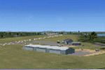
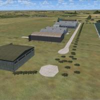
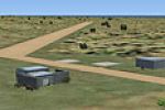
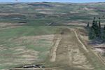
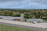
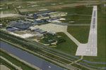
FSX Scenery

Page 131

Preview screenshot

KSC Launch Complex 39

Accurately reconstructing Kennedy Space Center’s Launch Complex 39 for FSX, this scenery add-on realigns the Vertical Assembly Building, replaces five fictional Mobile Launch Platforms with three correctly scaled units, integrates Orbiter Processing Facilities, pad support structures, a wharf-side helipad and geo-referenced photo ground polys, all built solely from default FSX textures to preserve frame-rate neutrality.

Country
United States of America
File Size
282.41 KB
Total Downloads
787
Star Rating
1/5
Screenshots
1
No image available.

El Mirage Field

Hand-built rendition of El Mirage Field (99CL) brings updated apron layout, adjusted elevation data for the dry lake bed, accurate runway markings and subtle photoreal ground textures tailored for Microsoft Flight Simulator X SP1/Acceleration; optimized to blend with MegaSceneryX Southern California and loaded via standard scenery-library workflow by developer Patrick Larson.

Country
United States of America
File Size
14.17 KB
Total Downloads
63
Screenshots
1
Preview screenshot

Charleroi Airport

This FSX-only Charleroi Airport (EBCI) scenery add-on by Alan Mccarthy supplies a .BGL-based upgrade derived from Google Earth data, syncing runway, apron and taxiway geometry with the real Brussels South layout; an accurate Belgian airfield enhancement for Microsoft Flight Simulator X's Addon Scenery directory.

Country
Belgium
File Size
76.44 KB
Total Downloads
893
Star Rating
3/5
Screenshots
1
Preview screenshot

French Alps Altiports

Version 2.0 of the French Alps Altiports scenery for Microsoft Flight Simulator X recreates Courchevel (LFLJ), Megeve (LFHM), Meribel (LFKX) and Alpe d’Huez (LFHU) with sloping, terrain-matched runways, custom elevation data for LOD11 meshes, realistic high-altitude parking, and refined surface textures for challenging alpine bush-flying and short-field operations.

Country
France
File Size
3.71 MB
Total Downloads
2.9K
Star Rating
4/5
Screenshots
4
Preview screenshot

KCRW X Full

Covering FSX Yeager Airport (KCRW), this KCRW X Full v1 scenery injects hand-placed GA hangars, a custom terminal substitute, mapped parking nodes, jetway placements and calibrated ramp lighting derived from Google Earth coordinates, leveraging RWY12 assets and dual FSX Planner AFCAD-style BGLs while sustaining respectable frame rates.

Country
United States of America
File Size
1.87 MB
Total Downloads
411
Star Rating
5/5
Screenshots
3
No image available.

Northam Airport

Frank Salter’s Northam Airport (YNTM) package for FSX brings a re-coded AFCAD from Airport Design Editor, runway profiles aligned via RW12 and FSX-KML, plus data cross-checked against the WA Airstrip Pictorial Guide, giving flyers a precise 41 NM-from-Perth general-aviation strip with correct coordinates, parking stands and surface attributes.

Country
Australia
File Size
2.75 MB
Total Downloads
131
Screenshots
3
Preview screenshot

Cardiff International Airport

Detailed Cardiff International Airport (EGFF) scenery for FSX SP2 adds Gmax-crafted terminals, reflective glass, accurate taxiway layout and integrated photoreal terrain that matches Horizon VFR imagery. Version 1 also flattens mesh cliffs, supplies St Athan RAF Base, VRPs, Porthkerry Viaduct, dynamic road traffic and regional AI schedules while maintaining smooth frame rates.

Country
United Kingdom
File Size
2.73 MB
Total Downloads
2.2K
Star Rating
3/5
Screenshots
2
Preview screenshot

Ku-Kle

Ku-Kle (VNZ5) installs stand-alone BGL scenery files that place a fictional high-altitude Nepalese strip into FSX, purpose-built for STOL practice and risk-laden approaches that make Lukla seem tame; designed for the associated adventure flight, it zeroes in on treacherous dusk operations demanding precise short-field technique.

Country
Nepal
File Size
258.92 KB
Total Downloads
239
Screenshots
3
No image available.

KLAX Fictional Carrier

Placing a custom BGL generated in Flight1’s Instant Scenery, this low-impact enhancement positions a fictional carrier task group just offshore from KLAX, complete with static Blue Angels jets 1-3 parked on the angled deck—ideal for users testing carrier operations, VFR coastal approaches, or naval aviation scenarios.

Country
United States of America
File Size
1.49 KB
Total Downloads
277
Star Rating
5/5
Screenshots
3
Preview screenshot

Seattle-Tacoma International

Focused update for FSX Seattle-Tacoma International Airport (KSEA) revises runway identifiers to current 16C/34C, realigns pavement geometry and taxiway links to FAA charts, fine-tunes ILS glideslope, localizer, DME and PAPI navigation aids, repositions jetways, hold lines and parking while retaining default terminal models, all authored in AFX as freeware scenery.

Country
United States of America
File Size
5.01 MB
Total Downloads
1.4K
Star Rating
5/5
Screenshots
24
Preview screenshot

Lake Grace Airport

Bringing Microsoft Flight Simulator X up to date, this Lake Grace Airport (YLGC) scenery rebuilds the small Western Australia airfield with an ADE-crafted AFCAD, RWY12 static objects and FSX-KML-aligned infrastructure, giving pilots accurate runway headings, corrected elevations and realistically placed hangars, windsock and service facilities.

Country
Australia
File Size
309.57 KB
Total Downloads
55
Screenshots
24
Preview screenshot

Denver Int'l Airport

Patrick Finch’s FSX Denver KDEN overhaul tightens the AFCAD: six crosswind runways enabled, extra jetways keyed to Normal-plus scenery complexity, an enlarged Concourse B with a dedicated United Express commuter pier, refined stand coding, rebuilt ground-service roads separating vehicles from taxiways, added fuel bowsers, and a low-key narrated mission flyover for layout familiarisation.

Country
United States of America
File Size
3.49 MB
Total Downloads
3.7K
Star Rating
5/5
Screenshots
1
Preview screenshot

Thanlwin Bridge Mawlamyine

Thanlwin Bridge Mawlamyine v2.0 adds the full 11,575-ft road-rail span at VYMM to FSX, generated from high-resolution satellite data; the single BGL places scale-accurate dual-lane roadway, four-mile rail track and pedestrian walkways, compiled with FSX Planner/SceneGenX for seamless autogen blending and correct runway-4 sightline, giving Myanmar navigation points proper visual reference.

Country
Myanmar
File Size
17.25 KB
Total Downloads
141
Screenshots
1
Preview screenshot

Lichtenfels Airport

In this FSX SP2-ready enhancement, EDQL Lichtenfels is rebuilt with photoreal ground imagery sourced via SBuilderX and Google World, offering crisp georeferenced textures, accurate runway data and club-field detail for VFR pilots navigating Bavaria’s Franconian countryside roughly 15 NM WNW of Kulmbach; the compact scenery add-on integrates smoothly with DirectX 9 rendering.

Country
Germany
File Size
2.09 MB
Total Downloads
180
Screenshots
2
Preview screenshot

Big Creek Airport

Rendered from ADE and SBuilderX source data, this Microsoft Flight Simulator X scenery enhancement integrates Big Creek Airport (IATA BGK, provisional ICAO MZ63) near Savannah, Belize, delivering precise runway geometry, apron layout, terrain alignment and threshold structures, yielding regional carrier traffic flows while retaining the strip’s forgiving approach profile beyond a handful of buildings.

Country
Belize
File Size
112.89 KB
Total Downloads
66
Screenshots
1
Preview screenshot

Berkeley Marina

Augments FSX’s default San Francisco Bay with a fully populated Berkeley Marina: static and AI boats, articulated docks, dedicated seaplane slips, a functional fuel berth, and ambient bird formations tied to Autogen density. The BGL integrates seamlessly with Living World algorithms, delivering realistic maritime traffic without notable FPS penalties.

Country
United States of America
File Size
1.83 MB
Total Downloads
196
Screenshots
16
Preview screenshot

Caye Caulkner Airstrip

FSX Caye Caulkner Airstrip scenery adds a custom bush strip to Microsoft Flight Simulator X, placing the 800-yard, 10-yard runway (unofficial MZ59, IATA CUK) accurately on the Belize cay with Google Earth coordinates, SBuilderX data and an ADE-tuned AFCAD that depicts the west-end precipice and eastern rough, suiting short-field STOL island hops.

Country
Belize
File Size
128.63 KB
Total Downloads
51
Screenshots
1
Preview screenshot

El Ranchito Airport

Custom FSX enhancement installs El Ranchito’s 600-yard x 12-yard grass strip (unofficial ICAO MZ60, IATA CZH) near Corozal, Belize, using precise Google-Earth geodata plus SBuilderX and ADE vector work; hand-tuned vegetation exclusion and brush collision logic make it a solid spot for bush flying, short-field drills, and regional VFR operations.

Country
Belize
File Size
97 KB
Total Downloads
45
Screenshots
1
Preview screenshot

Punta Gorda Airport

Compact Belizean airstrip enhancement for Microsoft Flight Simulator X replicates Punta Gorda (PND/MZ62) with its gravel runway, basic twin-hut terminal and obstacle-critical approach profile. Compiled in BGL via SBuilderX and Airport Design Editor, it supplies corrected coordinates and realistic terrain integration, suiting bush flying, GA ops and regional airline schedules.

Country
Belize
File Size
181.82 KB
Total Downloads
100
Screenshots
1
Preview screenshot

Sarteneja Airport

This FSX scenery add-on renders Belize’s Sarteneja bush airfield (IATA SJX, custom MZ61) using geo-referenced Google Earth data; compact BGLs compiled with SBuilderX and Airport Design Editor deliver an accurate runway footprint for VFR bush flying toward Shipstern Wildlife Reserve and the daily Tropic Air commuter service.

Country
Belize
File Size
90.62 KB
Total Downloads
55
Screenshots
1