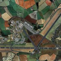
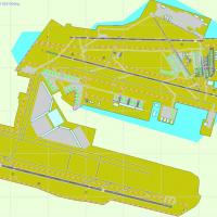
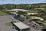
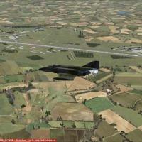
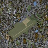
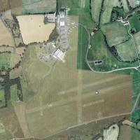
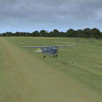
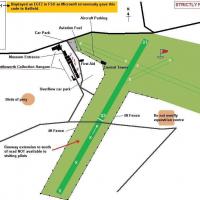
FSX Scenery

Page 34

Sort
Reset
Preview screenshot

Saul French Guyana

Dominique M. L. Donzelot presents the SOOS airstrip in the Guyana jungle, about 110 miles south of Cayenne, where terrain restricts operations and landing on 21 is prohibited when 03 is unavailable for takeoff. Not compatible with earlier versions, the work relies on existing elements and suits bush-pilot use with twin-engine cargo aircraft.

Country
French Guiana
File Size
491.09 KB
Total Downloads
297
Star Rating
1/5
Screenshots
4
Preview screenshot

KBTR Beta

KBTR Beta v1.0 for Baton Rouge, Louisiana, brings city buildings and river traffic from KBTRv2 into the scene. By Joe DeGregorio, it highlights the Tall State Capitol Building, Cortana Mall, and Exxon, and all required files are included.

Country
United States of America
File Size
21.19 MB
Total Downloads
296
Screenshots
2
Preview screenshot

NL2000 V4.03 Volkel Air Base

The NL2000 v4.03 edition covering Volkel airfield, designed by The Netherlands 2000 Design Team, depicts accurate runways and taxiways aligned to real coordinates, plus hardened shelters and support buildings. NL2000 v4.0.32 installer is required, and photoreal ground imagery covers North Brabant, preserving landmarks and regional details, with night lighting on runways and aprons.

Country
Netherlands
File Size
65.48 MB
Total Downloads
288
Preview screenshot

Hergest Ridge

A photoreal landscape traces the England–Wales border between Kington in Herefordshire and Gladestry in Powys, with a highest point at 1397 feet. It aligns with UTX Europe and preserves a photoreal representation across terrain, by Pips Perez.

Country
United Kingdom
File Size
42.67 MB
Total Downloads
288
Star Rating
1/5
Screenshots
1
Preview screenshot

South African Game Lodges

By Wessel Bonnet, six real-world game lodge airstrips are faithfully recreated from charts within the Hoedspruit–Skukuza–Sabie corridor, using ADE, with visible animals, lodges and routes. Trees and shrubs cover parts of some runways, and the files use the .bgl format.

Country
South Africa
File Size
760.1 KB
Total Downloads
285
Preview screenshot

Scotland Stirling International

By design, the field presents two parallel runways, RWY 06L/24R at 3200 by 50 meters and RWY 06R/24L at 2440 by 50 meters, each with displaced thresholds and respective landing distances of 2895 and 2135 meters. An on-field VOR/DME supports navigation, and all approaches feature ILS.

Country
United Kingdom
File Size
1.09 MB
Total Downloads
274
Star Rating
4/5
Preview screenshot

Kingscote Airport

An early version (version 1) by Roger Leupold presents an airport rendition featuring custom objects arranged to mirror taxiways, ramps, and lighting, with runways aligned using Google Earth imagery. The version targets a single variant and remains faithful to the surrounding landscape, with certain hangars being simplified for performance.

Country
Australia
File Size
1.36 MB
Total Downloads
269
Star Rating
1/5
Screenshots
1
No image available.

Aeropuerto Almirante Padilla

By Anwar Gonzalez, the public airport near Riohacha, Colombia, carries the designation SKRH with IATA RCH and ICAO SKRH, operated by Aerocivil. It sits at 13 m elevation (43 ft) and at coordinates 11°31'34" N, 72°55'33" W, featuring a 1,760 m asphalt runway labeled 10/26 and supporting Avianca and Líneas Aéreas Suramericanas operations.

Country
Colombia
File Size
6.46 KB
Total Downloads
269
Preview screenshot

Gullknapp

Marius Risan releases Gullknapp ENGK, a small-airport installation for a rural field near Arendal, Norway, identified by the ENKG code. The author distributes it as freeware and ties the ENKG tag to the local location along the Norwegian coast.

Country
Norway
File Size
1.85 MB
Total Downloads
268
Screenshots
1
Preview screenshot

VEPT Patna

VEPT Patna in India receives minor airfield improvements with hand-placed touchdown zones via the Lance Tucker library, featuring 500 ft bars and 1000 ft TDZ marks at each end, and PAPI relocated on both runways. It is designed for a base representation and relies on the rwy_mark.zip file for full TDZ realism.

Country
India
File Size
248.14 KB
Total Downloads
264
No image available.

Mont-Tremblant Int'l

La Macaza in the Laurentides, Quebec, Canada, hosts Mont-Tremblant International Airport (CYFJ) and gains an ADE file that enhances realism for a city-led project for this facility. This change aligns with the city of Mont-Tremblant's project for the international facility.

Country
Canada
File Size
5.51 KB
Total Downloads
264
Preview screenshot

Groton New London Airport

KGON in Connecticut gains GA parking, two fuel trucks, and a RI National Guard area with static aircraft. Taxiways and signage undergo reconfiguration. Two BGL files support the changes, by Kyle Cormier for simulation use.

Country
United States of America
File Size
9.7 KB
Total Downloads
260
Preview screenshot

Pease AFB

Steve Hess changes the parking configuration at Pease International Tradeport (KPSM) in New Hampshire to mirror Pease AFB days, restoring a layout associated with the former base. The description notes the site in the region with the Pease heritage and its airport designation.

Country
United States of America
File Size
1.14 MB
Total Downloads
258
Preview screenshot

Scenery Fix For FVHA Harare Airport

Lee Marrow provides a fix for Harare International Airport, revising the FVHA1.ZIP file to restore missing buildings that were excluded by error. Within Zimbabwe, the adjustment corrects an inadvertent omission that left terminal and apron buildings absent in the prior configuration, and the revision is attributed to Lee Marrow.

Country
Zimbabwe
File Size
11.93 KB
Total Downloads
248
Preview screenshot

Kittyhawk Aero Estate

Private aerodromes east of Pretoria include Zyn Kraal and Rhino Park beside Kittyhawk estate. Kittyhawk receives an updated ground layout with taxiways and hangers, while Zyn Kraal has no ICAO ID yet, and Rhino Park lacks ICAO ID or runway markings, its main runway tarred on 27/09.

Country
South Africa
File Size
204.02 KB
Total Downloads
246
Star Rating
1/5
Screenshots
1
Preview screenshot

BollingAFB/Anacostia NAS

This Washington-area add-on revisits Bolling AFB and Anacostia NAS after fixed-wing traffic ends in 1962 as Navy and Air Force operations shift to Andrews AFB. A file named AFX_KBOF_ALT.bgl is described as a Flatten file, and credits go to John Hawranick, Jr.

Country
United States of America
File Size
438.66 KB
Total Downloads
246
Screenshots
1
No image available.

V2 Johannesburg Power Stations

By Frits Beyer, a V2.0 edition covers South Africa’s power facilities and adds a custom building at Orlando powerstation, while the initial version is removed in favor of this configuration. The change highlights the Orlando addition and the replacement of the first instance with the updated layout.

Country
South Africa
File Size
295.34 KB
Total Downloads
246
Preview screenshot

Aurora Municipal Airport

Aurora city airport, designated KARR, serves Chicago area and Kane County, with a paved main runway measuring 6500 feet at 706 feet elevation, located about 38 miles from Chicago. Greater Kankakee Airport (KIKK) lies 3 miles from Kankakee, offers a 5979-foot paved runway at 629 feet, and is owned by the Kankakee Valley Airport Authority.

Country
United States of America
File Size
1.11 MB
Total Downloads
244
Screenshots
14
Preview screenshot

Vieques Culebra

Roberto Ayala provides original terminal buildings for Vieques (TJVQ), Fajardo (TJFA), and Culebra (CPX) on Puerto Rico, reflecting the island's eastern air routes. Eastern Puerto Rico includes Vieques, Fajardo, and Culebra, with airport codes acknowledged.

Country
Puerto Rico
File Size
745.66 KB
Total Downloads
244
Star Rating
3/5
Screenshots
3
Preview screenshot

Guaxupe Airport

Cesar Marinho Costa presents an enhancement for SNGX in Guaxupe, Minas Gerais, Brazil, adding details to Guaxupe Airport and including communications such as Broadcast Guaranesia (GUA) on 1580 and tower on 123.45. The offering is free and cannot be sold.

Country
Brazil
File Size
12.85 KB
Total Downloads
244
Star Rating
1/5