Canada

Page 6

Sort
Reset
Preview screenshot

Battures de Beauport

Handling the industrial shoreline of Battures de Beauport, this FSX scenery add-on lays photoreal ground textures with day/night and winter variants across Quebec City’s eastern port in Canada, inserting bulk terminals, coal stacks, ore conveyors, cranes, storage tanks and moored cargo vessels; well suited for VFR freight runs along the St. Lawrence and fully compatible with the default mesh.

File Size
7.36 MB
Total Downloads
272
Screenshots
2
Preview screenshot

Jack Garland Airport

FSX rendition of Canada’s CYYB Jack Garland Airport refreshes the stock layout, re-aligning AFCAD data, activating runway 13/31 as a grass and water strip, adding a three-bay floatplane marina, helipads for training ops, extra GA parking, and accurate AI routes beside the 10 000-ft primary runway.

File Size
404.12 KB
Total Downloads
271
Screenshots
2
Preview screenshot

Quebec Shorelines

Covering the Québec–Baie-James hydro scheme zone, this FSX water upgrade redraws coastlines, lakes and river polygons with precise BGL vector data, aligning with 38 m LOD10 mesh for accurate elevation and stable shore gradients; useful for VFR legs across Canada’s boreal north and St-Lawrence tributaries.

File Size
63.23 MB
Total Downloads
271
Screenshots
5
No image available.

Mont-Tremblant Int'l

CYFJ Mont-Tremblant International scenery refresh for Microsoft Flight Simulator X brings the Laurentides airfield into current specs: revised ADE layout, corrected runway 02/20 geometry, re-charted taxi links, realistic ramp allocation, signage and lighting matching municipal redevelopment plans, supporting general aviation and seasonal charter traffic across Quebec.

File Size
5.51 KB
Total Downloads
264
Preview screenshot

Ganges Harbour

Microsoft Flight Simulator X pilots charting Canada can add modest realism to British Columbia’s Saltspring Island with this Ganges Harbour package, refreshing shorelines, landclass and road vectors while introducing accurate AfCad starts for CAX6 seaplane operations and CAL7’s hospital helipad—all achieved solely with stock objects, preserving performance and freeware convenience.

File Size
443.48 KB
Total Downloads
264
Screenshots
3
Preview screenshot

Birds Volume 7: The Gold Valley

Avian traffic comes to Canada’s rugged Bella Coola corridor with FSX “Birds Volume 7: The Gold Valley,” adding animated flocks, custom bird calls and seasonal AI behaviors to British Columbia’s forested slopes and river flats. The lightweight scenery layer enriches VFR bush flying and amphibious operations without altering default mesh or photoreal coverage.

File Size
1018.76 KB
Total Downloads
252
Screenshots
9
Preview screenshot

CFB North Star V5

CFB North Star V5 plants a fictional CYNS hub in Canada’s high Arctic, bringing four scenery variants, updated landclass, seasonal AI flight plans, LOD-efficient geometry, refined ramp markings, a compact weapons range, plus CCGS Louis St-Laurent icebreaker traffic, compiled for Microsoft Flight Simulator X SP2-level platforms.

File Size
28.76 MB
Total Downloads
250
Screenshots
10
No image available.

CYQQ CFB Comox Update

FSX CYQQ CFB Comox Update scenery enhances Canada’s 19 Wing air base on Vancouver Island, correcting the runway 12 ILS localizer alignment, fine-tuning glide-slope navdata, adding extra apron parking positions, and removing tree obstructions from the approach lighting array for more precise military and civil simulator traffic.

File Size
27.25 KB
Total Downloads
245
Star Rating
2/5
No image available.

Revelstoke Airport

CYRV Revelstoke Airport in British Columbia, Canada—this Flight Simulator X scenery update corrects the pre-2006 heading data, sets runway 12/30 at 138° true, introduces medium edge lighting and accurate runway markings, refreshed aprons, AFCAD-based GA parking and relocated helipad; the package adds background polygons and autogen exclusions tuned for VFR operations in the Columbia River canyon terrain.

File Size
6.39 KB
Total Downloads
241
Preview screenshot

Gaspesie

This Canada scenery plug-in for Microsoft Flight Simulator X (FSX) replicates Quebec’s Gaspé Peninsula with animated wind-power sites, detailed Percé Rock, Cap Gaspé lighthouse, and Mont Castor and Mont Béchervaise ski slopes, geo-referenced for reliable VFR circuits along Route 132 and the Appalachian-linked Chic-Choc range.

File Size
4.08 MB
Total Downloads
241
Screenshots
9
Preview screenshot

Qualicum Beach Airport

CAT4 Qualicum Beach Airport scenery for Microsoft Flight Simulator X recreates this Vancouver Island BC coastal strip with custom landclass, updated forest-to-logging transitions, accurate runway and taxiway layout via ADE, FSDS-built structures, static and AI general-aviation traffic, and region-specific autogen—an unobtrusive freeware upgrade for low-level VFR touring across western Canada.

File Size
3.86 MB
Total Downloads
240
Screenshots
6
Preview screenshot

Lillooet Airport

Fraser Canyon’s rugged rim now sits under upgraded FSX autogen with this freeware depiction of Lillooet Airport (CAR3), bringing corrected runway thresholds, custom structures, tweaked landclass and optimized draw calls for smooth frame-rates; ideal for bush pilots running short-haul GA ops across western Canada or practicing challenging VFR approaches.

File Size
2.17 MB
Total Downloads
239
Star Rating
1/5
Preview screenshot

Abbotsford International

FSX and Microsoft Flight Simulator X users planning domestic or trans-border sorties into British Columbia will find Abbotsford International CYXX in this scenery add-on quietly re-engineered with ADE; both runways stretched to 5,328 and 9,600 ft, thresholds aligned, crosswind logic active, updated VASI, corrected aprons, roads and hangars, plus static aircraft, low-impact night lighting and functional jetways.

File Size
715.44 KB
Total Downloads
237
Screenshots
2
Preview screenshot

CYRC - Chicoutimi Airport

Canadian flyer package for CYRC Chicoutimi Airport drops a refined FSX / P3D scenery, adding the delta-pattern three-runway layout, functional NDB procedure, corrected apron geometry, parking stands, custom buildings, seasonal wildlife cues and bundled charts—ideal for VFR hops across Quebec or cross-country IFR planning.

File Size
4.98 MB
Total Downloads
235
Screenshots
4
Preview screenshot

Bathurst Airport

Covering Bathurst Airport CZBF in northern New Brunswick, this FSX scenery plug-in refreshes the 5,772-ft asphalt strip, updated taxiway layout, small GA apron with three stands, photoreal ground polys and shoreline detail; useful for VFR hops toward Îles-de-la-Madeleine, floatplane detours to adjacent lakes, or regional twin-engine circuits, complete with Canadian AIP charts.

File Size
1.85 MB
Total Downloads
217
Screenshots
4
Preview screenshot

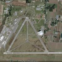
V2 Boundary Bay Airport

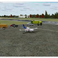
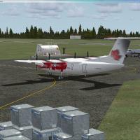
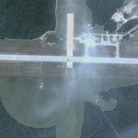
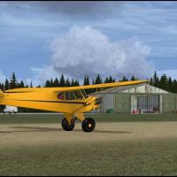
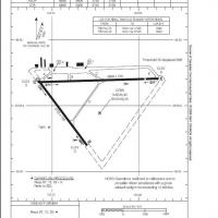
Updated FSX rendition of Canada’s CZBB Boundary Bay Airport brings a repositioned control tower, extended 07/25 runway to 5,606 ft, added taxiway E, accurate VASI, crosswind support, revised aprons, detailed signage, fueling truck logic, static vegetation and objects, aligning with 2008 charts and Google Earth data. Tailored for Microsoft Flight Simulator X, the scenery supports Vancouver-area GA flying and IFR drills.

File Size
138.02 KB
Total Downloads
214
Screenshots
2
Preview screenshot

Naval Air Station Argentia

Focusing on the former U.S. Naval Air Station Argentia (CWAR) in Newfoundland, this Microsoft Flight Simulator X scenery add-on rebuilds the twin-runway field, adjacent docks and Cold War support blocks circa 1994, supplying updated AFCAD, landclass tweaks and static detail for realistic naval aviation, maritime patrol and training sorties.

File Size
2.9 MB
Total Downloads
209
Screenshots
7
Preview screenshot

Gouin Dam - Barrage Gouin

Covering Gouin Dam (CTP3) and the adjacent reservoir north of La Tuque, this FSX scenery add-on renders the hydroelectric structure, connected docks, sand strips, private chalets, Hydro-Québec facilities and Smurfit-Stone plant, replicating the complex shoreline and bush flying terrain around Barrage Gouin, at the source of the Saint-Maurice River, plus supplementary strip CB31 for floatplane and tundra-tyre operations.

File Size
5.84 MB
Total Downloads
206
Screenshots
19
Preview screenshot

Tipella Lookout Station

Tipella Lookout Station introduces a high-elevation STOL backcountry strip above Harrison Lake in British Columbia, offering a grass, uphill runway at 4,844 ft, custom Unicom 124.325, an unmarked helicopter spot and detailed terrain mesh; suited to VFR bush pilots refining short-field technique in FSX amid rugged Canadian mountains.

File Size
1.03 MB
Total Downloads
203
Screenshots
5
Preview screenshot

CWY9 - Your Own Airport

Positioned on a secluded British Columbia cove, CWY9 introduces a private field to Microsoft Flight Simulator X with an 8,500-ft reinforced concrete strip (125-ft width), type-5566Xc taxiways, full dusk-to-dawn edge lighting, illuminated aprons, custom AFCAD, small coastal town scenery, twin marinas, busy AI road traffic and nearby carrier group.

File Size
4.7 MB
Total Downloads
198
Screenshots
10

9 pages with 161 downloads.

previous123456789next