Canada

Page 7

Sort
Reset
Preview screenshot

Fort Smith Airport

Covering Fort Smith Airport (CYSM/YSM) in Canada’s Northwest Territories, this FSX add-on scenery, built with ADEX, refreshes runway geometry, gravel strip 02/20, apron markings and night lighting, swaps the stock terminal for a custom object-library build, inserts access roads, static vehicles and GA parking, and bundles IFR/VFR approach plates for accurate virtual circuit work.

File Size
4.51 MB
Total Downloads
209
Star Rating
2/5
Screenshots
3
Preview screenshot

Naval Air Station Argentia

Focusing on the former U.S. Naval Air Station Argentia (CWAR) in Newfoundland, this Microsoft Flight Simulator X scenery add-on rebuilds the twin-runway field, adjacent docks and Cold War support blocks circa 1994, supplying updated AFCAD, landclass tweaks and static detail for realistic naval aviation, maritime patrol and training sorties.

File Size
2.9 MB
Total Downloads
206
Screenshots
7
Preview screenshot

Lewisporte, Newfoundland

Lewisporte CYLE introduces a compact turf strip and sheltered waterway near Newfoundland’s Gander Bay, replacing default shorelines and adding previously missing lakes to Microsoft Flight Simulator X. Tailored for STOL and float aircraft—such as the A2A Piper Cub with Accu-Sim—this freeware download updates Canadian landclass, aids VFR bush flying, and integrates seamlessly with default libraries.

File Size
1.46 MB
Total Downloads
206
Star Rating
5/5
Screenshots
7
Preview screenshot

Tipella Lookout Station

Tipella Lookout Station introduces a high-elevation STOL backcountry strip above Harrison Lake in British Columbia, offering a grass, uphill runway at 4,844 ft, custom Unicom 124.325, an unmarked helicopter spot and detailed terrain mesh; suited to VFR bush pilots refining short-field technique in FSX amid rugged Canadian mountains.

File Size
1.03 MB
Total Downloads
202
Screenshots
5
Preview screenshot

Gouin Dam - Barrage Gouin

Covering Gouin Dam (CTP3) and the adjacent reservoir north of La Tuque, this FSX scenery add-on renders the hydroelectric structure, connected docks, sand strips, private chalets, Hydro-Québec facilities and Smurfit-Stone plant, replicating the complex shoreline and bush flying terrain around Barrage Gouin, at the source of the Saint-Maurice River, plus supplementary strip CB31 for floatplane and tundra-tyre operations.

File Size
5.84 MB
Total Downloads
202
Screenshots
19
Preview screenshot

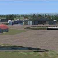
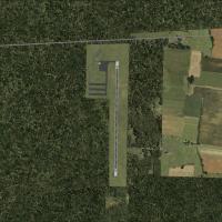
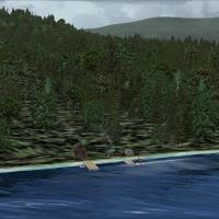
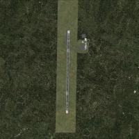
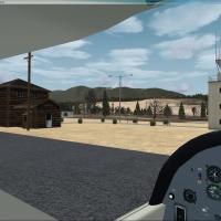
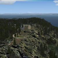
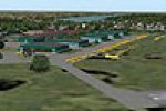
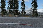
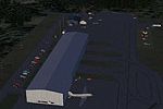
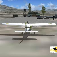
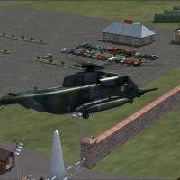
CWY9 - Your Own Airport

Positioned on a secluded British Columbia cove, CWY9 introduces a private field to Microsoft Flight Simulator X with an 8,500-ft reinforced concrete strip (125-ft width), type-5566Xc taxiways, full dusk-to-dawn edge lighting, illuminated aprons, custom AFCAD, small coastal town scenery, twin marinas, busy AI road traffic and nearby carrier group.

File Size
4.7 MB
Total Downloads
194
Screenshots
10
Preview screenshot

Scenery For Collingwood

Collingwood CNY3 for Microsoft Flight Simulator X lays out this Ontario aerodrome with default and EZ-Library assets, matching apron geometry, hangar placement and nearby terrain. Compatible with Ultimate Terrain X Canada, the freeware package supports VFR views of Blue Mountain, Scenic Caves and Wasaga Beach, and the 5,000 ft strip readily accommodates CRJ-size traffic.

File Size
173.45 KB
Total Downloads
192
Star Rating
1/5
Screenshots
1
Preview screenshot

Owen Sound Airport

The CYOS Owen Sound Billy Bishop Regional Airport package for Microsoft Flight Simulator X refreshes this Georgian Bay aerodrome with photoreal ground polys, custom hangars, accurate apron markings, updated Navaids and taxiway designators created in ADE, producing a credible Canadian GA stopover for bush flying, training and charter flights.

File Size
5.8 MB
Total Downloads
190
Star Rating
4/5
Screenshots
20
Preview screenshot

Cozy Cabin

Cozy Cabin situates a modest timber hideaway near Salt Spring Island, British Columbia, giving FSX bush pilots and amphibious flyers a fresh Gulf Islands waypoint that relies solely on default scenery assets—handy for short STOL hops, floatplane supply runs, or relaxed GA circuit practice.

File Size
5.87 MB
Total Downloads
190
Star Rating
4/5
Screenshots
22
Preview screenshot

Fireworks Of St. Jean

This Flight Simulator X add-on places realistic, GPU-efficient pyrotechnics over Île Sainte-Hélène, Montreal and Montmorency Falls, Quebec, triggering at 21:00 on 24 June to mark St-Jean-Baptiste Day; custom BGL scenery calls particle emitters and dynamic night lighting, enriching VFR hops across Canada’s festive summer skyline.

File Size
33.5 KB
Total Downloads
190
Screenshots
1
No image available.

CYYG Charlottetown Update

FSX CYYG Charlottetown Update refines Prince Edward Island’s primary airport with a corrected AFCAD, installing full approach lighting and VASI on runway 03, clearing obstacle vegetation on both 03/21 thresholds, and supplying updated BGL files for accurate glideslope cues in Microsoft Flight Simulator X regional scenery libraries.

File Size
18.24 KB
Total Downloads
187
Preview screenshot

AFX File For CYHZ

Halifax Stanfield International (CYHZ) gains an up-to-date AFCAD via this AFX BGL, bringing realigned taxiway geometry, corrected parking stand coordinates, stand labelling for regional, domestic and international traffic, full dual-runway AI flow, and refined edge, threshold and approach lighting tailored to the FSX default terrain.

File Size
64.52 KB
Total Downloads
186
Screenshots
1
Preview screenshot

Aeroport de Havre St-Pierre

CYGV – Aéroport de Havre-Saint-Pierre for FSX is a scenery add-on revitalising the remote Québec Côte-Nord airfield through Gmax-crafted terminal, hangars, fuel points, signage, fenced perimeters, helo pads R01/R02 and corrected AFCAD, aligning navaids for regional turboprops, bush flying and AI traffic patterns along the Gulf of St. Lawrence.

File Size
6.44 MB
Total Downloads
179
Star Rating
5/5
Screenshots
22
No image available.

AFX File For CYOW

Designed for the Canada index, this CYOW Ottawa/Macdonald-Cartier AFX data pack injects GPS-compatible RNAV STARs and approaches—RIVER FOUR, MEECH FOUR, DEANS TWO, CAPITAL SIX—into FSX, furnishing current IFR waypoint sequencing, altitude constraints and runway alignment for 07/14/25/32 to support precise autopilot-guided arrivals.

File Size
10.38 KB
Total Downloads
177
Preview screenshot

Fairmont Hot Springs

Covering CYCZ Fairmont Hot Springs in British Columbia’s Columbia Valley, this Microsoft Flight Simulator X add-on layers a 6,000-ft asphalt runway, revised AFCAD data, custom-built terminal, ATC tower, ample GA and charter stands, realistic approach lighting, and terrain-matched elevation tweaks, offering a mountain airfield option for VFR and IFR practice in the Canadian Rockies.

File Size
775.04 KB
Total Downloads
175
Screenshots
3
Preview screenshot

Gulf Island Research

Situated 13 nm northeast of Victoria International, Gulf Island Research (ICAO: GIR) adds a fictive Pacific Northwest research outpost with a 600-ft dirt STOL strip, twin helipads and abrupt terrain drops—useful for bush flying practice, rotary-wing shuttle work and low-level navigation in Microsoft Flight Simulator X.

File Size
441.13 KB
Total Downloads
174
Screenshots
3
Preview screenshot

Baie James Hydroelectric Complex

Covering N52–N56, W66–W80, this FSX terrain mesh renders the Baie-James Hydroelectric Complex in northern Quebec at 38 m LOD10 resolution, sharpening rivers, reservoirs and tundra contours for precise VFR bush hops or IFR transitions across Canada’s vast sub-arctic plateau.

File Size
106.62 MB
Total Downloads
165
Star Rating
5/5
Screenshots
26
Preview screenshot

BCATP Total Stations To Date

Spanning nearly 160 historic British Commonwealth Air Training Plan stations scattered across Canada, this FSX add-on positions each turf or hard-surface strip to line up with Ultimate Terrain roads and Flight Ontario landclass, supplying Microsoft Flight Simulator X users with period-correct 1940s training aerodromes ideal for VFR circuits, navigation exercises and heritage bush flying.

File Size
46.43 MB
Total Downloads
163
Star Rating
5/5
Preview screenshot

Mule Creek

Quiet bush flying north of the Cassiar Highway comes alive with this FSX rendition of Mule Creek (CBS4), British Columbia, adding the ranger station, service cabins and terrain tweaks that aid VFR navigation; lightweight BGL design keeps frame-rates steady, making it a handy freeware hub for GA and rotary-wing pilots.

File Size
140.35 KB
Total Downloads
156
Screenshots
1
Preview screenshot

Fictional Airbase In Canada

Set within a steep-sided Canadian valley, this fictional FSX (Microsoft Flight Simulator X) airbase blends default structures with freeware assets, providing dual hard-surface runways—fighter launch strip plus Runway 11 cargo departure—enhanced flood- and overhead-lighting for night ops, animated ramp activity, refueling bay, and surrounding mountainous terrain that demands careful departure planning.

File Size
9.5 MB
Total Downloads
155
Screenshots
1

9 pages with 161 downloads.

previous123456789next