United Kingdom

Page 13

Sort
Reset
No image available.

EGNX

East Midlands Airport (EGNX) AFCAD refresh aligns FSX and P3D ground layouts with current AIP data, adding the passenger apron extension—stands 40-45—and correct stand labeling, revised taxiway links, a taller control tower object, fire station placement and the removal of obsolete jetways for accurate AI traffic behavior.

File Size
8.89 KB
Total Downloads
249
No image available.

Cardiff Update

This focused FSX patch for Cardiff Airport EGFF swaps in a revised egfftank.bgl, deletes egfffence.bgl and introduces updated fuelshed textures, removing CTDs around the fuel farm; sim flyers can taxi, park and refuel without collision-box errors, giving this Welsh hub steadier performance and visual consistency.

File Size
3.27 MB
Total Downloads
245
No image available.

Plymouth GPS Enabled Carrier

In this FSX United Kingdom scenery add-on, a GPS-enabled static carrier (ICAO EG51) is moored in Plymouth Sound, giving pilots a reliable spawn point for the EH101 or any aircraft, deck-aligned catapult trials, and direct world-wide slew access—ideal for practicing short-field naval approaches, carrier circuits and helicopter ferry legs within Microsoft Flight Simulator X.

File Size
5.93 KB
Total Downloads
243
Preview screenshot

Blackbushe UK Expansion

This Blackbushe UK Expansion scenery for Microsoft Flight Simulator X reimagines EGLK with a 6,500-ft 08/26 strip, dual-end ILS, south-side full-length taxiway, enlarged apron and new terminal capable of handling regional jets, while the original secondary runways are decommissioned and marked out, giving GA pilots and virtual ATC believable traffic patterns.

File Size
841.66 KB
Total Downloads
235
Screenshots
2
Preview screenshot

Perth/Scone

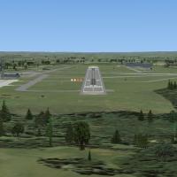
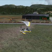
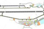
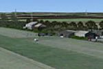
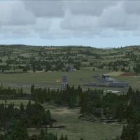
Covering EGPT Perth/Scone in central Scotland, this FSX scenery add-on extends runway 03/21 to 4,500 ft with 1,500 ft TDZ markings, adds a modest terminal at the 03 threshold, supplies executive stands for BAe 146-class traffic, re-profiles GA aprons, and seeds the field with static aircraft, vegetation and other objects for a more credible UK regional airfield environment.

File Size
4.22 MB
Total Downloads
234
Star Rating
5/5
Screenshots
20
No image available.

Generation X Airfields

Targeted at Microsoft Flight Simulator X users running Horizon Generation X photoscenery, this enhancement installs 18 small UK airfields—Chedder, London Colne, Rush Green and others—bringing revised elevations, aligned runway thresholds, custom ground polys and realistic tree lines, useful for low-level VFR navigation, GA training or bush-style sorties.

File Size
55.17 KB
Total Downloads
230
Preview screenshot

Unst Airport

Covering Britain’s northernmost strip, this FSX add-on places Unst Airport (EGPW) into Microsoft Flight Simulator X with revised AFCAD data, realistic apron markings and adjusted terrain that matches the grassland plateau, sheer cliffs and Baltasound shoreline, ideal for short-field VFR hops, light GA aircraft circuits and Orkney-Shetland route planning.

File Size
597.96 KB
Total Downloads
228
Star Rating
1/5
Screenshots
1
Preview screenshot

North Pickenham Wind Farm

North Pickenham Wind Farm for Microsoft Flight Simulator X inserts a detailed turbine cluster into the Norfolk landscape just outside Swaffham, giving VFR pilots a precise navigation point on their aeronautical charts. Rotating blades, night lighting and balanced LODs keep frame rates steady for microlight, ultralight and GA sorties across eastern England.

File Size
592.76 KB
Total Downloads
227
Star Rating
3/5
Screenshots
1
No image available.

RAF Bicester

RAF Bicester for Microsoft Flight Simulator X reproduces the former bomber-command grass aerodrome in Oxfordshire, bringing hand-placed wartime hangars, brick control tower, accurate runway headings and peri-track geometry derived from ADE. Jon Davidson’s British military scenery blends with default VFR landclass, ideal for GA sorties, training circuits or vintage aircraft operations across the United Kingdom.

File Size
5.44 MB
Total Downloads
221
Preview screenshot

Hardy Monument

Hardy Monument scenery add-on places the octagonal 22 m stone tower on Black Down, Dorset (50°41′12″N 2°32′57″W), providing a coastal waypoint for GA traffic between Bournemouth, Yeovil and former RNAS Portland. Built for FSX and compatible with FS2004, it fits Horizon VFR Generation X terrain via zero-AGL adaptive placement. Seed9127.

File Size
455.02 KB
Total Downloads
220
Screenshots
1
Preview screenshot

A Day At The Seaside

West Sussex’s shoreline gains two little-known strips in ‘A Day at the Seaside’ for FSX and Horizon VFR Generation X: EGKC Bognor Regis provides an asphalt runway for GA twins, while the grass Bracklesham Bay strip suits microlights, incorporating photoreal terrain, tailored autogen, optional static aircraft and custom multicom channels.

File Size
785.92 KB
Total Downloads
217
Screenshots
2
No image available.

EGNH Blackpool Gate Signs Add-On

Gate signage is added to the stock EGNH Blackpool Airport, giving FSX pilots clear taxiway pointers and labelled parking stubs for smoother ground handling and stand allocation. The lightweight scenery tweak refreshes this regional UK airfield without touching performance, aiding VFR circuit work and AI traffic routing.

File Size
2.91 KB
Total Downloads
216
No image available.

Tresco Heliport

Centred on the Isles of Scilly, this EGHT scenery add-on for FSX/P3D places Tresco Heliport and its adjoining private airstrip with corrected helipad geometry, a static AW139, compact passenger lounge, parked farm tractors, mid-field footpath and standby fire appliance, offering VFR aviators a reliable cue for rotorcraft operations in Southwest England.

File Size
3.19 KB
Total Downloads
214
Preview screenshot

Welshpool Airfield

Welshpool Airfield (EGCW) scenery for FSX slots a precisely geo-referenced Mid Wales Airport into Microsoft Flight Simulator X, delivering aligned runway 04/22, Google-Earth-derived taxiways, bespoke hangars, air-ambulance pad, corrected AFCAD and CVX data, making this daylight-only GA hub in Powys a practical training, VFR waypoint for UK virtual pilots.

File Size
355.91 KB
Total Downloads
208
Screenshots
1
No image available.

Penzance Scenery V2

Covering Penzance Heliport (EGHK) in Cornwall, FSX Penzance Scenery V2 refreshes Microsoft Flight Simulator X with refined ground polys, updated AFCAD, bespoke terminal assets and helipad objects, realistic apron lighting and accurate coastline alignment, plus a self-installer for quick deployment, created by Harry Patten.

File Size
124.21 KB
Total Downloads
207
Preview screenshot

EGFE Haverfordwest Airfield

FSX pilots exploring Welsh airspace may add this freeware EGFE Haverfordwest Airfield scenery, which integrates Horizon GenX orthoimagery and mesh with updated AFD data, CVX flattens, custom hangars, vegetation and exclusion zones, employing Runway12 and UK VFR object libraries to portray the Pembrokeshire GA strip and ex-RAF site in credible scale.

File Size
279.05 KB
Total Downloads
207
Preview screenshot

Oxenhope For Neil's Microlights

Oxenhope for Neil’s Microlights is a UK airfield scenery add-on for FSX that refreshes the West Yorkshire strip with geo-referenced photoreal ground, bespoke autogen, accurate terrain mesh and the memorable burned-out caravan landmark, supplying VFR and microlight flyers with realistic short-field circuit references amid rolling Pennine countryside.

File Size
26.92 MB
Total Downloads
204
Star Rating
1/5
Screenshots
2
Preview screenshot

East-Lochlane-Farm

East-Lochlane Farm for FSX positions a short grass runway amid Strathearn farmland just south of Crieff, giving Scottish Highlands VFR pilots a detailed rural GA strip drawn from Bryan Lockyear’s farm-strip guide; custom objects, photoreal ground polys, dynamic vegetation and optional Highland-cattle ambience add locality without taxing frame-rates.

File Size
36.42 MB
Total Downloads
204
Star Rating
5/5
Screenshots
20
Preview screenshot

London Hatfield

Hatfield EGTH returns to the FSX map as a plausible modern regional hub, featuring a 7,200-ft ILS-equipped 06/24, a separate 3,000-ft GA strip, re-profiled taxiways, ten jet nose-in gates, service roads and ADE9x-generated detail, requiring no extra libraries—ideal for UK VFR or IFR circuit practice.

File Size
2.18 MB
Total Downloads
195
Preview screenshot

Grassthorpe Grange

Grassthorpe Grange inserts a compact UK general-aviation grass strip into Microsoft Flight Simulator X, adding precise runway coordinates, photoreal ground polys and custom farm outbuildings north-west of Newark, Nottinghamshire; built for Neil’s Microlights and referencing assets from all four scenery volumes, UKVFR libraries and Acceleration for smooth compatibility.

File Size
16.4 MB
Total Downloads
194
Star Rating
1/5

16 pages with 309 downloads.

previous12345678910111213141516next