Page 53
Searches the whole library — filter by sim & category on the results page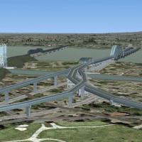
Version 2.00 adds the Olympic pyramid, the cross on Mont-Royal, the locks of St-Lambert, Champlain Bridge, and Honoré-Mercier Bridge, plus roads around the cross, by Sylvain Tremblay. The project r…
 Canada
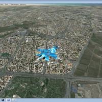
Version 2 of the Mashhad real-photo presentation delivers real elevation and all-season, night capability focused on the Mashhad area, anchored by the OIMM airport. Improvements include city traffi…
 Iran (Islamic Republic of)
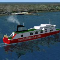
Dynamic models by Terry Shields depict the HSS Stena Line car ferry on Belfast-Stranraer and Dun Laoghaire-Holyhead, plus the Norfolk Line car ferry Belfast-Liverpool, with timetables created using…
 Global (World)
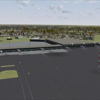
An add-on refines ground structures at Warsaw Chopin Airport (EPWA, formerly Okecie), with upgraded vehicle placements, extra cargo on the ramp, and taxiway routing tuned to mirror real-world opera…
 Poland
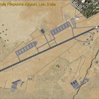
Version 1.3 of Leh Kushok Bakula Rinpoche Airport in Leh, India adds a GPS approach for runway 7 and expands the field with parking, taxiways, aprons, buildings, and roadways. Two helicopter bases …
 India
India
CanarFsX version 1 functions as a flight-simulation enhancement by Toni Agramont, emphasizing the physical details of the Canary Islands and supporting both VFR and IFR operations. This edition pre…
 Spain
Spain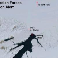
At CYLT near the North Pole, the airfield features a gravel runway 05-31 and a heliport. Designed with ADE 1.37, the layout adds an ice station along with tourist and military ships and icebergs, a…
Canada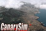
By Francisco Urquia and Luis O. Bethencourt, CanarySim's Xporter handles PROJCA61.ZIP, PROJCA62.ZIP, and PROJCA63.ZIP, transferring their contents into CanarySim/Project Canarias 2006/Terrain - Dat…
Spain
Version 7 of Chile revises SCEL with orientation tweaks and adjusted distances for taxiways, ramps, and gates, aligning with current layouts, and introduces Concepción Airport (SCIE). By J.N. Lucer…
 Chile
Chile
Two variants focus on the DHLComplex CVG and the DHL CArgo Annex at KCVG, offering a placeable option and night lighting for the facility near the Northern Kentucky/Greater Cincinnati International…
 United States of America
Alf B. Meier releases a targeted fix for Philip S. Goldson International Airport in Belize, using BGL files to remove autogen trees from the runway and taxiways. Generated with SBuilderX and Airpor…
 Belize
An airport enhancement for Belfast Aldergrove in Ireland adds updated parking, new objects including a fire station, and a repositioned control tower, paired with revised taxiways to reflect curren…
 United Kingdom
Centered around KBLI in Washington, this depiction adds autogen and night lighting to the airport. Custom buildings replace airport structures, autogen and night lighting illuminate the scene, and …
United States of America
By Robert A. Baum, BC_CARR2.ZIP patches Yanco San's WWII Midway Carrier Battle to run across two versions, aligning its operation with cross-version expectations. The file BC_CARR2.ZIP preserves th…
 United States Minor Outlying Islands
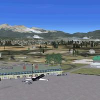
A modified layout at KFLG Flagstaff AZ adds a new terminal, fire station, and updated taxiway signs, along with a fuel truck and small GA fueling station, while representing a nearby ice cream cone…
United States of America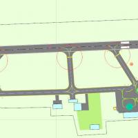
By Matthew Worsley, the AFX file EGJB_ADEX_MW.BGL for Guernsey Airport (EGJB) depicts terminal building, ramp and parking using default structures and reflects accuracy based on photos and imagery.…
 Guernsey
In South Africa, Bloemfontein Airport (FABL) features custom buildings and photoreal terrain that changes with the seasons, delivering varied visuals across months. It works with Bloemfontein VFR v…
 South Africa
Frits Beyer creates content for the harbor at Cape Town in South Africa. The listing includes a folder bearing the harbor name from Cape Town and directs users to place it into a content directory …
South Africa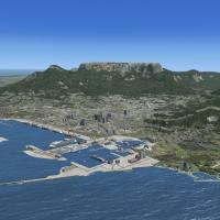
The compilation gathers Kruger National Park, South African Harbors, and Overvaal resorts, plus added power stations and refined background imagery, using default objects and own-designed models to…
South Africa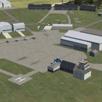
Carlisle Lake District Airport, EGNC, sits in Cumbria, England, as a former WWII airfield now serving civil operations; two BGLs exist, crosswind-enabled or not, named EGNC_ADEX_NUTMEG.BGL and EGNC…
United Kingdom