Page 81
Searches the whole library — filter by sim & category on the results page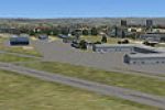
Freeware FAGC_Grand Central.zip delivers a Johannesburg, South Africa airfield representation identified by registration FAGC, built from default library assets. The archive includes a folder named…
 South Africa
Frits Beyer credits the harbor work near Port Elizabeth, South Africa. The update removes the original harbor and introduces a new file that aligns the layout with real-world geography and adds a s…
South Africa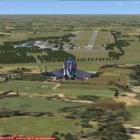
Oldenburg, Germany, appears in a v1 depiction by Uwe Steenweg, using ADE X 1.50 and stock objects. Two .bgl files from the Oldenburg AB V-1 folder reside in this offering, and numerous parking spot…
 Germany
Doug Keech creates a region in northern British Columbia featuring two dirt strips and a seaplane dock along the Kwinamass River, with Big Bay and Union Lake as stops intended for a terrain add-on.…
 Canada
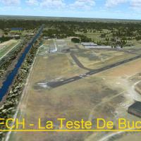
LFCH airfield near Arcachon in Aquitaine, France launches a V1.0 revision crafted with ADE, SbuilderX, and Whisplacer. Developed to reflect its Arcachon area location in Landes, Aquitaine, the upda…
 France
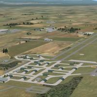
South Africa’s Makhado AFB uses default objects and buildings, while a custom designed layout file is correctly placed to support its new commercial flights, with free library objects by Jaxan Prie…
South Africa
On Aitutaki Airport in the Cook Islands, this freeware project credits Ian Thatcher for the landclass work and Lawrie Roache for object placement, adds a separate landclass file that sharpens the i…
 Cook Islands
The aerodrome near Hamar, Norway (ENHA), features 3D buildings and a photoreal ground with correct landclass, serving operations about 40 miles north of Oslo near Lillehammer. By Thomas Lorentzen a…
 Norway
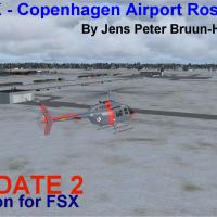
Version two corrects items tied to service pack two and adds a Danish Air Force SAR terminal along with two new hangars at Roskilde airfield in Denmark, credited to Jens Peter Bruun-Hansen. After s…
 Denmark
Roger Leupold presents Jandakot Airport in Western Australia as version 1 under his Aussie Series. The work centers on a single variant and its Western Australia scope, with author credits to Leupo…
 Australia
ADE X 1.50 and stock objects reproduce a base in northern Germany near Tarp and Schleswig-Holstein, between the Baltic and North Seas. Two .bgl files from the Husum AB V-1 folder accompany it, by U…
Germany
An ILS is added to runway 27 at Jacksonville NAS (KNIP), enabling full-stop landings for AI IFR traffic and directing both takeoffs and landings to that runway, with the user ILS tuned to 109.30. T…
 United States of America
A 23-airfield route spans the United States from Provincetown MA (KPVC) to Oceanside CA (KOKB), with no leg exceeding 200 miles. Each field is built with generic objects and includes NDBs, with fre…
 Global (World)
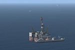
Gas rigs sit in Morecambe Bay, just west of Blackpool in the UK, by Neil Birch. The bgls go in an active scenery folder and the fx file sits in the effects folder inside the main directory.
 United Kingdom
Charlottetown Airport on Prince Edward Island carries IATA YYG and ICAO CYYG and sits about 3 nautical miles north of the city. This remaster uses ADEX 1.45.06 and includes seven BGL files alongsid…
Canada
Kermanshah Airport (OICC) in Iran gains a revised layout with a new taxiway and runway, a control tower with beacon, and multiple navaids. By Ehsan Moradi, it highlights the added infrastructure su…
 Iran (Islamic Republic of)
Pueblo Municipal Airport in Colorado carries the KPUB identifier and hosts the Air Forces Initial Flight Screening Program run by DOSS Aviation. The airfield includes two FBOs, numerous GA hangars,…
United States of America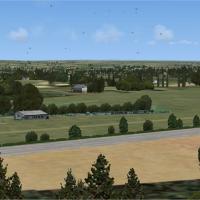
By Alf Denham, Popham airfield (EGHP) near Basingstoke, UK features two grass runways 08/26 and 03/21 and circuits at 800 ft to the north. A water tower stands 60 ft above the field, and only aircr…
United KingdomSoacha VOR provides navigation for Colombia and does not come with default setup in the environment, with attribution to Juan Carlos Cancelado R. This standalone facility, dedicated to the location…
 Colombia
Munich's EDDM receives a total makeover with assigned parking and a lighted helipad, designed with ADE v1.37. A single EDDM.BGL file renders the changes for the default layout, and tower-view persp…
Germany