Page 93
Searches the whole library — filter by sim & category on the results page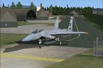
Within the NL2000 v4.02 lineup, a component reproduces the airfield at Soesterberg (ICAO EHSB) as it appeared in the 1980s, by The Netherlands 2000 Scenery Design Team. It depicts runways and taxiw…
 Netherlands
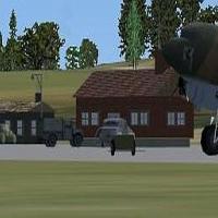
A World War II–era redesign shapes Stronsay airfield and places it roughly 30 nautical miles north of Scapa Flow. ICAO EGER, VOR 114.00, and NDB 330.00 are noted in accompanying materials for refer…
 United Kingdom
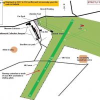
Alf Denham presents Old Warden in the UK as version 2, assigned ICAO code EGTZ, and notes ALFS_OLD_WARDEN_V2.ZIP as a companion file. A range of 8KB and larger BGLs exist, including EGTZ_extra, EGT…
United Kingdom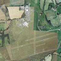
Situated south of London in Surrey, this grass airfield complex named EGKR Redhill features five runways and five or more helipads. Creator Dominique M. L. Donzelot notes it uses existing objects a…
United Kingdom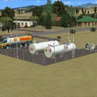
NZMK Motueka sits 1 nautical mile southwest of the town of Motueka, in the Tasman Bay area of the upper South Island. Credits go to Lawrie Roache for Afcad and object placement, Godfrey Tier for si…
 New Zealand
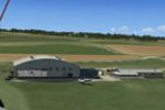
Nearby in northeastern France, the airfield features photoreal ground and seasonal variants, with custom hangars and an animated windsock alongside static aircraft and livestock. It lists compatibi…
 France
CV71 is located three miles southeast of Pensacola NAS (KNPA), Florida, with GPS ID CV71. The ILS heading runs 245 degrees and NAV frequency is 108.15, the archive is a self extracting Zip-File, an…
 United States of America
A harbor project at East London, South Africa, is credited to Frits Beyer. The item is intended for placement in a designated directory and addition to the library for enthusiasts worldwide seeking…
 South Africa
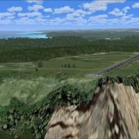
Frits Beyer and Jacques Botha craft a photoreal base for an airfield in South Africa that changes with the seasons. It includes a Port St.Johns(FAPJ) folder and an AFX_FAPJ_ALT.bgl, while an altern…
South Africa
Alexander Czarnecki delivers v1 for YPPH, Perth International Airport in Western Australia, reworking aprons and taxiways and adding codes for parking to support ground operations. A folder named Y…
 Australia
Two BGL options cover the KROC facility in New York, KROC_ADE_RS.BGL and KROC_ADE_CW_RS.BGL, with crosswind runways active in the CW version via ADE v1.37. Each option maintains assigned parking an…
United States of America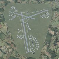
By Chris Smith, the work recreates RAF Stoney Cross using historical data and Google Earth fixes, with UKXX as the airport code and three BGLs named Stoney Main Buildings, Stoney extra buildings, a…
United Kingdom
Divinopolis Airport (SNDV) in Brazil gains a details enhancement by Cesar Marinho Costa, improving the facility in the city of Divinopolis. The author makes the work free to anyone and prohibits sa…
 Brazil
Located in northern New South Wales near Byron Bay, the aerodrome identified as YLIS handles 52 weekly Rex flights to Sydney and features buildings modeled with photo imagery captured at the field …
Australia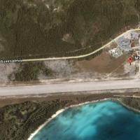
Jimmy R. Martin presents an add-on centered on an airfield on Eleuthera, Bahamas, using satellite data to mirror the real layout. It includes static GA aircraft provided by gaplane1.zip, while nigh…
 Bahamas
Since 1978, Olten Airfield restricts access to gliders and now welcomes all users. The LSPO-Olten-Switzerland folder combines Olten Airfield LSPO and Olten landclass in Switzerland with a few custo…
 Switzerland
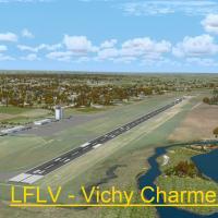
By Stephane Gouzon, the LFLV - Vichy Charmeil project presents a V1.0 airfield modification created with ADE, SbuilderX and Whisplacer. It focuses on the Vichy Charmeil airport near Vichy in the Al…
France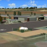
The FATP registration identifies a general aviation airfield in South Africa, where every hangar and building is custom built from designer objects. A high resolution photoreal base changes with th…
South Africa
An enhanced depiction of Hualien in Taiwan adds Jiashan as a modeled extension, with Jiashan configured as Hualien's runway 3L-21R and ROCAF’s 401st Tactical Composite Wing operating F-16A/B fighte…
 Taiwan, Province of China
Hi-res alpine landscape covers the French Alps, with the highest point in the Massif des Ecrins highlighted in the depiction by Frank Dainese. The depiction credits Dainese for the focused represen…
France