Page 104
Searches the whole library — filter by sim & category on the results page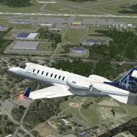
Local airport at Kinston, code KISO, in North Carolina lies near the town’s northeast edge and boasts one of the region’s longest runways. The project overlays a map to correct taxiways and roadway…
 United States of America
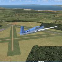
An early version (version 1) by Roger Leupold presents an airport rendition featuring custom objects arranged to mirror taxiways, ramps, and lighting, with runways aligned using Google Earth imager…
 Australia
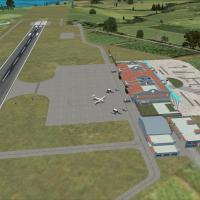
RCFG Nangan Airport on Matzu is one of the two airfields serving the Matzu Islands. Custom buildings derived from the El Formosa Project join newly built structures, while satellite imagery guides …
 Taiwan, Province of China
A private grass airfield in Vendée, west France, features a 550-meter strip suitable for GA aircraft. It sits about 15 nautical miles north of Les Sables d'Olonne, near Saint Gilles Croix de Vie, a…
 France
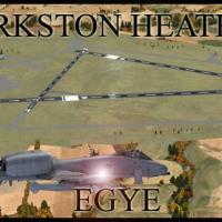
Defence Elementary Flying Training School operates the Slingsby T67M260 Firefly two-seat trainer at the airfield. Two files, EGYE_ADEX_GB.BGL and EGYE_ADEX_GB_CVX.bgl, accompany it and support its …
 United Kingdom
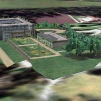
Lyme Park in Cheshire, UK appears in the Castles and Halls series, optimised with Horizon VFR Photographic, Generation X, volume 3, using a 2.4-meter-per-pixel terrain mesh and a 5-meter-per-pixel …
United Kingdom
Marius Risan releases Gullknapp ENGK, a small-airport installation for a rural field near Arendal, Norway, identified by the ENKG code. The author distributes it as freeware and ties the ENKG tag t…
 Norway
An add-on for the South Australian aerodrome YPAG, it upgrades the default layout with objects and a few items from Acceleration. Ian Williams credits the freeware effort, created with Airport Desi…
Australia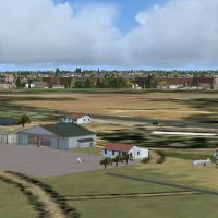
At LFFK in the south of Vendee, a hard runway sits beside the existing grass strip, with a model flying zone and a karting track nearby. Dominique M. L. Donzelot is the author, and the layout is no…
France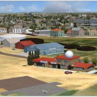
Ermelo Airport (FAEO) in South Africa receives a replica of its buildings, credited to Hannes Steyn and Martin du Preez. It relies on Aeroworx mesh 0604 Part 1-4 and 0704 Part 1-3, requires 1m reso…
 South Africa
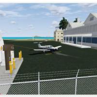
Palm Island anchors the eastern point as a reference while Union Island, part of St Vincent and the Grenadines, features a single runway 08/26 and tower control. The project adds an improved apron …
 Saint Vincent and the Grenadines
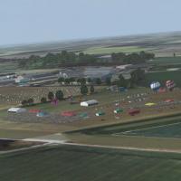
By Trevor Clark, this Rougham airfield rendition targets Volume 2 compatibility and features an optional airshow when the Acceleration Pack is present. It requires several freeware object libraries…
United Kingdom
TNCE_ADE.bgl-File adds gates and parking positions at the F.D. Roosevelt Airport and supports AI traffic, designed for use with default visuals. The file name identifies TNCE, is freeware, version …
 Bonaire, Sint Eustatius and Saba
KLSE in La Crosse, Wisconsin gains a rebuilt terminal with gates and parking for American and Delta, while jetways operate and lighting improves visibility. Rob Touchtone creates the adjustment wit…
United States of America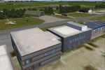
The base at EHLW sits in the northern Netherlands and receives photoreal ground treatment driven by satellite imagery, with detailed structural modeling of hangars and hardened shelters. It fully i…
 Netherlands
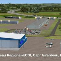
An addon identifies the Missouri airfield near Cape Girardeau with IATA CGI and ICAO KCGI, noting two runways across 557 acres located five miles southwest of the CBD. The add-on includes c182r_rg.…
United States of AmericaLa Macaza in the Laurentides, Quebec, Canada, hosts Mont-Tremblant International Airport (CYFJ) and gains an ADE file that enhances realism for a city-led project for this facility. This change ali…
 Canada
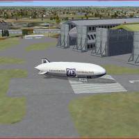
Two BMP files accompany this modification, R101.BMP and R101_LM.BMP, for the static R101 airship, alongside three BGLs—EGRA_ADEX_JM.BGL, EGRA_ADEX_JM_OBJ.BGL, and EGRA_ADEX_JM_CVX.BGL—for airfield …
United KingdomCape Town, South Africa hosts a Caltex Refinery project by Frits Beyer, with the CPT Caltex Refinery file as its identifier. The CPT Caltex Refinery file carries the creator’s name and anchors its …
South AfricaBy Jacques Botha, this Brazzaville-based airport project is built from library objects and mirrors the real site near Brazzaville, Congo. The archive Brazzaville_FCBB.zip contains the Brazzaville_F…
 Congo
Congo