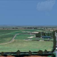
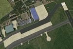
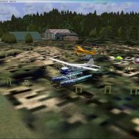
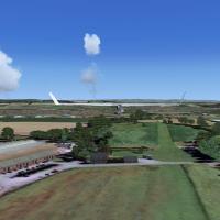
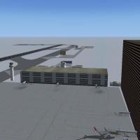
FSX Scenery

Page 128

Sort
Reset
Preview screenshot

Chitina Airport

Chitina Airport (CXC) in Alaska operates as a bush strip featuring a hangar, FBO, loading area, a helicopter pad, and a float plane dock at the northern end of the runway. The scene includes a downed aircraft and pilot downstream, with the associated file named bushstripchitina.bgl.

Country
United States of America
File Size
2.34 MB
Total Downloads
161
Star Rating
1/5
Screenshots
1
No image available.

ADEX For KICT Cessna Facility

At Wichita Mid-Continent Airport (KICT), this file, by Richie1935, replaces default hangars with Gmax-built structures for the Cessna Facility and adds animation to the Citation building doors only. Five separate MDL files govern motion for the five door sets, each tied to a distinct VOR2 frequency such as 117.95, 117.90, 117.85, 117.80, and 116.95.

Country
United States of America
File Size
2.77 MB
Total Downloads
160
Preview screenshot

Tonopah Airport

Tonopah Airport (KTPH), Nevada, gains multiple BGLs that add ramp parking for small GA aircraft, plus roads and assorted objects to better reflect the site, while removing the default boundary fence and applying sloped flattening to blend the airport terrain with the surrounding desert, supported by a 10 m West Coast Version 1.1 terrain mesh.

Country
United States of America
File Size
812.99 KB
Total Downloads
160
Star Rating
1/5
Preview screenshot

Harewood House Fix

By Chris Brown, this Harewood House patch targets the UK location and replaces harwud.bgl when used with HARWUD.ZIP. The harwdfix folder houses the correction, addressing flower pots that migrate to the terrace and restoring the intended layout for Harewood House.

Country
United Kingdom
File Size
307.23 KB
Total Downloads
160
Preview screenshot

NL2000 V4.03 Deelen Air Base

An accurate representation of EHDL near Arnhem presents true-to-life runway and taxiway layouts reflecting the airfield blueprint, while aerial imagery provides authentic ground visuals and surrounding Netherlandic terrain. It integrates with NL2000 v4 framework across the ecosystem.

Country
Netherlands
File Size
95.23 MB
Total Downloads
159
Preview screenshot

Ghost Airports PA Scenery Update 1

Four intermediate lighted airfields from the 1940 Cleveland Sectional Chart, in Pennsylvania, on the New York to Chicago Federal Lighted Airway, gain beacon towers on arrow-shaped concrete pads at each site, with daytime-only operation since beacon signaling is unsupported. Richard O. Finley is credited; .BGL files accompany a revised readme.

Country
United States of America
File Size
15.66 MB
Total Downloads
159
Screenshots
1
Preview screenshot

Flagler County Airport

ATIS and tower frequencies stay accurate, they identify as KXFL, the ground control frequency changes, and the old map designation X47 remains visible. Brighter runway lighting and enhanced approach lighting aid nighttime identification, improving visibility for pilots operating under limited lighting conditions.

Country
United States of America
File Size
420.5 KB
Total Downloads
159
Star Rating
2/5
Screenshots
4
Preview screenshot

Glenview NAS

Located in Illinois, this portrayal centers on Glenview Naval Air Station, which originates as a Curtis-Wright airfield that the Navy renames in 1937. By 1993 the base closes and is dozed, leaving only the main building complex, now a shopping center, and the north hangar used for firefighting, by John Hawranick, Jr.

Country
United States of America
File Size
4.19 MB
Total Downloads
159
Screenshots
1
Preview screenshot

Richmond Municipal Airport

The KRID field in Indiana has multiple runways, with a paved main strip extending 5200 feet. Its elevation reaches 1140 feet, it sits about five miles from the town of Richmond, and Richmond Boac owns the field.

Country
United States of America
File Size
5.1 MB
Total Downloads
159
Star Rating
4/5
Screenshots
2
Preview screenshot

Amougies (EBAM) Airstrip

Near the town of Amougies in Belgium lies the EBAM airstrip, about 610 meters long and 22 meters wide, with two elevation options delivered as bgl files, depending on standard layouts or a custom Belgium IFR mesh, by Weygantt Kurt.

Country
Belgium
File Size
844.57 KB
Total Downloads
159
Screenshots
3
Preview screenshot

Lundy Flatten

By Neil Birch, this flattening targets Horizon VFR Vol. 2 users and corrects the coastline around Lundy in the Bristol Channel, fixing the sea running uphill. It ships as a .bgl file optimized for terrain alignment in that area.

Country
United Kingdom
File Size
310.62 KB
Total Downloads
159
Star Rating
1/5
Preview screenshot

Goodyear Blimp Base Sign

Derek Souza credits the Goodyear Sign placement at the blimp base in Carson, California, with design by Steve Ziegler. A Goodyear Sign BGL and other BGLs exist, with the main files in addon directories and the rest in a global folder.

Country
United States of America
File Size
25.66 KB
Total Downloads
159
Preview screenshot

Urup Russia Airstrip

By Martin Rothenmund, an abandoned airstrip sits on the northern part of Urup in the Kuril Islands, a remote, uninhabited island roughly 60 sm long and 20 sm wide, accompanied by rusty military equipment. A fuel tank is included to support emergency landings or brief stops.

Country
Russian Federation
File Size
2.57 MB
Total Downloads
158
Star Rating
3/5
Screenshots
4
No image available.

Costa Blanca Small Airfields

Airfields include Totana, Los Garranchos (my own field), Los Martinez, Catral, Los Maldonados with a 1100 metre tarmac strip, and Vera Airfield featuring a 400 metre runway. By John Reynolds, Los Garranchos serves microlites across the Costa Blanca south near Torrevieja and Murcia, with Vera located in Almeria.

Country
Spain
File Size
8.3 KB
Total Downloads
158
No image available.

Birmingham Approach Pylons

612 pylons mark the Birmingham International approach at EGBB, laid out along the approach path and aligned with image-based terrain visuals. Neil Cooke crafts a single bgl file that aligns with area-oriented imagery, density remains at normal and road traffic remains enabled.

Country
United Kingdom
File Size
7.33 KB
Total Downloads
158
Preview screenshot

Seven Castles

Seven castles, including Himeji, Kumamoto, Osaka, Edo, E Yatsushiro, Hikone, and Goryoukaku, stand at the foot of Mt. Youteizann in Hokkaido. Harutoshi Nakagawa is the creator, and the arrangement places the seven named castles as a geographic cluster on the island.

Country
Japan
File Size
9.37 MB
Total Downloads
158
No image available.

Bojnourd Airport

Bojnourd Airport sits in Iran’s North Hkorasan, anchoring the scene to a real-world locale. Shahin Najafi earns author attribution, and the site carries the code OIMN, providing a precise reference for geographic identification within that region.

Country
Iran (Islamic Republic of)
File Size
2.99 KB
Total Downloads
157
No image available.

Slupsk Airport

EPSK, Slupsk Airport in Poland, receives a straightforward rework of the military airfield, adding real taxiways, parking positions, a helipad and a runway overrun on the main 27 runway, along with nearby Redzikowo buildings. The modification uses the free ADE X tool, relies on current satellite imagery, and avoids photo textures or custom objects.

Country
Poland
File Size
5.86 KB
Total Downloads
157
Preview screenshot

Ado-Shem

Researchers reveal an unknown ruin in the south-western corner of Egypt, named Ado-Shem, and they speculate the site could lead to the long-lost Giant Pyramid. By Andy Johnston, the narrative presents a challenge to decipher hieroglyphs to locate the Pyramid.

Country
Egypt
File Size
841.11 KB
Total Downloads
157
Star Rating
1/5
Screenshots
1
No image available.

Southampton Heliport

On Long Island, Southampton Heliport (87N) in New York serves as the town’s public helipad. It is the island’s only public helipad outside of an airport and shares a CTAF with Mattituck Airport (21N) to the north, by Drew Sikora.

Country
United States of America
File Size
115.61 KB
Total Downloads
156