Page 137
Searches the whole library — filter by sim & category on the results page
Airstrip 09FA sits near Lake Placid, Florida, a modest field identified by its code 09FA. Runway 18/36 measures 4800 by 50 feet and uses a straightforward layout suited for lighter aircraft, with p…
 United States of America
Tri-Cities Airport, KCZG, in Endicott, New York, gains an enhanced depiction with relocated taxiways, aprons, and roads and replacement of most structures by more accurate versions. Two files, KCGZ…
United States of America
Stocking Island in the Bahamas hosts an addon layout that adds ILS to the main runway and relies on a ball-type approach-lighting scheme, blinking white when high, steady white on the glidepath, an…
 Bahamas
The airstrip near the town of Mitzpe Ramon in southern Israel serves ultralight traffic and bears the identifier LLMR. Bar Rodoy adds a gravel runway and extends the asphalt surface by 80 meters to…
 Israel
At the airport serving Auburn and Lewiston in Maine, Curtis Weeman provides an enhancement featuring two DC-3s replacing two Constellations toward the far end. The creator aims to add life for VFR …
United States of America
Southbridge, located in central Massachusetts, features a small local airport that serves the area. The project centers on a file named SouthbridgeMA.bgl, with credit given to Dick Kittredge for it…
United States of America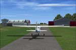
An Oostwold Airport (EHOW) addon blends with the NL2000 v4 framework, requiring the NL2000 v4.0.32 installer for activation and operating within the NL2000 v4.03 lineup. It recreates a compact runw…
 Netherlands
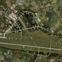
Volkel Air Base, ICAO EHVK, gains a NL2000 v4 expansion that reproduces runways, taxiways, surrounding terrain, and custom hangars with a control tower, while farmland textures and vehicle traffic …
Netherlands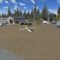
An Alaskan airfield with ICAO code 3AK3 gains a compact, rugged layout for bush operations near Songlo. The upgrade adds six new spawn gates and includes three .bgl files, optimized for SP2, while …
United States of AmericaHarry Patten presents Busselton airport in Western Australia as a faithful rendition, arranging files for an Auto Install option. It relies on a BGL file and uses an Auto Install option to streamli…
 Australia
Cross Keys Airport (17N) in New Jersey is privately owned by Cross Keys Airport Inc. and spans 280 acres, with traffic restricted to the south of Runway 09/27 due to a north-side parachute drop zon…
United States of America
HI03 on Kaui becomes a clay-surfaced airstrip 25 feet wider and 400 feet longer, turning the last strip on the island into a desolate field. Graveyard aircraft and trees may obstruct the runway, an…
United States of America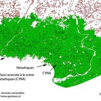
Regis Dassylva authors Natashquan near CYNA in Quebec and releases CYNA2K4 and CYNAFSX as freeware, based on summer 2009 photographs; he notes that some building fronts do not reflect reality, whil…
 Canada
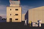
Roo credits this airfield in Wettenhall, Cheshire, UK, with the ICAO code EGCR as the focal location. The entry centers on this site and is supported by imagery depicting the area within the United…
 United Kingdom
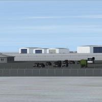
By Brian Sturton, North Star reworks CYNS, a fictional base in the Northwest Territories, Canada, adding two 12,500-foot runways and custom buildings. The airport sits at CYNS, N74 24.8561, W122 03…
Canada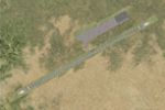
An aerodrome in Kazakhstan, ICAO UAOO, is recreated from satellite imagery with modest detail, featuring parking that mirrors reality and two additional military cargo spots. By Ana Gana, the work …
 Kazakhstan
Gary Cottrill introduces KSFF ADE JV1.bgl, a file that adds a fuel truck to Felts Field (KSFF) in Spokane, Washington. Parking tests with the Beech Baron yield no problems; however, when a small ai…
United States of America
Hawk Nest sits on the southern tip of Cat Island in the Bahamas, credited to Jimmy R. Martin. Two folders accompany it for placement in the addon area, preserving the Bahamian locale and the author…
Bahamas
Jimmy R. Martin offers the 1V6 Pueblo, Colorado add-on, which uses default objects and a ramp light library. It centers on the Pueblo area, and the 1V6 code marks its identity, reflecting a compact…
United States of America
Kingsfield Airstrip, a small landing strip north of Dehkalia in Cyprus, hosts parachute training and shows a jump zone east of the runway. The CX00_ADEX_GB.BGL file implements the addition, with ac…
 Cyprus