Page 32
Searches the whole library — filter by sim & category on the results page
A model of Patoka AO-9 sits at anchor as a mooring mast docking platform across five geographic locations, with airports MPAO Panama Roads, KNAO Pensacola Bay, KAPO Narragansett Bay, VGAO Old Plant…
 Global (World)
Angers-Marce LFJR v4, created by Theo Madzou, centers on Angers-Marce Airport in France and its surrounding area. It includes the airfield and nearby terrain, while noting that the tanker car and p…
 France
Philiadelphia International Airport (KPHL) in Pennsylvania gains numbered gates and assigned airline codes, reflecting its operational layout. The addition includes a UPS ramp along with cargo, air…
 United States of America
Eyguieres/Salon Airport (LFNE) has two grass runways and a short landing strip that suits gliders, with tower control; Daniel Louvet gives visual references because radio navigation equipment is ab…
France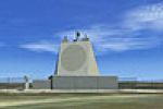
Geoff Smith presents a North England landmark featuring the ballistic missile early warning system perched on Lockton High moor in the North Yorkshire Moors. It references a file named NENGLN1A.ZIP…
 United Kingdom
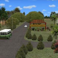
An addon brings Lupepau'u International Airport to life with a detailed layout for NFTV, Tonga, located 75 nm north of NFTL and 173 nm from NFTF. It is designed for SP2 without Acceleration and use…
 Tonga
Tonga
Elbtunnel in Hamburg, northern Germany, corrects the default layout by removing an erroneous bridge across the Elbe River where the tunnel sits. It measures 8 lanes and 426.5 meters in length, dati…
 Germany
A fictional airport with the registration ZZAB is equipped with ILS and standard navaids, and supports ground services such as fuel trucks and other vehicles along with visible air traffic. Michel …
 United Arab Emirates
This is the second Emma Field rendition, a simplified stand-in compared with the original payware. It relies on freeware or default objects rather than original payware, and a separate Airport_Buil…
United States of America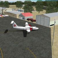
By Daniel Louvet, CYGR on Havre-aux-Maisons sits on the Iles-de-la-Madeleine in the Magdalen Islands, near Cap-aux-Meules, Quebec, Canada. It provides an apron and parking for five aircraft, includ…
 Canada
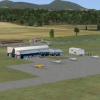
Ken Peters delivers CYCD on Vancouver Island with Nanaimo-Collishaw's complex layout, featuring precise building placements and an updated ground scheme that integrates hangars, terminals, and park…
Canada
Germany-based Calden project marks the second in a planned sequence, adding representations of an office building and hotel in Kassel's West-end and St. John's church in Calden, all built from libr…
GermanyTwo BGL files, KSPS_ADE_RWC.BGL and KSPS_ADE_RWC_CVX.BGL, revise the KSPS airport using ADE 1.37 with stock library objects from the base simulator and its acceleration expansion. Taxiways and ramp…
United States of America
Guido Weiss presents three airfields in eastern Germany, with ED2E Eilenburg, Z11K Juterbog, and a new version of EDBT Allstedt. The freeware offering remains complete and unaltered when redistribu…
Germany
By Ed Wells, the St-Hyacinthe Aerodrome project in Canada sits about 11 nautical miles northeast of St-Mathias and introduces all-new objects for the airfield, relying on default or freeware items …
Canada
By Cesar Marinho, a localizer correction targets SBJF at Francisco de Assis in Juiz de Fora, Minas Gerais, Brazil, using the file APX36390.BGL. A backup of APX36390.BGL is advised, with the replace…
 Brazil
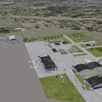
The airfield in Mobile, Alabama, known as KBFM, features two folders authored by Jimmy R. Martin. John L. Woodward's 2004 design provides the detailed buildings, and MOBLBRKL.ZIP must accompany the…
United States of America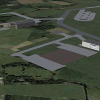
By Lewis Mann, the Shawbury edition centers on helicopter operations, presenting numerous helipads along with hangars and jet parking spaces. It relies on design details from a friend and Rwy12 lib…
United KingdomRoy Perkins presents Catalina Island (KAVX) with nearby airfields including Catalina (KTVX), Pebbly Beach (L11), San Clementa Island NAFL (KNUC), and North Island NAS (KNZY). The file named Catalin…
United States of America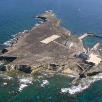
Dominique M. L. Donzelot presents a compact islet layout between Spain and Morocco. Two or three buildings sit beside a small protected harbor with a beach for boat landings, a seaplane facility, a…
 Spain
Spain