Page 41
Searches the whole library — filter by sim & category on the results page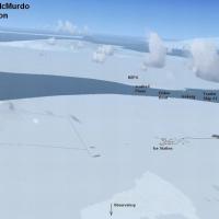
An Antarctic outpost near the South Pole comprises three airports NZPG, NZIR and NZWD, with ice and snow runways about 10,000 feet long. Additional objects include an observatory, two tourist ships…
 Antarctica
A patch for FlightZone02 Portland refines airport configurations, adds exclusions, and replaces older tree files with autogen trees, improving compatibility with Orbx NA Blue PNW. It requires an or…
 United States of America
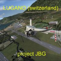
Lugano-Agno's airport LSZA gains depth as Project JBG and Joe Garcia rework taxiways and the tarmac to match real configuration, with most structures generated from Gmax, and the lugano_jbg_v1 fold…
 Switzerland
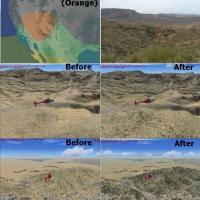
Region C in the Southwestern United States receives a surface swap among 003c2, 009c2, and 051c2 to render a greener shrubscape focused on the majority area. Sedona’s red tones, the Grand Canyon’s …
United States of America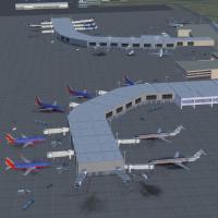
KTUS gains new terminal buildings and re-drawn aprons and taxiways, aligning the airside layout with the real-world configuration to better reflect the site landscape and operational flow. Approach…
United States of America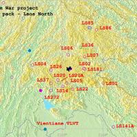
The Laos-focused Vietnam War era project covers 29 airfields near Vientiane, Pakse and Long Tieng, along with 26 Lima Sites rendered onto photoreal ground layouts. By Xavier Carré, it requires VNW_…
 Lao People's Democratic Republic
Jim Jones crafts ten sections of one-meter-per-pixel photoreal terrain data for Lexington, KY, totaling about 600 MB and spanning roughly 245 square miles, LexXP1Ma through LexXP1Mj. Daylight use a…
United States of America
Will Kotheimer provides Longyear Airport assets for Svalbard, ENSB, Norway, featuring original models and boat traffic around Longyearbyen. It requires an expansion to display all components and no…
 Norway
Montego Bay project covers Sangster International Airport (MKJS) and its surrounding area, applying landclass and runway-taxiway-parking changes guided by Google Earth imagery and diagrams by Antho…
 Jamaica
Frank delivers a Mont Blanc enhancement built from genuine aerial imagery, reproducing rugged profiles and snowfields with faithful shading. It coordinates with ItalVFR’s 2 m photoreal backbone for…
 Global (World)
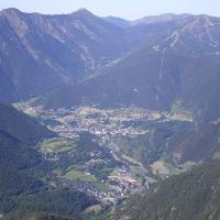
Two heliports and one small runway gain a place in a photoreal depiction of Andorra, located in the Pyrenees. Andy Aundrias delivers this work, with the file name ANDORAV21UP.ZIP, and highlights th…
 Andorra
Seventeen Dutch airports, including EHAL and EHBD, gain parking facilities and taxiways, while Traffic Tools generates a flight plan and AI aircraft for these airports. Most are forgotten by Micros…
 Netherlands
David Sheridan delivers a photoreal depiction covering Perth, Frematle, Jandakot and surrounding areas in Australia, with high to medium detail and no autogen. It remains freeware, permits uploadin…
 Australia
Michael Mannschreck maps a broad area in Southern California, spanning from Los Angeles to San Diego and Riverside, with extensions into Palm Springs and parts of Arizona, plus a feature named Bug …
United States of America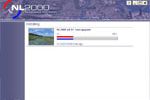
The NL2000 v4.0.20 installer handles NL2000 v4.01 components to expand the Netherlands coverage in a modular, free configuration. The Netherlands 2000 Designers receive credit, and an image file na…
Netherlands
VOBL in Bengaluru, India, opens to commercial traffic on 23/05/2008, replacing the closed HAL Bangalore Airport (VOBG). NAVAID data list ILS for Runway 9 IBAN 109.3 and Runway 27 IDEV 108.3, plus V…
 India
India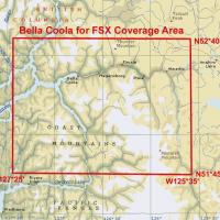
Multi-LOD 38-m mesh and the local landclass, water class, and seasons files cover the Bella Coola area (N51*45'-52*40' W125*35'-127*25'), with accurate placements of lakes, rivers, roads, and strea…
 Canada
A Griffiss AFB installation in New York from the late 1980s features native objects by Jim Dhaenens, using GMAX and the SP-2/Acceleration SDK, including lighting elements such as roundspot, 4litesq…
United States of America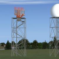
Located at the Italian air base code LIPA, this project uses ADE9X with Google satellite imagery and adds objects to represent hangars, shelters and radar installations. Hangars, shelters, radars a…
 Italy
Italy
Dublin's 2010 layout places Pier A through D with the West Apron and notes F-INN without a T2 area. Overspill parking expands and the cargo area extends, while Gate 36 enlarges to accommodate Aer L…
 Ireland