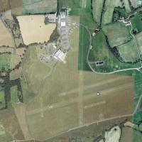
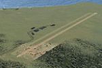
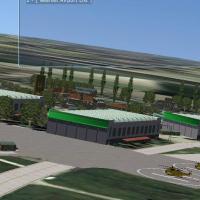
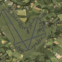
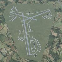
United Kingdom

Page 6

Sort
Reset
No image available.

UK Refineries

FSX UK Refineries scenery inserts accurately placed oil refineries and petro-chemical complexes across England and Wales, giving VFR flyers distinctive industrial silhouettes and cooling-tower smoke stacks for visual fixes. Built with Ted Andrews’ FSX-native objects via RWY12, it aligns with Horizon photoscenery and VFR Terrain mesh.

File Size
2.15 MB
Total Downloads
692
Preview screenshot

Alfs UK Airvields Volume 23

This freeware scenery add-on refreshes three under-represented UK GA aerodromes—Audley End (X3AE), Beccles EGSM and Gamston/Retford EGNE—by adding bespoke FSX SP2-compatible models, supplementary land-class patches and refined placement of stock assets, giving VFR pilots smarter runway markings, accurate taxi layouts and context-appropriate clutter for low-level circuits.

File Size
18.68 MB
Total Downloads
687
Screenshots
11
Preview screenshot

Duxford Airfield

Duxford Airfield for FSX SP2/Acceleration adds the historic Cambridgeshire museum base with custom Dave Garwood hangars, textured ground polys, accurate nav aids and AI flightplans that loop twin Dragon Rapides, while optional static warbirds fill coded stands— a concise UK scenery download for regional coverage.

File Size
953.64 KB
Total Downloads
676
Preview screenshot

EGLC

Revised AFCAD for London City Airport (EGLC) aligns gate numbering with Jeppesen charts, corrects parking headings for AI traffic, and tweaks the short 09/27 runway slope, delivering a UK scenery update that tightens taxiway links and apron geometry for FSX-based pilots.

File Size
1.62 MB
Total Downloads
672
Screenshots
1
Preview screenshot

Dunsfold Airfield

Set amid the rolling Surrey countryside, this Dunsfold (EGTD) scenery add-on for Microsoft Flight Simulator X/Acceleration refreshes the United Kingdom GA airfield with an accurately scaled 07/25 runway, peri track, the familiar Top Gear test loop, bespoke hangars, apron markings, static aircraft and balanced night lighting for realistic VFR circuits.

File Size
37.3 KB
Total Downloads
666
Screenshots
1
Preview screenshot

Alfs UK Airfields Volume 25

This UK set—FSX Alfs Airfields Volume 25—updates Sywell (EGBK) for Flight Simulator X, adding the recently laid concrete runway, updated PAPIs, refined landclass and bespoke structures crafted in Instant Object Studio, ADE and SDK libraries; compiled for FSX SP2, the lightweight addon aligns with default autogen for smooth GA, VFR and training circuits over Northamptonshire.

File Size
8.42 MB
Total Downloads
656
Screenshots
5
No image available.

EGNT

This AFCAD upgrade for EGNT Newcastle Airport, North-East England, restructures gate numbering, reallocates stands, refines taxiway links, and inserts a fuel storage zone plus on-airport fire station, delivering correct parking codes and smoother AI traffic behaviour for Microsoft Flight Simulator X users curating detailed UK airport scenery.

File Size
9.09 KB
Total Downloads
656
Preview screenshot

Alf's UK Airfields Volume 9

Freeware scenery mod for Microsoft Flight Simulator X refreshes Caernarfon EGCK, Deanland EGKL and Perranporth EGTP with revised AFCAD data, sharper runway markings, default-library hangars, static GA traffic and realistic taxi networks—useful for VFR training, coastal cross-country legs and heritage strip operations around Wales, Sussex and Cornwall.

File Size
1.48 MB
Total Downloads
656
Screenshots
11
Preview screenshot

Alf's UK Airfields Volume 11

Focused on the United Kingdom’s smaller strips, Alf’s UK Airfields Volume 11 for FSX refreshes Sheffield City (EGSY), Sutton Bank glider field (XSUT) and Welshpool (EGCW) with custom buildings, accurate runway geometry, revised AFCADs and native library objects crafted from Google Earth and Pooleys data, compatible with SP2 default terrain.

File Size
11.67 MB
Total Downloads
648
Screenshots
11
Preview screenshot

Aberdeen (Dyce), Scotland

Aberdeen Dyce EGPD for Microsoft Flight Simulator X overhauls the stock United Kingdom airport using ADE, matching taxiway geometry, stands and ground markings to current ortho-imagery, inserting a provisional 500-ft runway 16 extension, refreshed aprons, service roads and autogen, creating a dependable base for offshore helicopter sorties, regional jet schedules, VFR circuit work and IFR practice—all library-free.

File Size
1.43 MB
Total Downloads
640
Preview screenshot

Alf's UK Airfields

Alf’s UK Airfields Volume 2 for Microsoft Flight Simulator X upgrades three overlooked British strips—Dunsfold EGTD, Lerwick/Tingwall EGET and Netherthorpe EGNF—by injecting revised AFCAD data, precise exclusion zones, generic hangars, autogen vegetation and corrected runway markings derived from Google Earth and Pooleys guides, creating a subtle but useful freeware scenery enhancement for UK VFR and GA circuit work.

File Size
783.15 KB
Total Downloads
622
Screenshots
12
Preview screenshot

Alfs UK Airfields Volume 17

Alf Denham’s seventeenth freeware scenery set for FSX SP2 refreshes three UK GA fields—Currock Hill (X5CH), Kirkbride (EG86) and Land’s End/St. Just (EGHC)—with bespoke models, revised ground polygons, updated landclass and coastline tweaks, giving VFR pilots cleaner runway alignments and believable clutter without stressing frames.

File Size
13.58 MB
Total Downloads
614
Star Rating
5/5
Screenshots
13
Preview screenshot

Stornoway Airport

This FSX scenery add-on renders Stornoway Airport (EGPO / SYY) on Scotland’s Isle of Lewis with revised runway markings, updated taxiways, coastal terrain mesh and custom HIAL buildings, reflecting its dual civilian-SAR role once shared with RAF. Suitable for North Atlantic hop planning, VFR approaches, mail runs, CHC search-and-rescue sorties and regional airline schedules.

File Size
392.42 KB
Total Downloads
610
Star Rating
2/5
Screenshots
1
Preview screenshot

EGSS

EGSS Stansted AFCAD refresh tunes Microsoft Flight Simulator X’s default layout with real-world gate positions, corrected taxiway links, vehicle pathways, apron light strips, revised control-tower footprint and a helipad start, preventing AI U-turns while aligning stands to current Google Earth data for UK regional hub operations.

File Size
30.94 KB
Total Downloads
604
Star Rating
4/5
Preview screenshot

Newquay Airport

Updated with current ADEX geometry, this FSX scenery converts ex-RAF St Mawgan (EGDG) into present-day Newquay Airport EGHQ, deactivating obsolete taxiways, preserving four real-world runway exits, injecting stand-aligned passenger and GA parking, default structure footprints, and corrected menu naming for authentic Cornwall regional operations.

File Size
115.63 KB
Total Downloads
598
Screenshots
1
Preview screenshot

Derry-Eglinton Airport

Derry–Eglinton Airport EGAE for FSX refreshes this Northern Ireland field with revised GA parking, a re-charted apron adjoining the terminal, CAT I ILS aligned to runway 08, and a dedicated fire-training ground, all compiled from stock assets using ADEX v1.47.07 for smooth drop-in use.

File Size
143.42 KB
Total Downloads
591
No image available.

Penzance Scenery V3

Upgrade Penzance Heliport’s coastal FSX environment with Version 3; dynamic human animations, corrected runway alignment, functional blast-fences, and an enlarged car park integrate seamlessly into Cornish photoreal terrain, sharpening instrument approaches and ramp workflow without straining frame-rates for UK general-aviation sorties.

File Size
123.25 KB
Total Downloads
580
Preview screenshot

Alfs UK Airfields Volume 20

Alf Denham’s free “UK Airfields Volume 20” for FSX SP2 refreshes Priory Farm (X3PF), Walney Island-Barrow (EGNL) and White Waltham (EGLM) with custom 3-D assets, corrected taxiway geometry, landclass tweaks and Google-referenced footprints, giving VFR pilots crisper rural aerodrome visuals without impacting default mesh.

File Size
30.96 MB
Total Downloads
573
Screenshots
12
Preview screenshot

Expanded Dundee Airport

Dundee Airport (EGPN) gains a fictional upgrade for Microsoft Flight Simulator X in this scenery add-on, stretching the runway to 6,000 ft / 1,830 m on axis 09/27, providing ILS both ends, tidied parking nodes, updated landclass, refined River Tay coastline, woodland screening northside and parkland edging the field.

File Size
612.65 KB
Total Downloads
570
Star Rating
5/5
Preview screenshot

Highlevel Barton Bridge

Adds the elevated Barton Bridge spanning the Manchester Ship Canal to FSX, aligning with default terrain, Horizon or Just Flight VFR photographic layers. The landmark sits west of EGCB and aids visual circuits, IFR waypoint planning and realistic VFR navigation across Greater Manchester, Cheshire and Salford.

File Size
4.91 MB
Total Downloads
561
Star Rating
1/5
Screenshots
1

16 pages with 309 downloads.

previous12345678910111213141516next