Page 3
Searches the whole library — filter by sim & category on the results page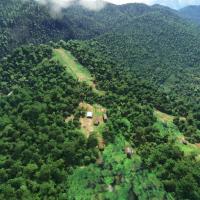
Bambui, designated BCP, sits atop a mountain ridge with a 6850-foot elevation and a dirt runway 1250 feet long that slopes upward toward the western approach. The site lies about 3 nautical miles s…
 Papua New Guinea
Version 3.1 fixes the exclusion of Blackshark AI-generated buildings in Saint-Pierre-des-Corps, ensuring compatibility with autogenerated content, while expanded photogrammetry captures Tours, Fran…
 France
The project models Naval Air Station Joint Reserve Base New Orleans at Belle Chasse, exposing IATA NBG and ICAO KNBG identifiers, plus the Alvin Callender Field name, with 24/7 operations and Coast…
 United States of America
Version 3.0, created by Jeppeson2001, models Monument Valley across the USA region with three files named monumentvalley, monumentvalleyvc, and monumentvalleytiles. It blends into the World Update …
United States of America
Thalixte delivers a rendition of Nice, France, using external map data and hand-finishing for precision, with enhanced 3D building models along the Promenade des Anglais and Monaco to the east not …
France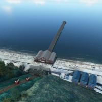
Keith Hackett and Kevin Base lead a hand-crafted, manually placed series of UK piers, created without AI or automation. Saltburn pier features animations and night lighting and overrides the ORBX G…
 United Kingdom
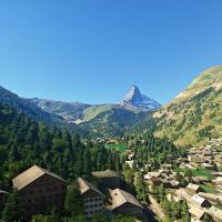
NikPrist delivers a complete overhaul of the Matterhorn Mountain, now at version 2.0, with four LOD levels and four modal areas to boost performance at distance and when viewed from certain angles.…
 Switzerland
On Norway’s west coast, Sandane ENSD presents a sloped runway and an updated apron shaped by current satellite data. Version 0.2.0, dated 27 August 2020, remakes taxi lines and center line, adds mo…
 Norway
A 20 m resolution terrain mesh covers most of Finland, crafted by developer Morko. The package centers on the finland-20m-dem folder and uses data from the National Land Survey of Finland, Copernic…
 Finland
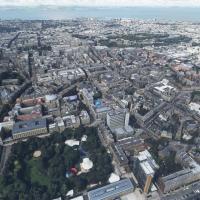
Thalixte provides photogrammetry coverage of Edinburgh and surrounding areas, delivering detailed urban textures and terrain. Two components arrive as folders named thalixte-edinburgh and thalixte-…
United Kingdom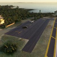
The KCDK facility spans 52 acres and centers on a compact coastal airfield with a 2,355 by 100 foot asphalt runway designated 5/23 featuring displaced thresholds at both ends, and is designed by LK…
United States of America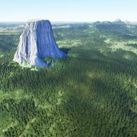
Raimondo Taburet delivers a Wyoming, USA–focused enhancement for Hulett Municipal Airport (W43), adding static aircraft, a few buildings, and painted ground markings. Devils Tower receives a more r…
United States of America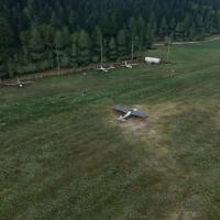
Version 2.0 re-enables the Banff CYBA airfield, adding Cascade Pond and an optional static animal set. Two folders, CYBA Banff Airport and Area and CYBA Banff Animals set, provide daylight and ATC …
 Canada
Thalixte implements an enhanced Dallas area upgrade, incorporating more autogen and a Globe Life Field 3D model near the AT&T Stadium, with 5m height maps for precision. The scope encompasses airpo…
United States of America
By Thalixte, a drop-in replacement for the Charlotte area provides photogrammetry and detailed 3D models of buildings and landmarks. It partitions the region into five named zones—Downtown, East, N…
United States of America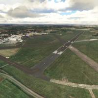
By JayFlySim, Cranfield Airport (EGTC) gains a reworked layout with 3D buildings, a custom ATC tower, and static Boeing 737, while the disused runway is removed and taxiways and aprons are updated …
United Kingdom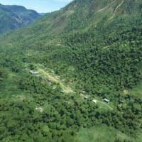
Using a custom object library pbk-huts-n-stuff, 88 airstrips in Highland Papua, Indonesia receive updates, while 20 additional strips stay not included in the base lineup. Google Earth and OurAirpo…
Papua New Guinea
KBVU presents a high-resolution terminal with accurate architectural details reflecting real-world dimensions. The redesigned layout mirrors the current configuration and aligns with aviation chart…
United States of America
KFXE shows custom-modeled Administration Building, presenting a meticulous representation. Enhanced lighting around key structures and a freeware add-on using the latest SDK accompany the overall d…
United States of America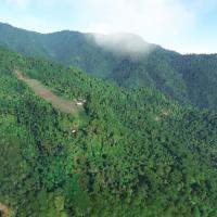
A 1200-foot dirt strip sits at 5000 feet elevation with an upslope and an eastward approach in the PNG highlands. Temporary designation PZ67 replaces a missing ICAO code, real-world access is helic…
Papua New Guinea