Page 51
Searches the whole library — filter by sim & category on the results page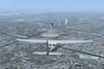
Version 1.0 for Montreal VFR opens in Quebec, Canada, and adds the Olympic pyraminds, a cross on the Royal Mountain, locks of St-Lambert, and roads on the Royal Mountain, enhancing visual landmarks…
 Canada
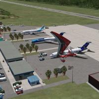
A revision for the Galapagos module enhances SEGS by adding communication towers, rearranging aprons, and placing a hangar with people and other objects. SEST and SEII receive minor corrections, wh…
 Ecuador
LFQK airfield near Chalons-en-Champagne anchors the layout, providing access to a photoreal ground that includes seasonal and night variants. A VAC_LFQK.pdf approach chart accompanies the work, ens…
 France
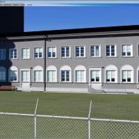
Stas Neznamov presents Estonia's EETN airfield in version 1.0, manually programming it with Cartesian coordinates baisX/baisZ to define the layout. The result covers the Tallinn area with a focus o…
 Estonia
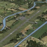
By Geoff Steiner-Scott, this Irish airfield enhancement adds Abbeyshrule, Bantry, Birr, Clonbullogue, Coonagh, Kilrush, Letterkenny, Moyne, Rathcoole, Spanish Point and Trim aerodromes, with Munste…
 Ireland
An arrangement in the Oshkosh area adds objects to seven nearby airfields, anchored by Wittman Regional Airport (KOSH). The collection resides in a folder named Oshkosh WI, drawing from three sourc…
 United States of America
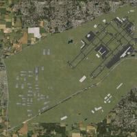
Two BGL files, KIND_ADEX_CJH.BGL and KIND_ADEX_CJH_CVX.BGL, implement corrected ILS alignments for Indianapolis International Airport (KIND) and add GPS-style graphics for the approaches, with all …
United States of America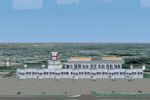
By Huseyin Buharali, the creator uses 3ds Max to build this project from scratch, depicting the busiest airport in Bangladesh with accurate terminal silhouettes, hangars, and parking bays at night.…
 Bangladesh
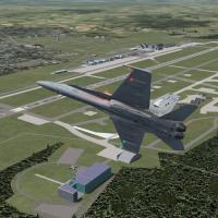
In the second edition expands Misawa AB in Japan, tripling the area and adding hangars, terminals, the main gate, the nine-story residences, and the FLR-9 antenna with Echelon radomes. Most models …
 Japan
Japan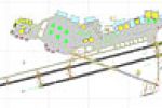
The KNKX Miramar MCAS modification by Timothy Marson adds aprons, taxiways, hangars, helipads and static vehicles to the airfield in San Diego, with static F-22S, F-18S, CHOPPERS, B-52, A-225S and …
United States of America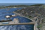
Two airfields, LFVP and LFVM, feature a non-flat runway profile and 2m/pixel photoreal visuals, with Miquelon buildings crafted by Claude Daguerre. The project is by Marc-Henri Guitten, and file na…
 Saint Pierre and Miquelon
Jean-Pierre Fillion presents a Queen Mary 2 route around the world, placing the vessel in ports from Quebec to Yokohama for regular or promotional stopovers. The work highlights a broad geographic …
 Global (World)
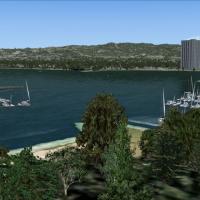
An add-on for the San Francisco Bay Area adds ships, birds, marinas, and a fully functional carrier, with the Acceleration expansion pack required for the carrier, by Orion Lyau. Location aligns wi…
United States of America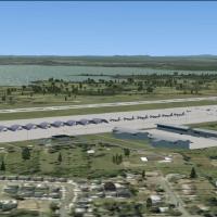
Pease AFB in New Hampshire, version 2.8, sits as a late-1970s SAC base featuring FB-111A, KC-135, and T-37 assets and accompanying flight plans. The setup includes custom hangars, a control tower, …
United States of America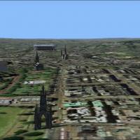
Version 1 offers a photo-based representation of Edinburgh, with night texture included, built with SBuilderX in about ten hours. Coverage spans from the Pentland Hills in the south to the sea in t…
 United Kingdom
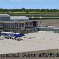
Located in Illinois near Belleville, the base bears IATA BLV and ICAO KBLV designations and is operated by the 375th Air Mobility Wing, with AMC gaining the 932d Airlift Wing and 126th Air Refuelin…
United States of America
Three airports anchor the area: Kangerlussuaq (BGSF), Sisimiut (BGSS), and Maniitsoq (BGMQ), within a 115,500 km2 zone where the coastline, islands, lakes, and rivers receive custom treatments and …
 Greenland
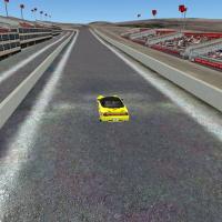
David Sheridan authors a Bathurst area layout for flight simulations, highlighting terrain around the Australian track, the airport, and surrounding town sectors. It references a bathurst folder, t…
 Australia
An add-on for Kelly-Lackland AFB in San Antonio, Texas, adds custom hangars and facilities for C-5s and Wilford Hall Medical Center, with parking coded for MAIW C-5s and F-16s. It requires EZ libra…
United States of America
Manston Airport EGMH gains a detailed layout update with runway 10/28 correctly located and ILS installed at both ends. Parallel taxiways are straightened and a south perimeter track is added, whil…
United Kingdom