Page 58
Searches the whole library — filter by sim & category on the results page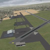
Lee Marrow leads a DGAA Accra airport modification that adds a cargo zone with hangars, warehouses, service vehicles, and designated ramps, and expands parking with relocated spots for smoother tra…
 Ghana
Ghana
The FHAW file delivers a terminal building, a windsock, and a 9-foot correction to the runway length, representing a basic upgrade to the default layout with clarified emphasis on ground infrastruc…
 Saint Helena, Ascension and Tristan da Cunha
Francisco Acosta provides five airfields: Ramey Air Base TJQB, Rossvelt Roads Air Base NRR, Mercedita Airport TJPS, La Romana Airport MDLR, and Culebra Island Old Navy Air Station PR18. The lineup …
 Global (World)
Chania - Souda Airbase, Crete, Greece hosts LGSA, which includes AI aircraft, marking a revision that integrates AI traffic into the airfield setup. An auto installer enables the change, and credit…
 Greece
Roger Leupold delivers a freeware addon released in April 2012 under Roger's Aussie Scenery, rewriting the Western Australian airport with redesigned terminal structures and corrected taxiways alig…
 Australia
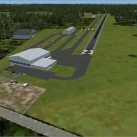
Ed Wells reconstructs five southern New Jersey airfields, replacing ground layouts with satellite-derived placements of terminals and hangars and adding landclass data for regional fidelity. Defaul…
 United States of America
An Antartic-themed compilation presents several fictional airports with images, including YMHB for Hobart, Tasmania, designed for multiplayer hops and playable solo for fans of offbeat virtual trav…
Global (World)An MSPG Mach Loop project for FSX Acceleration SP2 places spotters on CAD East and CAD West and at the Bwlch, with a vantage in LFA7 North Wales to observe approaches. Matthew Kingscott and Scott D…
 United Kingdom
By Sergey Stoyanov, this first step in the Explore Bulgaria project delivers a Bulgaria-area mesh at 38 meters per pixel (LOD10, QMID12) derived from NASA METI ASTER DEM data dated 29.06.2009. The …
 Bulgaria
Version 2.0 corrects the DME issue at KPHX in Arizona, and jetways are visible and operable, made using ADE. Gate assignments reflect current layouts, and Rob Touchtone is credited as the author fo…
United States of America
At KSBA, the data set provides high-resolution ground imagery for the local airport near Santa Barbara and a 150 sq km area around it, with airport-level resolution at 0.3 meters per pixel and surr…
United States of America
RJER in Hokkaido, Japan receives attribution to Shigeru Tomino of Lets Fly Association for the Rishiri Airport feature. It notes the airport's code and geographic context while crediting Tomino and…
 Japan
JapanCraig Tomkins creates the London EGLW heliport in the UK for inclusion in airport listings. It comprises two files named EGLW-fsxsp2-ATSIM and EGLW, serving as a freeware modification that lets use…
United KingdomFuhlsbuttel Airport (EDDH) in Hamburg, Germany, refines taxiways, the terminal, and ground surfaces. Real AI-Traffic parks include Air France at Terminal 1 and Lufthansa at Terminal 2, and it is co…
 Germany
Taxiways and parking at NZCH align with the real-world layout, and an apron and taxiways to the Canterbury Aero Club appear across the main runway from the terminal. Files include Christchurch intl…
 New Zealand
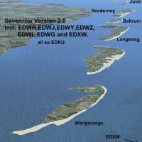
By Ulrich Loehl, a German developer, Seven Row v2.0 targets German airfields EDXW, EDWL, EDWJ, EDWY, EDWG, EDWR, EDWZ and EDKU and introduces a beach on islands together with VFR marker points. It …
GermanyNick Mathews presents a v0.5 course layout in Monument Valley, Utah, featuring pylons, a control tower, and tents. A BGL file named RB Mon Valley Race Course is provided and relies on default objec…
United States of America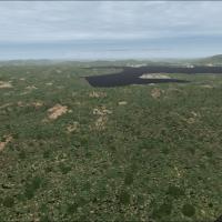
Miguel Calderon authors a Medellin area object addition that includes Avenida 65, Avenida 80, El Tesoro, Walkout Santafe de Antioquia, Fourth Brigade, Palms Highway MDE-BTA, and Penol dam. A Librar…
 Colombia
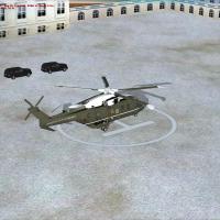
By Justin Sen, this freeware addon places a helipad on the presidential grounds and includes an ambulance and waiting motorcade, realized with ADE 1.47.02 as three BGL files. It notes Marine One la…
United States of America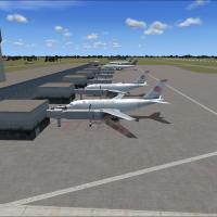
Two BGL files VGZR and VGZR2 accompany an add-on for the airport in Dhaka, Bangladesh, carrying the VGZR designation. By Faisal Nahian, the add-on widens taxiways and expands parking to mirror real…
 Bangladesh