Page 59
Searches the whole library — filter by sim & category on the results page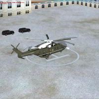
By Justin Sen, this freeware addon places a helipad on the presidential grounds and includes an ambulance and waiting motorcade, realized with ADE 1.47.02 as three BGL files. It notes Marine One la…
 United States of America
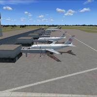
Two BGL files VGZR and VGZR2 accompany an add-on for the airport in Dhaka, Bangladesh, carrying the VGZR designation. By Faisal Nahian, the add-on widens taxiways and expands parking to mirror real…
 Bangladesh
Valladier Jean Louis leads a redesign of St. Eustatius, updating all coasts and landclass and including F. D. Roosevelt airport (TNCE) and the city of Oranjestad, with roads and traffic adjusted to…
 Bonaire, Sint Eustatius and Saba
Langley AFB (KLFI) near Hampton, Virginia receives a detailed enhancement by Jim Cook, reworking taxi routes, ramps, and aprons with AirNav and Google Earth as references. New structures replace mi…
United States of America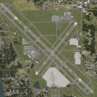
Art Poole creates a freeware enhancement for KSRQ, modernizing terminal facilities, hangars, and aprons based on real-world changes and FAA/Virtual Earth references. It comes with Airport_Buildings…
United States of America
By Karl Meindl, Pensacola NAS KNPA and Whiting Field KNSE in Florida sit near an offshore USS Eisenhower, with GPS CV69 and ILS/NAV 108.30 about 20 miles south of KNPA. Spawn on Helipad 3 and Arres…
United States of AmericaDesigner Andre Johnson outlines an adjustment at DGAA in Ghana, where an extra runway is added to Accra’s airport. DGAA-ACCRA GHANA designates the project, tying the work to the capital and the Gha…
 Ghana
Ghana
Freeware project covers seaplane bases along the U.S. West Coast from Seattle to San Diego, listing Oregon entries such as KAST Astoria Regional and KONP Newport Municipal. It also notes 002A Astor…
United States of America
Version 2.0 improves Midway's Illinois hub (KMDW), resolving a DME display issue and refreshing gate and parking layouts. Jetways are visible and operable, callable to the aircraft via CNTRL-J, whi…
United States of America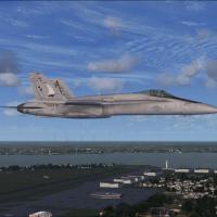
By Dan Mesmer, this enhanced KNIP variant for Jacksonville NAS refines the riverfront with a wharf and steps, and changes apron surfaces to concrete while enlarging several areas. It adds a control…
United States of America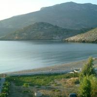
Five waterports in Greece appear under codes LAOR, LIOA, LKAR, LPRS, and LSKY, mapping to Ouranoupoli Xalkidikis, Ioannina Lake, Plastiras Lake near Karditsa, Piraeus, and Skyros. GRcoastlines.BGL …
 Greece
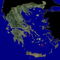
Two Greek islands, Agios Georgios and Anafi, are depicted in GR2-6, which relies on the GR1.ZIP base. The designation GR2-6 anchors the work to the earlier GR1.ZIP and marks coverage of the two loc…
Greece
Ray Smith documents KSAT with four BGL files and a terminal rebuild, noting Terminal 1 now has 16 gates and Terminal B adds 8 gates as Terminal 2 is demolished for the new layout. The four BGLs KSA…
United States of America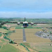
Using 2011–2012 high-resolution aerial imagery, the Marlborough 2015 addon covers Blenheim town and all Marlborough Sounds, expanding the Marlborough region at the top of New Zealand's South Island…
 New Zealand
The BGL file places a carrier off the Hawaii coast near PHNL, along with other ships near the harbor and AI balloons near the Honolulu airport, and it does not affect takeoffs or landings at all.
United States of America
Sainte-Anne-des-Monts anchors the origin of the air venture in Quebec, where Gaston DuPellier starts a war-worn C-47 in 1948, and today his grandson Avelar continues serving small villages along th…
 Canada
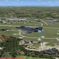
ETSE, v1, Erding Air Base near Munich in southern Germany, is built with ADE X 1.50 and stock elements, including German shelters, the tower, and buildings by Malte Deja and Wolfgang Schroeder. Two…
 Germany
Exeter EGTE expands with Runway 08/26 extended to 7080 feet, a north-side parallel taxiway serving a new apron, terminal, and associated buildings and trees around the terminal, and Runway 13/31 cl…
 United Kingdom
Will Kotheimer delivers a precise rendition of LGLE on Leros Island, Greece, with a Leros folder containing .BGL airfield files and an Effects folder. The field remains uncontrolled, runway 14/32 s…
Greece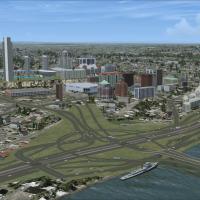
By Brian Sturton, this Albany-area add-on targets 10-metre mesh precision with a 38-metre alternative option, swapping between CVX_ALBANYX.BGL and CVX_ALBANYXalt.BGL to suit elevation behavior. It …
United States of America