Page 73
Searches the whole library — filter by sim & category on the results page
At KSWF in Newburgh, NY, an improved version adds a terminal with jetways, military and GA parking, a fire station with trucks, static helicopters, and revised taxiways and aprons. Two files, AFX_K…
 United States of America
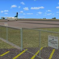
NZNP, known as New Plymouth Regional Airport, sits on the North Island’s central west coast in Taranaki. It runs on SP2 without Acceleration, with Vector Landclass VLC installed, and uses Flight1 S…
 New Zealand
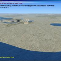
Elevation data with mesh LOD10, land cover, water polygons, rivers, streams, lanes and shorelines surround Nunavut airports in Canada. Mary River runway CMR2 (N71 19 27 W79 21 25) is included, and …
 Canada
Ahmed Al Jaber (OKAJ) sits 75 miles from the Iraqi border, south of Kuwait City, and is depicted as it stood in 2001–2002 with enhanced areas around the flightline. Object libraries include ez_c130…
 Kuwait
Located in Korea’s southwestern region, Muan Intl (RKJB) sits and features a single north-south runway 01/19 with ILS on both ends and ALSF-1 lighting, plus a parallel taxiway to the ramp, since it…
 Korea, Republic of
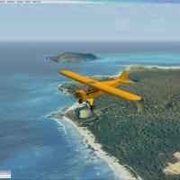
Creator Scott Armstrong releases version 2.0 of a photoreal depiction of the western Hawaiian island off Kauai, with a ground resolution of 1.19 meters per pixel and seamless water blending. The wo…
United States of America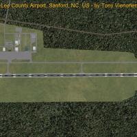
KTTA, a public-use field northeast of Sanford, North Carolina, is owned by the Sanford-Lee County Regional Airport Authority and carries a new designation within the Sanford-Lee County area. The ch…
United States of America
This stand-alone landclass file merges with the default environment or with other landclass sets such as Cloud9 and FS Genesis. In the United States, green mountains give way to rocky terrain, whil…
United States of America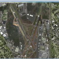
New Jersey’s Teterboro Airport (KTEB) sits across the Hudson River about 12 miles from midtown Manhattan as a general aviation reliever with no scheduled airline service and a 100,000-pound cap, wh…
United States of AmericaBy Robert Fitz, this TNCM runway fix changes the orientation from 9/27 to 10/28 and introduces radar through the TNCM_ADE_DS.bgl file. The change hinges on a single BGL item applied to the airport …
 Sint Maarten (Dutch part)
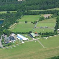
Jon Masterson creates EDKL Leverkusen-Kurtekotten as version 0.4, the first airfield built with a design tool. It uses standard library objects, so the appearance and colors of buildings differ; a …
 Germany
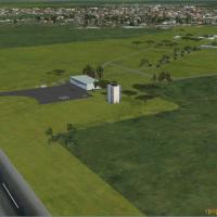
Six remote airports lie along the eastern slopes of the Andes in Argentina, including Andalaga, Belen, Fiambala, Frias, Tinogasta, and Chamical. All new objects appear with a single included librar…
 Argentina
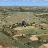
Buchel air base sits near the Mosel in Rhineland-Palatinate, hosts Jagdbombergeschwader 33 and Tornado operations, and remains active. A lite variant omits trees and other frame-reducing elements, …
Germany
Gera Godoy Canova presents four photoreal villages along tributaries of the Peruvian Amazon, with some sites featuring small airfields and others offering deep grass landing areas. Folders hold .bg…
 Peru
Peru
Del Caribe Airport (SVMG) anchors a Margarita Island layout, with Margarita Air Races Airport (MIRA) and nine CSP Race Gates tied to VORs 108.00–108.80 plus MIRB, MIRC and MIRD, while trafficcsp.bg…
 Venezuela (Bolivarian Republic of)
A KNFW upgrade adds expanded military parking with dedicated spaces for cargo and combat aircraft, plus a functional fire station and helipad placements that support rotorcraft operations. Two BGL …
United States of America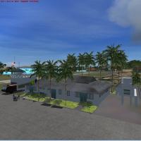
Five Caribbean islands—Canouan (TVSC), E. T. Josua (TVSV), J. F. Mitchell (TVSB), Mustique (TVSM), and Union I. Int (TVSU)—receive redesigned roads, coastlines, and landclass across principal islan…
 Saint Vincent and the Grenadines
In Eugene, Oregon, Mahlon Sweet Field receives version 2, removing runway 3-21 and adding 34R-16L, with corrections to 34L-16R end descriptors, taxiways, and terminal alignment. Two bgl files, KEUG…
United States of America
By David Roch, the volume centers on the Hawaiian island of Oahu, covering airports PHDH, PHHI, PHNG, and PHNR. It introduces birds that appear during takeoff and are visible when Advanced Animatio…
United States of AmericaTwo BGLs exist for YSSY ADE, YSSY_ADE_RS.BGL and YSSY_ADE_CW_RS.BGL, credited to Ray Smith, using ADE v1.37. The CW_RS version activates crosswind runway 7/25 for full operation, while the RS varia…
 Australia