Page 74
Searches the whole library — filter by sim & category on the results page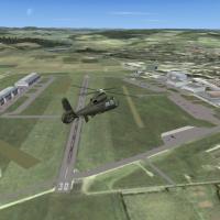
ETHF Fritzlar operates as a military airfield and serves as the base for Heeresfligerregiment 36, aligning the installation with German forces in the Fritzlar area. It optimises use with VFR German…
 Germany
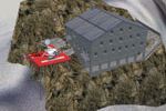
Two alpine huts, cabane des Vignettes and cabane de Trient, include a helicopter landing platform, by Sunny Tanner and Valentin Rime. A folder named vignettestrient holds the assets, with huts loca…
 Switzerland
KRSW in Fort Myers, Florida receives an extension to the existing airport, adding a midfield terminal building and a complete taxiway system to serve the new terminal, enhancing taxi routes and ter…
 United States of America
Two QE2 variants exist: a static docked model at Southampton and a moving version tracing a Southampton-to-Naples voyage. GMAX powers the models, and they align with Generation X VFR Photographic V…
 United Kingdom
Rhett Browning presents a GMAX rendition of MPDA in David, Panama, with structures positioned at precise locations, added PAPI and night lighting, and a reworked parking/taxi network supporting air…
 Panama
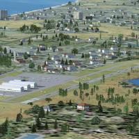
Public airport code 26N lies two nautical miles southwest of the central business district of Ocean City in Cape May County, New Jersey, USA, and Christopher G. Clawson authors the credited work. S…
United States of America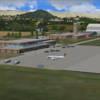
In Lesotho, FXMM, by Jacques Botha and Frits Beyer, shows a fully customized layout with terminals, hangars, and admin buildings, while a seasonal backdrop accompanies the edition and a Moshoeshoe …
 Lesotho
Cork Airport EICK in Ireland receives updates to T2 with jetway to gate 10, a new tower, and revised vehicle paths with updated main apron parking around the airport. Created by Padraic O hEithir u…
 Ireland
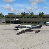
Art Poole delivers an airport enhancement for a Florida facility with code KAPF, updating terminal footprints, taxiways, and landclass along the southwestern coast. Two BGL files, Airport_Buildings…
United States of AmericaPopgrad Airport (LZTT/JVX) in Slovakia is enhanced by Joost Visser. An LZTT_JVX folder and a PDF with AIP charts for LZTT are included, with the PDF described as quite large and slow to load overall.
 Slovakia
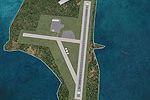
Midway Atoll's Henderson Field (PMDY) gains full night lighting and several objects, created by George Power. Version 1.0 targets a default configuration, with the folder PMDY Henderson Field servi…
 United States Minor Outlying Islands
An enhanced variant of Fairchild AFB (KSKA) is designed for stable rendering, with taxiway lines that stay flicker-free and buildings formed from generic textures. Unmodified Microsoft library obje…
United States of America
Mont-Joli, coded CYYY, sits about 1.5 nautical miles north-northwest of Mont-Joli, Quebec. Historically, RCAF Station Mont-Joli features three paved runways and fifty buildings; it is decommissione…
 Canada
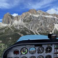
Frank creates an enhanced photoreal rendition of the Tofane massif with Raimondo providing support, using carefully processed photography and an elaborated graphic production approach to preserve e…
 Italy
ItalyRay Smith presents two YBBN variants, each delivering a BGL file, with one activating the crosswind runway 14/32 and the other keeping the default layout. The files are YBBN_ADE_CW_RS.BGL and YBBN_…
 Australia
An alternative depiction of the Temple Mount in Jerusalem portrays the second Jewish Temple as renovated by Herod and later destroyed around 70 CE after 420 years, derived from a scale replica disp…
 Israel
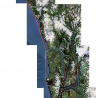
Three .bgl files deliver naval traffic around Alaska, featuring Ark Royal, Clemenceau, and USS Nimitz v2. The trio relies on these carriers being present and stays compatible with UTX Alaska, with …
United States of America
DominicaX, created by Zev C. Richards and Jean Louis Valladier, delivers over 750 square kilometers of photoreal coverage with hand-placed autogen, objects, and traffic. Airport representations are…
 Dominica
The second edition covers important VFR waypoints in South Africa and highlights the Northgate dome and the Silver Ball in greater Johannesburg. It remains freeware and is built from a custom desig…
 South Africa
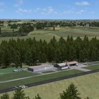
The Vogtareuth airstrip (EDNV) sits in front of the Bavarian Alps in Germany, by Andreas Jennerwein. A rotating Windsock from FSDevelopers is present, and users with photo-based visuals active shou…
Germany