Page 84
Searches the whole library — filter by sim & category on the results page
Two fixes address Istanbul Ataturk Airport and Sabiha Gokcen International Airport, authored by Serdar Nuzhet, using LTBA2009.ZIP and LTFJ2009-1.ZIP to replace with the original files for each loca…
 Turkey
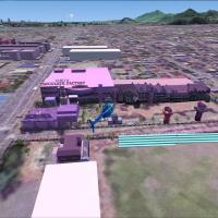
Harutoshi Nakagawa directs a two-year effort to recreate Sapporo City on Hokkaido, the northern island of Japan, using Gmax. A component named naka_sap_effect_fsx is included in the project as a na…
 Japan
Japan
Georgetown, Texas airport enhancement by Matthew Hollcraft uses ADE 9X to modify the default layout, incorporating Kevin Burns’ static aircraft library and Jim Dhaenen’s t-hangars. It adds custom b…
 United States of America
The project centers on an airfield near Husum on the North Sea coast, northern Germany, tracing its wartime origins to British occupation and a 1959 transition to the German Air Force. The unit beg…
 Germany
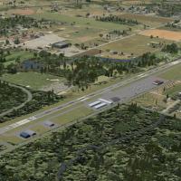
N87-registered airfield sits in Robbinsville, New Jersey, hosting Air-Mods Flight Training Center and Aviation Charters, Inc. Static aircraft originate from a freeware collection by KB Sims, while …
United States of America
Toledo Express at KTOL receives an upgrade that reworks the terminal and adds moving jetways (CNTL-J), military parking on the east side, and a cargo terminal with proper parking. Creator Rob Touch…
United States of AmericaPhotoreal visuals enhance the island with basic autogen and a newly added airport alignment to match the visuals, while no alterations affect the airport area itself. The presentation emphasizes a …
 Nauru
Nauru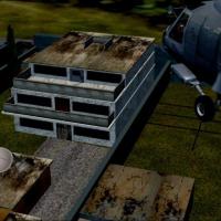
An accurate reconstruction of the hideout in Abbottabad, Pakistan, identified as OSMA, appears in version 1.1 with a landable roof on the main building. The Military Aviation Organization credits C…
 Pakistan
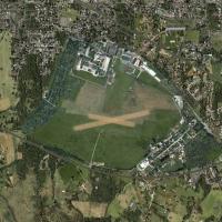
Created with the FSX SDK, Elblag aerodrome runs in dx10 mode. Seasonal variations appear in the visuals and the overall implementation emphasizes a steady, neutral presentation, avoiding promotiona…
 Poland
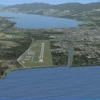
An FSX-compatible patch by P. Nigel Grant converts John Stinstrom and Ray Lunning FS2004 Penticton Airport (CYYF) to FSX, using SBuilderX for corrections and ADE to translate two traffic bgl files,…
 Canada
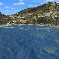
Set around Cape Town, South Africa, Frits Beyer delivers Houtbay Harbor as a regional addition, with a required sequence including Cape Town Harbor, Simons Town harbor, Robbin Island, and Koeberg P…
 South Africa
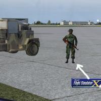
The KSPI facility in Springfield, Illinois, is credited to Jimmy R. Martin and includes objects, people, and lighting. gaplane1.zip, a ZIP archive, is required for some aircraft and supports a smal…
United States of America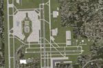
Compatibility fix for the KTPA facility in Florida addresses ATC and ILS issues noted in the original setup and is designed for compatibility with KTPAXFUL.ZIP, with Brandon DePalo as the author. I…
United States of America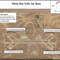
HL77 in Libya presents two parallel runways 10L-28R and 10R-28L, sparse desert surroundings, and four camp areas housing 10-12 hardened aircraft shelters, with fictitious navigational and ATC aids.…
 Libya
Libya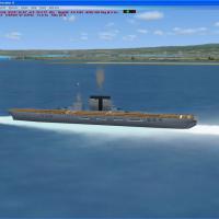
A WW2-era carrier model features a hard deck for catapult and arrestor-gear operations. It sits just outside Pearl Harbor, with Sara.bgl and Sara.xml relocation files plus SaraVX.zip to move the ve…
United States of AmericaSerdar Nuzhet crafts a LCEN depiction of Ercan Airport in North Cyprus from scratch, adding animations, effects, photoreal terrain and night lighting. Navaids and ILS appear, with Serdar Nuzhet cre…
 Cyprus
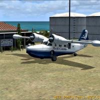
A representation of Tern Island in the Northwestern Hawaiian Islands is built with SBuilderX and corrected with Airport Design Editor, and includes two custom objects—the Tern Island sign (Gmax) an…
United States of AmericaBy John J. Thuot II, a Rhode Island fix enables Zone 01 to function within the base installation, using two airport layout files named FlightZone01_LC and FlightZone01_SC for the LC and SC variants…
United States of America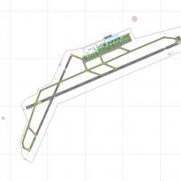
A Palermo LICJ enhancement is designed with ADE v1.47 for the base airport. Parking positions are renamed per the airport chart, jetways are added at gates, and a fire station with a fire truck is …
 Italy
ItalyBiak City, designated by WABB, centers on the urban area of Biak in Indonesia, and this framing keeps the focus squarely on Biak's urban core. The note confirms Biak’s urban focus and implies no br…
 Indonesia