Page 85
Searches the whole library — filter by sim & category on the results page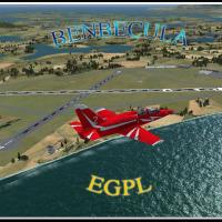
Benbecula Airport (IATA BEB, ICAO EGPL) sits on Benbecula in the Outer Hebrides and is owned and maintained by Highlands and Islands Airports Limited. By Gordon Barnes, the BGL file EGPL_ADEX_GB.BG…
 United Kingdom
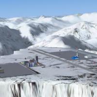
On the Alaska–British Columbia border, Mountain Top (CYMN) sits as a fictional high-altitude airfield a few dozen miles from Juneau at 6800 feet. The locale includes a detailed city, with credit at…
 Canada
An FSX-focused environment by Siscot Yves recreates Red Bull Air Race pylons and terrain changes around Windsor, Ontario, along the Detroit River. It blends satellite references with handcrafted mo…
Canada
KORD in Illinois renames runway 9R/27L to 10/28 and adds the new 9L/27R, with the former 9L/27R becoming 9R/27L. Airport Design Editor X V1_45 shapes three files: DR7_KORD_CVX.bgl (airport boundari…
 United States of America
Gibraltar AB LXGB introduces fuel trucks, expands parking and gates, and refines the apron, taxiways, and runway for this airport location. Blast fences are not included, as they do not look good i…
 Gibraltar
Kenichi Ochiai authors a Japan-focused locale anchored at N35.12'39" E136.40'45", and RJNA Nagoya serves as the designated destination, guiding navigation toward the Nagoya area, and this record em…
 Japan
Japan
The airfield in Toughkenamon, Chester County, Pennsylvania carries the N57 designation and is documented by Christopher G. Clawson. It integrates static aircraft from KB Sims and the Small Airstrip…
United States of America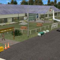
On Niue Island, this add-on for the Hanan air facility uses VECTOR LANDCLASS (VLC) and remains freeware for personal, non-commercial use. Credits go to Lawrie Roache for object placement and to Rob…
 Niue
Niue
The VOPB Port Blair variant extends a lone runway with added parking areas and a runway extension. Modelers add a hill before the runway 22 threshold to reflect real topography, and four VOP named …
 India
India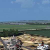
Portsmouth Airport in the United Kingdom carries the registration X2PM, formerly EGHP. The version integrates both older and newer terminal areas, includes a representation of the Airspeed factory,…
United KingdomWest Virginia content by Richard L. Hill provides statewide LWM and VTP data, with support from Chris Wright and his AutoAsm, TerraScene, and USGS data files. The coverage area is defined, and edit…
United States of America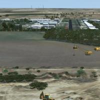
Manny Mahadevan delivers an add-on for the 52F Northwest Regional airport near Roanoke, Texas, released as Version 1.0 on July 8, 2008. It requires SP1 minimum, with SP2 needed to enable certain el…
United States of America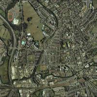
Pips Perez renders Guildford, Surrey, United Kingdom as a photoreal depiction of the town. The gu1 folder sits in your designated add-on area and activates through the library, with daytime lightin…
United Kingdom
By Jim Cook, the revision adjusts aprons, taxiways, and roads while replacing most default buildings and adding a fire station, parking lots, static vehicles, aircraft, and lighting poles. Two BGL …
United States of America
Vince Marrone expands the Fresno metro area by adding static aircraft, vehicles, and hangars to KFAT, KFCH, and E79. The revision also adds Chandler airport and Sierra Sky Park, notes a dam and mar…
United States of America
Frits Beyer documents a custom model of Koeberg facility near Cape Town, South Africa, built from photographs found online. The project references the surrounding harbor areas, requiring Cape Town …
 South Africa
By Bruce Bouley, the 0FD6 designation near Ballard Cove adds a seaplane dock, static seaplane, a medium marina, resort hotel, and estates close to Sebastian, Florida. Coordinates are N27°54.45', W8…
United States of America
An active BGL-based setup activates fireworks displays for Canada Day with an XML source providing GPS coordinates for each site and timing marks such as HOD=22,22 and MOH=15,55. The coverage spans…
Canada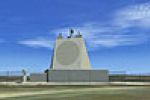
Geoff Smith presents a North England landmark featuring the ballistic missile early warning system perched on Lockton High moor in the North Yorkshire Moors. It references a file named NENGLN1A.ZIP…
United Kingdom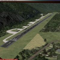
Bern, Switzerland, in the Obersimmental region of the Bernese Alps, hosts a single runway that opens annually for hunters and old timers. A main hangar is added, and the layout relies on RARON.ZIP …
 Switzerland