Page 90
Searches the whole library — filter by sim & category on the results page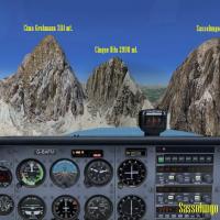
By Frank, this ItalVFR-oriented addon for the Trentino region uses real images captured by a local pilot to reproduce the Sassolungo peaks with 2 m photorealistic detail. It uses an advanced produc…
 Italy
Italy
KGSO in North Carolina receives a thorough revision featuring repositioned taxi lanes and links to R5L, the dedicated FedEx runway, by Jimmy R. Martin. At night, street lights cross near R5L, and t…
 United States of America
Two bgl files exist for this SASA project in Salta, Argentina, with charts covering airport, SID, STAR, and IAC. Cristóbal Laje is credited in 2009, and the work remains freeware with artificial li…
 Argentina
Valera Airport (SVVL) in Venezuela features a corrected runway 03-21 position, shifted roughly 3800 meters to the east of the erroneous default. A detailed terminal building, control tower, firemen…
 Venezuela (Bolivarian Republic of)
A carrier formation near Oceana NAS updates to version 2.0, adding arrestor cables, choppers on deck, and navaids. Located 12 nm northeast of Oceana NAS, it lists a 401.0 NDB with 100 nm range and …
United States of America
An Alaska waterway adjustment repositions Wilson Lake AK to its correct position and size, and redraws Wilson River to blend with the surrounding mesh and terrain features. The river widens and bec…
United States of America
A Warsaw-area aerodrome layout presents more than twenty custom buildings, reflecting period-inspired design. The fictional ICAO code EPPM marks its identity, and AI traffic is provided by Nils Mei…
 Poland
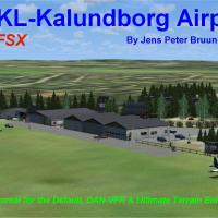
Two editions of EKSS enable Kalundborg’s real-world layout, including EKKL for the Default version and EKKL for DAN-VFR Danish photo coverage with Ultimate Terrain Europa X, accessed via the EKKLX.…
 Denmark
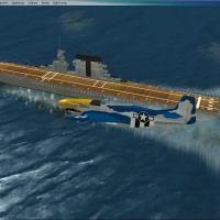
By transforming Paul Clawson's Saratoga model from a static object into a movable AI carrier, this tweak adds a World War II era vessel with AIShips and Arrcab 2.6 integration. The operation relies…
 Global (World)
Located on an ocean beach near Copalis Beach in Grays Harbor County, Washington, the airport bears FAA LID S16 and stands as the only U.S. facility on an ocean beach. Its runway comprises a 4500-fo…
United States of America
KPWT in Washington, by TimTom Productions, depicts a FBO, hangar, cargo parking, glider club, and animated figures, with a bear behind runway 19 and a hot air balloon above the field. The file requ…
United States of America
Version 1.1, called Flores Upgrade, targets Flores Airport (SWFN) in Manaus, Brazil, and replaces the old version; the nearby Ponta Pelada Airport (SBMN) marks the general area. The airstrip serves…
 Brazil
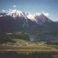
Joe Solomon crafts an accurate approximation of CYYD, a British Columbia airport serving the Smithers area, using an object placement tool. A compiler converts XML mission files to a permanent bgl …
 Canada
At Atlanta’s KATL, a Delta hangar project resides, created by Tyler Newport. It bears a license that prohibits profit use without the creator’s consent, and it ties to Georgia, establishing its geo…
United States of America
By Frits Beyer, this Sun City depiction centers on Sun City, South Africa. Pilansberg Airport (FAPN) serves as the starting point, and the route directs a westward leg of 8nm to locate the site, pr…
 South Africa
Version 5.0 adds three GPS-tagged offshore platforms and three more, with stock sites marked by NDB and VOR for navigation across the U.S. and Mexico. Locations include Corpus Christi (KNGO) with V…
Global (World)
KBED at Bedford, Massachusetts, gains an improved layout with adjusted aprons and taxiways, replaced buildings, and added parking, static vehicles, aircraft, and light poles to better reflect real …
United States of America
Texel Airport, located on Texel island in the Wadden Sea region, receives an NL2000 v4.0-compatible enhancement by The Netherlands 2000 Design Team. It adds photoreal ground imagery, a precise airf…
 Netherlands
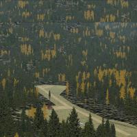
An I08 variant by Erik van Onselen sits at Cabin Creek USFS in Idaho, updating the layout with runways, aprons, buildings, roads and parking areas. Shape polygons replace standard surfaces for the …
United States of America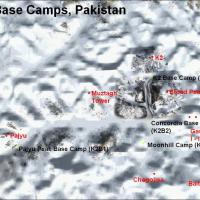
Four camps line the Baltoro Glacier near K2 in Pakistan, named B1 to B4. B1 features a temporary small gravel runway with stone marks at about 3400 m; B2 is the largest camp at roughly 4600 m and h…
 Pakistan