Page 92
Searches the whole library — filter by sim & category on the results page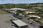 Patch
PatchA patch for PR_AIRPORTS_V2.ZIP, authored by Fred Guerra, accompanies pr_airports_v2_fix.zip and targets the Puerto Rico airport collection. It replaces grass with asphalt surfaces at ABO, Arecibo, …
 Puerto Rico
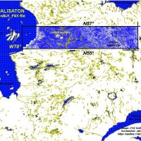
Geographically, the collection covers the Quebec lakes region between N55–N57 and W66–W78 in Canada, authored by Gilles Gauthier. It includes BGL files in a folder set labeled by NW coordinates and…
 Canada
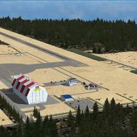
RJEZ in Hokkaido, Japan hosts a Taiki facility conceived by Shigeru Tomino of Lets Fly Association. An accompanying JPEG image illustrates the buildings on the site, offering a visual reference to …
 Japan
Japan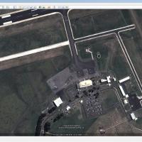
Devonport, designated YDPO in Tasmania, Australia, gains realism through two BGL files named AFX_YDPO.bgl and YDPO_Lib.bgl by Uwe Schweitzer. Autogen and AI traffic support come from AU Traffic fre…
 Australia
A tall red-and-white mooring mast stands between runways 11 and 36 at NAS North Island in San Diego, California. The Mast.ZIP is designed to integrate with NAS North Island KNZY installations and i…
 United States of America
Andres Ramirez writes about Mitu Airport, located at SKMU in Mitu, Vaupés, Colombia, establishing the location, the code, and the attribution. The two facts anchor a compact, factual record that ce…
 Colombia
By Daniel Louvet, Nanaimo area facility expands the terminal and adds north and south maintenance hangars, while a control tower updates the layout and an NDB serves runway 16 on Vancouver Island. …
Canada
Creator Chris Carel, known as MoCat, offers a fix for the Caribbean-based seaplane tour assets, with the Aces Team reworking Marathon and Key West, and pairs with CSPTCW.ZIP to resolve Alpha Channe…
United States of America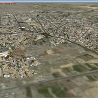
OIMS, Iran, appears in version 1 with hangars, buildings, and added lighting and night illumination. It offers photoreal ground visuals featuring winter and night, plus traffic in the adjacent city…
 Iran (Islamic Republic of)
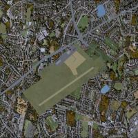
Five Saxony airfields appear with Zwickau EDBI, Auerbach EDOA, Chemnitz/Jahnsdorf EDCJ, and Grossruckerswalde EDAG, plus Hartenstein EHST, a fictional field. Hartenstein lacks an ICAO code and is n…
 Germany
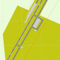
Utah’s new KDXZ field replaces the old mesa-top airport west of town and opens in January 2011, positioned southeast of the city. Ralph Danielson is credited for the work, with materials identified…
United States of America
Michael Allen-Andrews creates a coastal area rendered in 2.5-meter photoreal fidelity, balancing light and shadow to convey depth along the shoreline. The result sits within the 90_mile_beachX fold…
 New Zealand
Ambalema VOR delivers a Colombia-based navigational beacon, broadcasting on 112.7 MHz to support approach and en-route planning for the Ambalema area, with the operational data stored in the file a…
Colombia
Three airports anchor this project: KWHP Whiteman in Los Angeles, KTLR Mefford Field in Tulare, and 1Q1 Eckert Field in Strathmore, the latter split into five WWI sectors. Eight AI aircraft fill th…
United States of America
Big Mamma appears in Oahu, Hawaii, as the third volume in a birds-focused set by David Roch. The release provides two install paths based on MegaScenery Hawaii ownership, directs bgl files to a ded…
United States of America
Within the NL2000 v4.02 lineup, a component reproduces the airfield at Soesterberg (ICAO EHSB) as it appeared in the 1980s, by The Netherlands 2000 Scenery Design Team. It depicts runways and taxiw…
 Netherlands
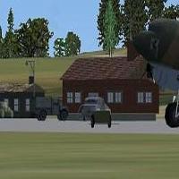
A World War II–era redesign shapes Stronsay airfield and places it roughly 30 nautical miles north of Scapa Flow. ICAO EGER, VOR 114.00, and NDB 330.00 are noted in accompanying materials for refer…
 United Kingdom
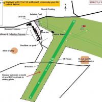
Alf Denham presents Old Warden in the UK as version 2, assigned ICAO code EGTZ, and notes ALFS_OLD_WARDEN_V2.ZIP as a companion file. A range of 8KB and larger BGLs exist, including EGTZ_extra, EGT…
United Kingdom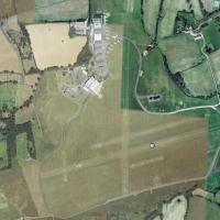
Situated south of London in Surrey, this grass airfield complex named EGKR Redhill features five runways and five or more helipads. Creator Dominique M. L. Donzelot notes it uses existing objects a…
United Kingdom
NZMK Motueka sits 1 nautical mile southwest of the town of Motueka, in the Tasman Bay area of the upper South Island. Credits go to Lawrie Roache for Afcad and object placement, Godfrey Tier for si…
New Zealand