Page 102
Searches the whole library — filter by sim & category on the results page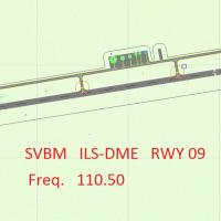
The setup centers on Jacinto Lara International in Barquisimeto (ICAO SVBM), detailing an ILS beacon object library positioned to the right of runway 09. It remains compatible with any mesh and car…
 Venezuela (Bolivarian Republic of)
Clearwater Airpark, adjacent to KCLW, receives a refined ground layout with updated taxiways, refined aprons, and newly placed hangars. The package includes Airport_Buildings_AP.bgl and integrates …
 United States of America
An add-on for Jefferson County International Airport (0S9) comprises three .bgl files depicting Port Townsend downtown, ferry docks with cars, PT Paper Mill, two marinas, a US Coast Guard station, …
United States of America
An add-on for flight simulation locates Harrowbeer in Buckland Monachorum, Devon, inside Dartmoor National Park, about nine miles NNE of Plymouth and six miles south of Tavistock, under 10 Group. S…
 United Kingdom
A BGL file places a completely fictional aircraft carrier west of Los Angeles near KLAX, and Derek Souza credits it, with Blue Angels numbers 1 through 3 parked on the deck as a surprise for enthus…
United States of AmericaKarl Meindl authors the CV69 fix, which replaces the older CV-71 setup and includes only an updated install text for CV69.ZIP. It instructs deleting three bgl files—CarrierCV.bgl, ADE_CV71.bgl, KNP…
United States of America
Smith Graphics introduces the KLBB project for Lubbock Preston Smith International Airport in Texas, dating to 2008, with an auto-install program named Project_KLBB. By Smith Graphics, the KLBB lis…
United States of America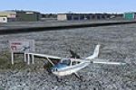
Mascouche airport, identified as CSK3, sits in Quebec, Canada, and has all real buildings plus a runway oriented to a new configuration; Sylvain Tremblay is credited. A Cessna is parked nearby on t…
 Canada
Chateau Airfield (NZ22) sits on the lower slopes of Mount Ruapehu in central North Island, where Mountain Air operates flights around Tongariro National Park. Refined elevation data and terrain ali…
 New Zealand
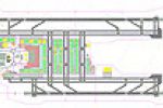
By design, the field presents two parallel runways, RWY 06L/24R at 3200 by 50 meters and RWY 06R/24L at 2440 by 50 meters, each with displaced thresholds and respective landing distances of 2895 an…
United Kingdom
Grzeslaw Bator authors the Polish airfield with code EPWK in Poland today officially. A variant folder named 1_EPWK_X supports the EPWK listing for the location, providing a dedicated reference for…
 Poland
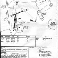
Eshott Airfield, identified as X5ES, features two new tarmac runways and can host up to 70 light GA and micro-light aircraft in its hangars; it includes animated objects, AI traffic, and auto-gen t…
United Kingdom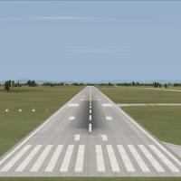
An ILS 11 approach for runway 11 at LRTR Traian Vuia International Airport in Timisoara, Romania adds frequency 110.900, identifier ITS, OBS 107, and a locator beacon at 378.00, linked to the ILS11…
 Romania
Westover ARB at KCEF in Springfield, Massachusetts gains military cargo and GA parking, relocates the control tower, adds a fire station with trucks, static fuel trucks, and new parking areas and b…
United States of America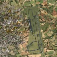
Paul Ting presents a version focused on Chiayi AFB in Taiwan, tied to registration RCKU, with a named variant called RCKU Enhanced and a file labeled RCKU.BGL. The entry relies on a single file in …
 Taiwan, Province of China
Jim Cook refines Otis ANGB (KFMH) near Cape Cod, Massachusetts, replacing structures and relocating the control tower, and adds parking for Military_Cargo and Military_Combat operations. AirNav and…
United States of America
In Washington, Tieton State (4S6) sits as a small airfield with added life, identified by the code 4S6 and credited to David Roch. Birds become visible only when advanced animations are enabled.
United States of America
Gates and a ramp with a FedEx cargo building appear at the KAVP site in Pennsylvania, and all jetways stay visible and operable, callable to the jet via CTRL-J. It removes the old closed runway and…
United States of AmericaBy Anwar Gonzalez, the public airport near Riohacha, Colombia, carries the designation SKRH with IATA RCH and ICAO SKRH, operated by Aerocivil. It sits at 13 m elevation (43 ft) and at coordinates …
 Colombia
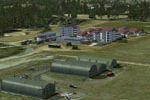
Near Neuchateau in France, the airfield presents hi-res photoreal ground with seasonal and night variants, an animated windsock, static planes, plus a police compound and a farm. It includes VAC_LF…
 France