Page 103
Searches the whole library — filter by sim & category on the results page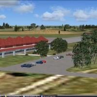
Mafikeng International Airport, identified by code FAMM, presents custom buildings and hangars in a South African setting. The arrangement, by Jacques Botha, includes a green hangar opened by nav2 …
 South Africa
CYHE, a British Columbia airfield in Hope, hosts the Vancouver Soaring Association. It operates seven school and recreational sailplanes and two Cessna L-19 Bird Dog tow planes, and a single .bgl f…
 Canada
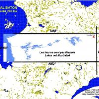
Gilles Gauthier maps lakes, shorelines, and rivers across the province of Quebec, including the Baie James hydroelectric territory. Two subfolders organize the data: Scenery contains BGL files labe…
Canada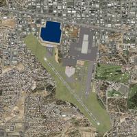
KMFE receives a v3.2 compatibility update featuring taxiway corrections based on satellite imagery for near-exact dimensions. Two BGL files KMFE_ADE_BCCRWe3_CVX and KMFE_ADE_BCCRWe3 appear, and the…
 United States of America
Located in Quebec, Canada, Battures de Beauport sits along a port segment where coal and ore are handled. By Pierre Baillargeon of Ailes Quebecoises, the project includes a ground imagery layer wit…
Canada
Airport Sembach (ETAS) near Ramstein, Germany, centers on a former airbase dating from 1951, which closed in 1995, built with standard objects and freeware. It is designed using Airport Design Edit…
 Germany
Scatsta airport in Scotland gains a minor expansion and remodelling, with the runway extended to 4800 feet and turning circles added at both ends. An ILS runway 24 approach uses frequency 108.10 an…
 United Kingdom
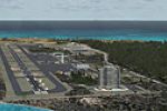
Eleutheria Island, Bahamas appears with the CJCRFX09 2009 CJCR SP2 designation, a CJCR-coded entry noted in the collection, tied to that code. All files except aircraft are included, and Jimmy R. M…
 Bahamas
Static aircraft and vehicles populate the terminal and general aviation areas at KSEA, Washington, in a project by Vince Marrone. Two items, a BGL named seatac and a seatac folder, accompany them, …
United States of America
An EGDC layout for Chivenor Airport in the UK is designed to blend with photo scenery and the included mesh, and includes four .bgl files: Chivenor EGDC.bgl, cvxEGDC.bgl, cvxEGDCflatten3.bgl, and E…
United Kingdom
By Jimmy R. Martin and Federico Malfu Sanchez, the correction addresses a floating runway on SA62 Ea Andalen and targets ARGENTINA_RANCHES_PACK_1.ZIP, noting that the related installation contains …
 Argentina
Within the NL2000 v4 framework, Gilze Rijen Air Base adds hand-crafted hangars and control towers, with photoreal imagery and accurate apron markings that mirror real layouts. The release relies on…
 Netherlands
The Lancaster Airport at KLNS in Pennsylvania gains a notably improved layout with adjusted aprons and a replaced terminal overall. Jim Cook provides two BGL files, KLNS_AFX_JC.bgl and KLNS_JC.bgl,…
United States of America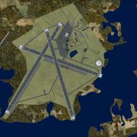
KALF in Rhode Island serves as a satellite to Quonset NAS and trains night fighter squadrons on F6F Hellcat and TBM Avenger. The model, by Fred Highland, reproduces the site circa 1945 from aerial …
United States of America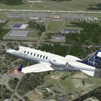
Local airport at Kinston, code KISO, in North Carolina lies near the town’s northeast edge and boasts one of the region’s longest runways. The project overlays a map to correct taxiways and roadway…
United States of America
An early version (version 1) by Roger Leupold presents an airport rendition featuring custom objects arranged to mirror taxiways, ramps, and lighting, with runways aligned using Google Earth imager…
 Australia
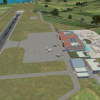
RCFG Nangan Airport on Matzu is one of the two airfields serving the Matzu Islands. Custom buildings derived from the El Formosa Project join newly built structures, while satellite imagery guides …
 Taiwan, Province of China
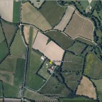
A private grass airfield in Vendée, west France, features a 550-meter strip suitable for GA aircraft. It sits about 15 nautical miles north of Les Sables d'Olonne, near Saint Gilles Croix de Vie, a…
 France
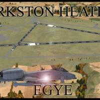
Defence Elementary Flying Training School operates the Slingsby T67M260 Firefly two-seat trainer at the airfield. Two files, EGYE_ADEX_GB.BGL and EGYE_ADEX_GB_CVX.bgl, accompany it and support its …
United Kingdom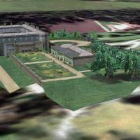
Lyme Park in Cheshire, UK appears in the Castles and Halls series, optimised with Horizon VFR Photographic, Generation X, volume 3, using a 2.4-meter-per-pixel terrain mesh and a 5-meter-per-pixel …
United Kingdom