Page 113
Searches the whole library — filter by sim & category on the results page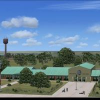
This fix corrects two missing files on the green hangar at Livingstone airport in Zambia, created by Frits Beyer and Jacques Botha. It links the two files to LIVINGSTONE.ZIP and places them in the …
 Zambia
The Rafael Nunez SKCG.bgl modification adds more realistic runway markings at Rafael Nunez Airport in Cartagena, Colombia, and repositions two PAPI rows. The change centers on Rafael Nunez Airport'…
 Colombia
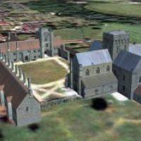
The hospital sits about a mile from Winchester, Hampshire, between the River Itchen and the Southampton road, dating to 1136. By Simon Swallow, all models use GMAX and align with Generation X VFR P…
 United Kingdom
Phoenix Sky Harbor International Airport (KPHX) receives authentic gate allocations, cargo ramps, and fully functional jetways, with jetways responding to CTRL+J for authentic boarding sequences. C…
 United States of America
Two main zones anchor this WWII Pacific project, including XBEL Bellows Air Force Base and MMS2, an island airfield with dirt runways and beaches for amphibious launches. Requires MMS1.ZIP and incl…
United States of America
Located at 21W in Washington, this modification fixes invisible trees at the end of runway 15 and heightens ground cues on approach. It relies on stock visuals and uses objects from a free library …
United States of America
Uwe Steenweg provides a fix for grass growth on the runway at Lahr, Germany. It supplies two BGL files, EDTL_ADEX_US_V-1.BGL and EDTL_ADEX_US_V-1_CVX.bgl, intended to replace the existing EDTL_ADEX…
 Germany
The NL2000 v4 environment depicts Enschede Airport Twente, featuring dual-purpose air base elements and static and dynamic facilities placed in their geographic positions. Version 4.02 aligns with …
 Netherlands
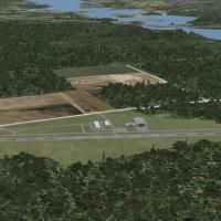
Youngstown Executive Airport opens in the early 1960s and closes in the late 1990s, serving the area southwest of Youngstown, Ohio and freight operators hauling car parts for Packard Electric. For …
United States of America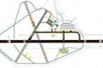
Carlisle, UK, gains an expanded layout with a jet apron housing six stands and several new buildings. Runway 07/25 extends to 7500 feet with ILS on both ends (108.30 MHz) and 250-foot stopways; Run…
United Kingdom
Located in New Brunswick, Bathurst Airport CZBF sits in Canada and includes an apron and parking for three aircraft at a time. The entry by Daniel Louvet adds airport information and charts, and no…
 Canada
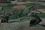
Near Canterbury in Essex, Clipgate Farm lies, and Pent Farm sits a few miles away on a downhill north–south strip with a steep approach to 24 and an unforgiving end ditch. Two new sounds accompany …
United Kingdom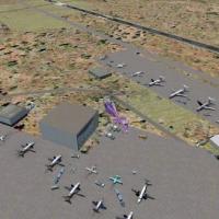
KSOW, in Arizona’s Show Low area, receives a simple add-on by Jimmy R. Martin that places cars, people, and aircraft around the field. It features improved runway lights with strobes and includes d…
United States of America
At KGKY in Texas, the edition adds and repositions GA parking, introduces new roads with Fire Station #12 and a fire truck, and replaces the terminal while expanding structures with additional FBOs…
United States of America
At PACV in Alaska, Jimmy R. Martin presents an add-on that uses FS Genesis terrain mesh to shape the surrounding landscape. The arrangement highlights PACV's Alaska location and the integration of …
United States of America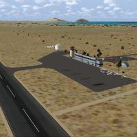
San Felipe Airport (MMSF) in Baja California, Mexico gains an improvement by Carlos Lopez, crafted with Airport Design Editor Program and using default buildings and objects. It is supplied as MMSF…
 Mexico
By Gera Godoy Canova, the Amazonas project of 1937 centers on the Amazon region with a Macchi 64 twin-engine amphibian, a Curtiss amphibian, and a Curtiss passenger aircraft. It supplies .BGL and .…
 Global (World)
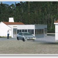
José Maia presents a freeware modification that overhauls a 20 by 20 kilometer area around Cerval Airfield near Valença do Minho, delivering newly built terrain and vegetation with custom autogen t…
 Portugal
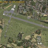
The modification relocates the runway and adjusts its length, and eliminates the closed runway 10/19. The changes add ATIS 127.05, implement ILS for runway 28 at 109.30, and introduce a new termina…
 India
India
Oxnard Airport KOXR, located in Oxnard, California, USA, appears as an add-on with moving airport vehicles, ramp lighting, and people. Jimmy R. Martin designed it, and a few static aircraft populat…
United States of America