
From Pucalpa to Iquitos up the river, Amazonia Air operates with stops at Contamana, Aguantan, Selvas and Nauta, flying twin Senecas, 206s, 208s, and a DC-3. By Gera Godoy Canova, it remains freewa…
 Peru
Peru
Aimed at Kuala Lumpur International WMKK, this upgrade adds gate assignments, cargo parking, and a redesigned road network with extra fuel trucks and enhanced apron lighting. It includes WMKK.bgl a…
 Malaysia
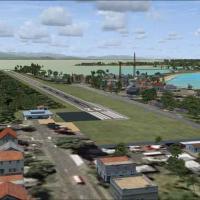
GMAX-modeled depiction of Bocas del Toro International Airport (MPBO) in Panama stands at v1.0, featuring a terminal, tower, and a radio antenna located at precise positions. It reworks surrounding…
 Panama
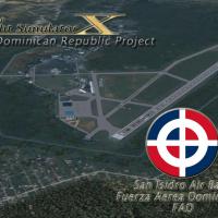
San Isidro base carries IATA ZXD and ICAO MDSI and appears as Vol. 1, locating about 25 miles east of Santo Domingo. Origin traces to 1953, when it operated under the name Trujillo until 1961, with…
 Dominican Republic
Jim Cook delivers a freeware improvement for Fairchild AFB at KSKA, refining taxiways, expanding aprons, and adding Military_Cargo parking positions to support wide transports. Two files, AFX_KSKA_…
 United States of America
In Maine, Bangor International Airport gains an improved layout with adjusted aprons, taxiways, and roads, plus GA parking and military cargo and combat parking at Air National Guard apron, moved b…
United States of America
Eric Cagan presents a KEKO_Elko_FSX upgrade for the sim, including updated libraries library_parking_lots_large_ss_FSX and parking_ss_FSX, plus RampLightLibrary and lightobj, with an ADE file inclu…
United States of America
By Alf Denham, three UK aerodromes receive placement refinements including Maypole (EGHB) near Kent, a grass-strip with improved hangar layout, Seething (EGSJ) in Norfolk with more precise markings…
 United Kingdom
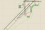
An enhanced version adds Military_Cargo and Military_Combat parking spaces, alongside commercial and GA areas, and tightens taxiways and aprons. Two BGL files, AFX_KYUM_JC.bgl and KYUM_JC.bgl, acco…
United States of AmericaRonan Kyne compiles version 1.00, covering eight Irish airfields such as Weston EIWT and Sligo EISG. Birr EIBR, Galway EICM, Connamarra EICA, Inis Mean EIMN, Iniseer EIIR, and Waterford EIWF appear…
 Ireland
The Pontarlier airfield sits in Franche-Comté, near the Swiss border, and serves general aviation with ULM activity. Not compatible with earlier versions, it shows a single runway instead of the tw…
 France
Ciudad Bolivar City in southern Venezuela serves as the geographic focus of this add-on, which features a terminal building, control tower, fire station, and heliports with detailed visuals. It is …
 Venezuela (Bolivarian Republic of)
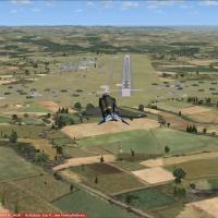
Buchel air base sits near the Mosel in Rhineland-Palatinate, hosts Jagdbombergeschwader 33 and Tornado operations, and remains active. A lite variant omits trees and other frame-reducing elements, …
 Germany
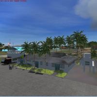
Five Caribbean islands—Canouan (TVSC), E. T. Josua (TVSV), J. F. Mitchell (TVSB), Mustique (TVSM), and Union I. Int (TVSU)—receive redesigned roads, coastlines, and landclass across principal islan…
 Saint Vincent and the Grenadines
Tokushima’s RJOS airfield receives Ian W’s layout update, updating hangars, towers, and terminals to reflect real-world layouts while showing runway extensions under construction. Ground vehicles a…
 Japan
Japan
An airport add-on for the Bella Coola area, CYBD in British Columbia, presents a loose rendition by Bob Caparoula based on a digital image. It includes two .bgl files, stays freeware, and utilizes …
 Canada
Love Field in Dallas receives ADE v1.47 support, designed for default airport and delivered as three BGL files: KDAL_ADE_RS.BGL, KDAL_ADE_CW_RS.BGL, and KDAL_ADE_OBJ.BGL. The CW_RS variant activate…
United States of America
At Livingstone International Airport in Zambia, creators Frits Beyer and Jacques Botha present a layout featuring custom-designed buildings and hangars, plus radars and lights with custom effects. …
 Zambia
Ian Thatcher provides a revised landclass for New Zealand, based on his earlier work, and ships a single BGL file. Spring through fall guide the results, while winter appearances remain mismatched …
 New Zealand
ETHF Fritzlar operates as a military airfield and serves as the base for Heeresfligerregiment 36, aligning the installation with German forces in the Fritzlar area. It optimises use with VFR German…
Germany