Page 40
Searches the whole library — filter by sim & category on the results page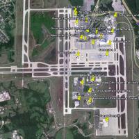
KCVG presents Terminals 1–3 with parking structures, skywalks, and annexes, along with the Delta hangar, DHL cargo facility, Comair headquarters, and a Doubletree hotel. It relies on ez_1.zip, rw12…
 United States of America
Neil Birch presents a UK VFR Library, with permission from Alan Fidler. Unzipping yields three folders, including the UKVFR LIBRARY, with two others whose names are not specified, and the arrangeme…
 United Kingdom
Ian Thatcher resizes and rewords all files to enable Autogen, now at 60% with a 6fps gain on the test computer. The changes apply to all included elements and improve its compatibility across confi…
 Global (World)
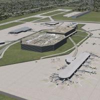
A Florida airport enhancement at KTPA adds a terminal replacement, parking areas, vehicles, and GA hangars, designed for a flight-simulation platform. It requires RWY12 Libraries, and distributes B…
United States of America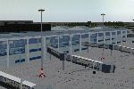
The EGBB enhancement replaces Runway 06-24 with taxiways L and T, updates markings and signs, moves E7, C1, and C2 for real-world alignment, and adds accurate terminal-area buildings behind the mai…
United Kingdom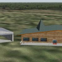
This version 2 release by Mahmoud Fadli and the VATSIM Jordanian FIR covers OJAI, OJAM, OJAQ, and OJMF with updated taxiway configurations and Amman, Aqaba, Mafraq landclasses, drawn from real-worl…
 Jordan
On a reclaimed island off Osaka Bay, the addition aligns terminals, aprons, and gates with real coordinates using satellite references. The RJBB_IanW folder anchors the project; the second runway a…
 Japan
JapanKEDW folder on Edwards AFB in California expands on-base capabilities with two refuel stations and static aircraft including KC-135, F-15C, A-10, Predator, and C-130 Hercules. Credits go to Guy Dio…
United States of America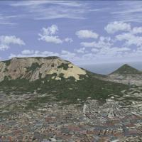
Created by Domonique Dantu, this mesh refinement sharpens Table Mountain’s silhouette and elevates terrain fidelity over the Cape Town area, offering a clearer sightline on low-altitude approaches.…
 South Africa
A stock aircraft carrier sits offshore near Honolulu, identical to the San Diego variant, while a landable Battlestar Galactica sits above the carrier at 27,500 feet, offering a clear reference poi…
United States of America
An aircraft environment add-on covers a network of Florida and Caribbean aviation sites, spanning Key West, Miami, Havana, Marathon and beyond. By Chris Carel, it lists 19 navigation locations with…
Global (World)A Melbourne International layout by Ray Smith presents two BGL configurations, YMML_ADE_RS.BGL and YMML_ADE_CW_RS.BGL, plus YMML_ADE_OBJ.BGL that must accompany either option. The crosswind edition…
 Australia
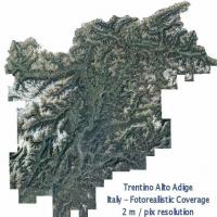
By Raimondo Taburet, ItalVFR depicts a 2 m resolution photorealistic depiction of the Trentino and South Tyrol region during the summer. It covers the whole area and relies on a bgl file to convey …
 Italy
ItalyRay Smith develops a KMEM modification using ADE (v1.46) that refines layout with two runway configurations and a crosswind setup, letting all four runways handle departures and arrivals. File KMEM…
United States of America
A Swiss landclass project by Michel Grandjean updates city layouts by correcting and positioning settlements with more than 5,000 inhabitants. The work focuses on accurate geographic coverage acros…
 Switzerland
By Victor Stephanovici, version 2.0 depicts Bucharest with all-season imagery, night lighting, and water visuals for the Bucharest area. No autogen files exist to accompany the work, and the file b…
 Romania
By Sylvain Parouty, this v2 model recreates a 1990s Clemenceau carrier with dual catapults, jet blast deflectors, and arrestor wires, designed for FSX Acceleration. Install uses VEH_Clemenceau V2.0…
 France
KSTL in Missouri receives a v1.5 update that aligns nav aids and the Runway 11/29 to 2008 configurations. It also fixes the 30L approach frequency and corrects the ILS display, with taxiway A6 desi…
United States of America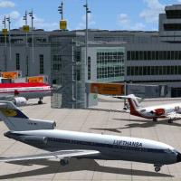
Thomas Ruth delivers a refined interpretation of Duesseldorf Airport (EDDL), unifying two revisions into a single, more authentic layout with elevated walkways and animated jetways. The effort adds…
 Germany
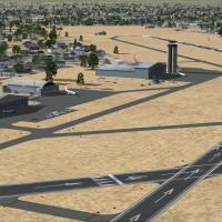
By Steve Ziegler, this set encompasses over 133 Kansas airfields built with native objects, requiring no additional libraries or textures and delivering frame-rate friendly performance, with some f…
United States of America