Page 2
Searches the whole library — filter by sim & category on the results page
Designed for the Carenado 208 and compatible with the default variant, this setup delivers a Lama Chanting Band to Buthan’s mountain airfields. A BHUTAN FLIGHT ONE directory includes a terrain pair…

A high-altitude alpine challenge by Robbie Albers centers on the Megeve altiport in the French Alps, where limited runway length and surrounding peaks demand precise descent rates and strict approa…
A De Havilland Twin Otter taxis from Chefornak at 10 a.m., using RW16/34 with 40 ft elevation and radio 122.7. It climbs to 4,700 ft toward Nunapichuk RW36/18 at 12 ft, with 122.9 and a cruise prof…
 Base Model
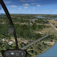
An operations scenario places a forward command post on the north shore of the Agate reservoir to coordinate firefighting resources as fires burn to the east. Today you fly the Air Boss up to the p…
 Base Model
Inside The Good Life folder, the setup depicts the Grumman Goose G21A Fish variant en route to Glacier Park International (KFCA) and back, while a glacier_park.RWD file anchors the rewards data for…
An F/A-18 Hornet engages in escort duties beside a high definition landable carrier to shepherd SP677, an unmarked 737, to an undisclosed airport in Iraq off the Kuwaiti coast. The setup lives in C…
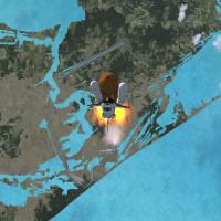
Erwin Welker models a freeware shuttle sequence featuring a Cape Canaveral, Florida launch and a second orbital pass, with the required ATLANTIS-1.ZIP from Bruce Fitzgerald. A second orbital phase …
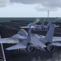
Five F-14 Tomcats operate from carrier CV69-12, flying patterns and landing three times. The scenario supports Free Flight or Quick Task modes, with rewards such as Buzz the Tower and Cable 3 tied …
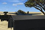
A heavy DC-3, described as old, flies a transport flight for the Madagascarian military. Credit goes to Thorsten Reichert, and the associated image carries the file name madascrg.gif, offering a vi…
Off Sharm El Sheikh, the AugustaWestland EH101 helicopter teams with F18 fighters to cover BigBird2 as BigBird1 departs for a separate pickup, offering three rewards for outcomes such as landing th…

An historical flight scenario places a Concorde in Air France colors on a Charles de Gaulle to John F. Kennedy route, with Robbie Albers credited as creator. The setup relies on two external zip fi…

An F/A-18 Hornet conducts a carrier reconnaissance sortie with you as the wingman to Viper-1 off the coast of Iraq, focusing on Basrha Int'l and Shaibah Airports at dusk. You maintain within 0.7 na…
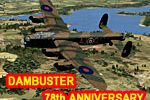
Two Lancasters, coded as 101 Lancaster DB-101 in the air traffic list, launch simultaneously from Menden EDLA and Fritzlar ETHF to cross along the Moehne–Eder route before returning to base. The AJ…

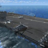
Two components anchor this scenario: T-45C Goshawk by Dino Cattaneo and a non-moving Nimitz carrier updated by Javier Fernandez, tied to T45CV185.ZIP and USS_NIMITZ_IKE_VERSION2.ZIP. Takeoff and la…
A 737-800 variant focuses on an ILS approach drill, using a supplied skin by Jon Murchison for the default airframe. It includes three RWD files named ILS_Reward.RWD, NZDN2.RWD, and NZDN3.RWD place…

An A320 variant navigates a routing from LFLC Clermont-Ferrand to LFPO Paris Orly, set against a windy Auvergne evening. French dialogue and text accompany the scenario, including the aircraft brie…
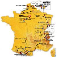
Twenty-one flight plans span the stages starting in Liege, Belgium on 30 June 2012, with routes largely built around the default Cessna 172. Stage 14 appears at 8,500 ft while stage 17 passes the A…

The Oregon Ablaze scenario receives a correction addressing an immediate crash on startup, linked to the helicopter tailboom potentially contacting the hangar, by William D. Smith. PHMISX_1.ZIP fix…
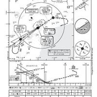
Ronald Reagan approach, described as dangerous, features a visual runway 19 approach that parallels the White House grounds and restricts overflight. The scenario uses a real schedule from Airtran …
Credit goes to David J. Crandall for a remake derived from the classic emergency flight sim SimCopter by Maxis, offering increasing city challenges across levels. A library list catalogs all object…