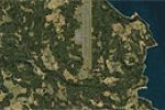
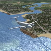
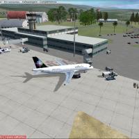
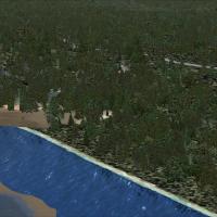
FSX Scenery

Page 89

Sort
Reset
Preview screenshot

Worcester Regional Airport

By Jim Cook, the revision adjusts aprons, taxiways, and roads while replacing most default buildings and adding a fire station, parking lots, static vehicles, aircraft, and lighting poles. Two BGL files named KORH_AFX_JC.bgl and KORH_JC.bgl accompany the work, with Direct Air assigned gates.

Country
United States of America
File Size
10.68 KB
Total Downloads
392
Star Rating
3/5
No image available.

Biak City

Biak City, designated by WABB, centers on the urban area of Biak in Indonesia, and this framing keeps the focus squarely on Biak's urban core. The note confirms Biak’s urban focus and implies no broader regional extension.

Country
Indonesia
File Size
4.99 KB
Total Downloads
391
Preview screenshot

Benbecula Airport

Benbecula Airport (IATA BEB, ICAO EGPL) sits on Benbecula in the Outer Hebrides and is owned and maintained by Highlands and Islands Airports Limited. By Gordon Barnes, the BGL file EGPL_ADEX_GB.BGL is provided for use with regional operations, supporting connections to the Scottish mainland and other Hebrides, including emergency air ambulance flights and missile-range support.

Country
United Kingdom
File Size
588.45 KB
Total Downloads
390
Star Rating
2/5
Screenshots
1
Preview screenshot

Mountain Top

On the Alaska–British Columbia border, Mountain Top (CYMN) sits as a fictional high-altitude airfield a few dozen miles from Juneau at 6800 feet. The locale includes a detailed city, with credit attributed to Andy Johnston.

Country
Canada
File Size
4.13 MB
Total Downloads
390
Screenshots
1
Preview screenshot

Canakkale Airfield

Located at LTBH in Turkey, the airfield and surroundings deliver VFR coverage with realistic autogen, landclass improvements, and photoreal components. By Sunay Kilic, it relies on grcoastlines.zip from Yiannis Dermitzakis and notes LTBH09X1.ZIP for compatibility with related content.

Country
Turkey
File Size
33.68 MB
Total Downloads
390
Star Rating
1/5
Screenshots
3
Preview screenshot

Canada Day Fireworks Project

An active BGL-based setup activates fireworks displays for Canada Day with an XML source providing GPS coordinates for each site and timing marks such as HOD=22,22 and MOH=15,55. The coverage spans major centers from Victoria and Vancouver in British Columbia to Ottawa and Toronto in Ontario.

Country
Canada
File Size
1.97 MB
Total Downloads
389
Screenshots
14
Preview screenshot

Tri-Cities Regional Airport

KTRI in Kingsport/Bristol, Tennessee receives a dedicated enhancement by Rob Touchtone, aligning gates and parking for Delta, US Airways, American and Allegiant, and adding a cargo ramp for civilian and military use; a command via CNTRL-J summons the jet.

Country
United States of America
File Size
146.06 KB
Total Downloads
389
Preview screenshot

Winter Hill TV Transmitter

Stewart Haworth documents the Winter Hill transmitter site near Manchester, United Kingdom, detailing its geographic setting and the author credit. The accompanying image shows a visual reference of the facility, linking the record to a single illustrated view and confirming the subject.

Country
United Kingdom
File Size
5.56 MB
Total Downloads
389
Screenshots
1
Preview screenshot

Hanan International Airport

On Niue Island, this add-on for the Hanan air facility uses VECTOR LANDCLASS (VLC) and remains freeware for personal, non-commercial use. Credits go to Lawrie Roache for object placement and to Robin Corn for VLC libraries.

Country
Niue
File Size
3.26 MB
Total Downloads
388
Star Rating
1/5
Screenshots
9
Preview screenshot

USS Patoka AV-6

A model of Patoka AO-9 sits at anchor as a mooring mast docking platform across five geographic locations, with airports MPAO Panama Roads, KNAO Pensacola Bay, KAPO Narragansett Bay, VGAO Old Plantation Flats, and KSAO San Francisco Bay, and five saved flights plus displacement 16,800 tons and length 417 ft 10 in.

Country
Global (World)
File Size
3.93 MB
Total Downloads
388
Star Rating
3/5
Screenshots
2
Preview screenshot

Fulton Seaplane Base 0FD6

By Bruce Bouley, the 0FD6 designation near Ballard Cove adds a seaplane dock, static seaplane, a medium marina, resort hotel, and estates close to Sebastian, Florida. Coordinates are N27°54.45', W80°29.19', activation date November 1986, and the base is Private Use with an ADF/NDB on 508.0.

Country
United States of America
File Size
12.63 MB
Total Downloads
387
Star Rating
5/5
Screenshots
2
Preview screenshot

Eyguieres/Salon Airport

Eyguieres/Salon Airport (LFNE) has two grass runways and a short landing strip that suits gliders, with tower control; Daniel Louvet gives visual references because radio navigation equipment is absent. Airport and chart information accompany this project.

Country
France
File Size
787.74 KB
Total Downloads
387
Screenshots
3
Preview screenshot

Westchester County Airport

An improved regional airport revision at White Plains, New York, adjusts aprons and relocates the terminal to avoid highways, and adds two moving jetways. Replaces most default buildings and adds parking lots, static vehicles, aircraft, and light poles; two BGL files KHPN_AFX_JC.bgl and KHPN_JC.bgl accompany the work by Jim Cook.

Country
United States of America
File Size
27.69 KB
Total Downloads
386
Star Rating
1/5
Preview screenshot

Flugplatz Sankt Stephan

Bern, Switzerland, in the Obersimmental region of the Bernese Alps, hosts a single runway that opens annually for hunters and old timers. A main hangar is added, and the layout relies on RARON.ZIP for surface imagery, with ADE by Jon Masterson listed and hangar details by Dennis Waggoner and Jim Dhaenens.

Country
Switzerland
File Size
502.66 KB
Total Downloads
385
Screenshots
1
Preview screenshot

Koeberg Power Station

Frits Beyer documents a custom model of Koeberg facility near Cape Town, South Africa, built from photographs found online. The project references the surrounding harbor areas, requiring Cape Town Harbor, Simons Town harbor, and Robbin Island in its layout, with the main building as a hand-crafted addition.

Country
South Africa
File Size
245.96 KB
Total Downloads
385
Star Rating
1/5
Screenshots
1
Preview screenshot

RJOY Yao Real

Kenichi Ochiai creates version 2.0 of the work bearing the RJOY Yao prefix, a two-part identifier that appears in the original designation. This second iteration strengthens the link between the listed creator and the named project while preserving the initial naming structure.

Country
Japan
File Size
122.82 MB
Total Downloads
385
No image available.

Emma Field Placeholder

This is the second Emma Field rendition, a simplified stand-in compared with the original payware. It relies on freeware or default objects rather than original payware, and a separate Airport_Buildings_AP.bgl file is placed in the global directory.

Country
United States of America
File Size
15.49 MB
Total Downloads
384
Preview screenshot

Swiss Highway Tunnels

A file named CVX_SwissTunnels.BGL hides highways by placing them in tunnels, preventing streets from crossing mountains and altering how the terrain is perceived. Martin Rothenmund authors the work, the scope covers the entire Switzerland area and hides highways within underground passages.

Country
Switzerland
File Size
83.11 KB
Total Downloads
384
Screenshots
2
Preview screenshot

Allentown/Bethlehem Airport

In the Lehigh Valley, Allentown/Bethlehem Airport, code KABE, receives an ADE-based layout with accurate parking for carriers and cargo operators. Jetways remain fully functional and respond to CTRL+J, with no separate library or extra files required for operation.

Country
United States of America
File Size
70.73 KB
Total Downloads
384
Preview screenshot

Elbtunnel

Elbtunnel in Hamburg, northern Germany, corrects the default layout by removing an erroneous bridge across the Elbe River where the tunnel sits. It measures 8 lanes and 426.5 meters in length, dating to 1975 as part of Autobahn A7 from the Danish border to Fuessen/S-Germany, by Uwe Schweitzer.

Country
Germany
File Size
134.35 KB
Total Downloads
384
Screenshots
1